
Belton is a village in the civil parish of Belton and Manthorpe, in the South Kesteven district of Lincolnshire, England. It is situated on the A607 road, and 3 miles (5 km) north from the market town of Grantham. In 1921 the parish had a population of 145.

Asgarby is a village in the civil parish of Asgarby and Howell, in the North Kesteven district of Lincolnshire, England. It is situated on the A17 Boston to Newark road, 3 miles (5 km) east from Sleaford and 2 miles (3 km) north-west from Heckington. In 1921 the parish had a population of 63. On 1 April 1931 the parish was abolished to form "Asgarby and Howell".
Aubourn is a small village in the civil parish of Aubourn with Haddington, in the North Kesteven district, in the county of Lincolnshire, England. It is just east of the A46, in between Lincoln and Newark-on-Trent. It has a one-way system that is unusual for a small countryside village, and a public house called 'The Royal Oak'. In 1921 the parish had a population of 212. On 1 April 1931 the parish was abolished to form "Aubourn, Haddington and South Hykeham".
Bassingthorpe is a small village in the civil parish of Bitchfield and Bassingthorpe, in the South Kesteven district of Lincolnshire, England. It is 5 miles (8 km) south from Grantham, and on a C class road between the B6403 to the west and the B1176 to the east. In 1921 the parish had a population of 78. On 1 April 1931 the parish was abolished and merged with Bitchfield to form "Bitchfield and Bassingthorpe".

Birthorpe is a hamlet in the civil parish of Billingborough, in the South Kesteven district of Lincolnshire, England. It is situated less than 1 mile (2 km) west from Billingborough and the B1177 Pointon Road, and 2 miles (3 km) east from Folkingham. Birthorpe was formerly in the parish of Semperingham, in 1866 Birthorpe became a separate civil parish, on 1 April 1931 the parish was abolished and merged with Billingborough. In 1921 the parish had a population of 46.

Bitchfield is a village in the civil parish of Bitchfield and Bassingthorpe, in the South Kesteven district of Lincolnshire, England. It consists of two groups of buildings connected by Dark Lane, known as Bitchfield and Lower Bitchfield, collectively called Bitchfield. The village is situated approximately 6 miles (10 km) south-east from Grantham, and on the B1176 road, running east and parallel to the A1. In 1921 the parish had a population of 95. On 1 April 1931 the parish was abolished and merged with Bassingthorpe to form "Bitchfield and Bassingthorpe".

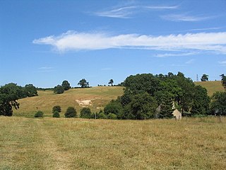
Braceby is a village in the civil parish of Braceby and Sapperton, in the South Kesteven district of Lincolnshire, England. The village includes a roadside nature reserve sheltering 250 species of plant life.
Gunby is a village and former civil parish, now in the parish of Gunby and Stainby, in the South Kesteven district of Lincolnshire, England. It is situated close to the borders with Leicestershire and Rutland, and 9 miles (14 km) south from Grantham, and 2 miles (3 km) west from the A1 road. In 1921 the parish had a population of 119. On 1 April 1931 the parish was abolished and merged with Stainby to form "Gunby and Stainby".
Stainby is a village and former civil parish, now in the parish of Gunby and Stainby, in the South Kesteven district of Lincolnshire, England. It is situated 2 miles (3.2 km) west from the A1 road, 1.5 miles (2.4 km) east from the Viking Way and the Leicestershire border, and 8 miles (13 km) south from Grantham. In 1921 the parish had a population of 117.
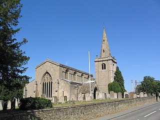
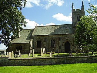
Witham on the Hill is a village and civil parish in the South Kesteven district of Lincolnshire, England. The population of the civil parish was 260 at the 2011 census.
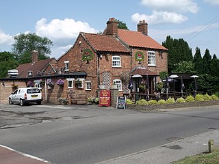
Old Somerby is a village and civil parish in the South Kesteven district of Lincolnshire, England, 3 miles (5 km) south-east of Grantham. It lies on the B1176 road, with the village centre about 1 mile (1.6 km) east of its junction with the A52 and B6403, and adjacent to the East Coast Main Line.

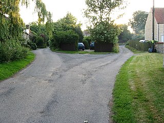
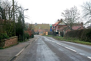
Kirkby Green is a small village in the North Kesteven district of Lincolnshire, England. The village lies east from Scopwick on the B1191 road to Timberland, 10 miles (16 km) south-east from the county town of Lincoln, 6.5 miles (10.5 km) south-west from Woodhall Spa, and 8 miles (13 km) north from Sleaford.
Careby Aunby and Holywell is a civil parish in the district of South Kesteven, south-west Lincolnshire, in England. It stretches from the county border with Rutland in the west to the River West Glen in the east. The B1176 road from Corby Glen passes through Careby and on past Aunby toward Stamford. The main London to Scotland railway line passes through the parish, the line upon which Mallard took the speed record for the LNER.

Denton is a hamlet and former civil parish, now in the parish of Cuddesdon and Denton, in the South Oxfordshire district, in Oxfordshire, England. Denton's toponym is derived from the Old English den-tun meaning "valley farmstead". Denton is in a fold of the landscape, between the two hills on which Cuddesdon and Garsington stand. Denton is an ancient manor and had its own civil parish, but it was merged with neighbouring Cuddesdon in the 20th century.

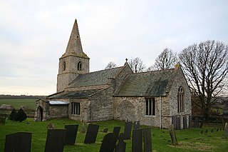
Careby is the principal village in the civil parish of Careby Aunby and Holywell, in the South Kesteven district of South Kesteven, Lincolnshire, England. The River West Glen flows through the parish, near Careby, forming part of the parish boundary. In 1921 the parish had a population of 116. On 1 April 1931 the parish was abolished to form "Careby, Aunby and Holywell".
Pilsgate is a hamlet and former civil parish, now in the parish of Barnack, in the Peterborough district, in the ceremonial county of Cambridgeshire, England. Pilsgate is close to the county boundary and 3 miles (5 km) south-east of Stamford, Lincolnshire. In 1881 the parish had a population of 125.
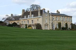
Holywell is a tiny settlement in the civil parish of Careby Aunby and Holywell, in the South Kesteven district of Lincolnshire, England. It lies 5.5 miles (9 km) north from Stamford and 6 miles (10 km) south-west from Bourne. It is a collection of houses around a country house and park. The park includes a small private church dedicated to St Wilfrid. Ornamental lakes have been restored over the last 20 years, and new gardens laid out. In 2009 the gardens were open to the public through the National Garden Scheme.

Aubourn with Haddington or Aubourn and Haddington is a civil parish in the North Kesteven district of Lincolnshire, England. The population of the civil parish at the 2011 census was 460.

Gunby and Stainby is a civil parish in the South Kesteven district of Lincolnshire, England. According to the 2001 Census it had a population of 141, falling to 136 at the 2011 census. It includes the hamlets of Gunby and Stainby.

Londonthorpe and Harrowby Without is a civil parish in the South Kesteven district of Lincolnshire, England. According to the 2001 Census it had a population of 4,344, in 1743 households, increasing to a population of 5,133 at the 2011 census. It includes the village of Londonthorpe and the hamlet of Harrowby, Lincolnshire.

