Awutu Senya District | |
|---|---|
Former District | |
 Club Amsterdam in Awutu, Ghana | |
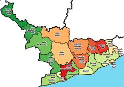
 Districts of Central Region | |
 Awutu Senya District Location of Awutu Senya District within Central | |
| Coordinates: 5°30′45.72″N0°30′49.68″W / 5.5127000°N 0.5138000°W | |
| Country | |
| Region | |
| Capital | Awutu Breku |
| Government | |
| • District Executive | Sampson Abbey Armah |
| • Presiding Member | William Danny Osardu |
| Area | |
• Total | 279.9 km2 (108.1 sq mi) |
| Population (2021) | |
• Total | 161,460 [1] |
| Time zone | UTC+0 (GMT) |
| ISO 3166 code | GH-CP-__ |
Awutu Senya District is a former district that was located in Central Region, Ghana. [2] [3] Originally it was part of the larger Awutu/Effutu/Senya District , which split in two on 29 February 2008. A few years later, on 28 June 2012, the Awutu Senya District itself split into two new districts: Awutu Senya West District (capital: Awutu Breku) and Awutu Senya East District (which was later elevated to municipal district assembly status on 15 March 2018; capital: Kasoa). The district assembly was located in the southeast part of Central Region and had Awutu Breku as its capital town.