Dharmapuri, is a city in the western part of Tamil Nadu, India. The town is located at 50 km from Krishnagiri, 69 km from Salem, 126 km from Bangalore, 200 km from Coimbatore, and 300 km from the state capital Chennai. It is located between latitudes N 11 47’ and 12 33’ and longitudes E 77 02’ and 78 40’. It is one of top leading mango cultivator and producer of state.

Hogenakkal Falls is a waterfall in South India on the Kaveri river on the border between Dharmapuri district of Tamil Nadu and Chamrajnagar district of Karnataka. It is located 127 km (79 mi) from Bangalore, 165 km (103 mi) from Kollegal, 147 km (91 mi) from Kolar, 152 km (94 mi) from Kolar Gold Fields, 46 km (29 mi), 181 km from Mysore, and 46 km from Dharmapuri. It is sometimes referred to as the "Niagara Falls of India," it is known for bathing areas and hired boat rides and as a major tourist attraction. Carbonatite rocks in this site are considered to be the oldest of its kind in South Asia and one of the oldest in the world. The Government of Tamil Nadu made a proposal to convert the falls into providing drinking water for the state.

Krishnagiri district is one of the 38 districts of the state of Tamil Nadu, in India. This district is carved out from Dharmapuri District by 2004. The municipal town of Krishnagiri is the district headquarters. In Tamil Nadu, e-Governance was first introduced at Krishnagiri district under the National e-Governance Project (NEGP) in revenue and social welfare departments on a pilot basis. The district is one of the largest producers of mangoes in India. As of 2011, the district had a population of 1,879,809 with a sex-ratio of 958 females for every 1,000 males.

Dharmapuri is one of the 38 districts in the state of Tamil Nadu in India. It is the first district created in Tamil Nadu after the independence of India by splitting it from then-Salem district on 2 October 1965. The other major towns in the district are Harur, Palacode, Karimangalam, Nallampalli, Pennagaram and Pappireddipatti. Dharmapuri District is one of the major producers of mango in the state, fine quality granite is found in the district. It is also one of the main sericulture belts in the state. Around 30 percent of the district's area is under forest cover. Kaveri enters Tamil Nadu through this district. Dharmapuri district had the lowest literacy rate of 74.23% in Tamilnadu during the 2011 census.

Kadathur is a panchayat town in Dharmapuri district in the Indian state of Tamil Nadu. Kadathur is situated 20 kilometres (12 mi) southeast of Dharmapuri. It is in the southern region of the district.
Papparapatti is a panchayat town in Dharmapuri district in the Indian state of Tamil Nadu. The original name of this town was Pallur Pettai, later it was officially renamed as Papparapatti by the local government. The name Papparapatti was derived from Parpanar petai, which means the place where Brahmin community people lives.
Pappireddipatti is a Town Panchayat of Dharmapuri district in the Indian state of Tamil Nadu and also a revenue Taluk of Dharmapuri district.

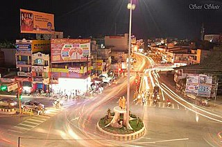
Krishnagiri is a municipality in the state of Tamil Nadu, India, and it serves as the administrative headquarters of Krishnagiri District formed in 2004. It is located at the bottom of syed basha Hills, and the town is fully surrounded by hill rocks. It is located 250 km from Chennai, 45 km from Dharmapuri, and 90 km from Bengaluru. Krishnagiri is known as "Mango Capital of India" as mangoes are cultivated as the main crop, and the land here is extremely fertile with rich access to fresh water making it amenable to growing crops. Krishnagiri is the site of significant business and residential development. The Krishnagiri Dam was built in 1967.

Periyar University is a university in Salem, Tamil Nadu, India. It was established by the Government of Tamil Nadu in 1997. It is named after social reformer Thanthai Periyar E. V. Ramasamy. The University Grants Commissions, New Delhi bestowed 2f status in 1998 and 12(B) status in 2005 to the university. It is accredited by NAAC with 'A++' grade. It has been awarded a cumulative grade point average (CGPA) of 3.61 out of 4 points. University ranked Second in India only after to Mumbai University and First in Tamil Nadu among State Universities. Periyar University is the first State University to rank "A++" grade.
Buddireddipatti is a village in Dharmapuri district, Tamil Nadu, India.
Bommidi is a panchayat town in Dharmapuri district, Tamil Nadu, India. Bommidi is also known as B. Mallapuram. Bommidi's name is used for the railway station, the police station situated at Nadur, the post office, and bus transportation, while the name "B. Mallapuram" is used for schools, hospitals, and government officials.
Palacode taluk is a taluk in the Dharmapuri district of the Indian state of Tamil Nadu. The headquarters of the taluk is the town of Palacode. Part of Cauvery North Wildlife Sanctuary is located in this taluk.
Pappireddipatti taluk is a taluk in the Dharmapuri district of the Indian state of Tamil Nadu. The headquarters of the taluk is the town of Pappireddipatti.

Pappireddippatti is a state assembly constituency in Tamil Nadu, India, that was formed after constituency delimitation in 2007. Located in Dharmapuri district, it comprises portions of the Dharmapuri and Pappireddipatti taluks. It is included in the Dharmapuri parliamentary constituency for elections to the Parliament of India.
Pappireddipatti block is a revenue block in the Dharmapuri district of Tamil Nadu, India. It has a total of 19 panchayat villages.

Gettupatti is a village in Dharmapuri District of Tamil Nadu State, India.
It comes under Dokkubothanahalli Panchayath and its south regions is covered by thoppur forest.
It is located 20 km towards South from Dharmapuri and 308 km from State capital Chennai.

Ammapalayam is a small village situated in Dharmapuri district, Tamil Nadu state in southern India. The village has one middle school.
Mallapuram and similar can mean these places in India:
Kovilur is a small Village in Nallampalli Block in Dharmapuri District of Tamil Nadu State, India. It comes under Nallampalli Panchayath. It is located 10 km towards South from District headquarters Dharmapuri. 4 km from Nallampalli.
Kadagathur is a village panchayath under Dharmapuri Block and in Dharmapuri district in the state of Tamil Nadu, India. This village is located 6 km away from District Capital Dharamapuri.


