
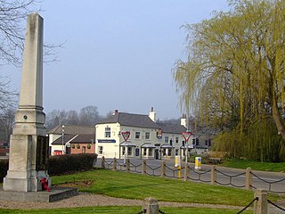
Blyth is a village and civil parish in the Bassetlaw district of the county of Nottinghamshire, in the East Midlands, north west of East Retford, on the River Ryton. The population of the civil parish as of the 2011 census was 1,233, and this increased to 1,265 in 2021. It sits at a junction with the A1, and the end of the motorway section from Doncaster.
Lowdham is a village and civil parish in the Newark and Sherwood district of Nottinghamshire between Nottingham and Southwell. At the 2001 census it had a population of 2,832, increasing to 3,334 at the 2011 Census. Two main roads slicing through the village are the A6097 south-east to north-west and the A612 between Nottingham and Southwell.

Collingham is a village and civil parish in Nottinghamshire, England. The population at the 2011 Census was 2,738.
Annesley is a village and civil parish in the Ashfield district of Nottinghamshire, England, between Hucknall and Kirkby-in-Ashfield. At the 2011 census, it had a population of 1,162, and this increased to 1,814 at the 2021 census.

Averham is a village and civil parish in the Newark and Sherwood district of Nottinghamshire, England. According to the 2001 census it had a population of 187, increasing to 294 at the 2011 census, however Averham alone reported 215 residents at the 2021 census. The village is just west of Newark-on-Trent. Staythorpe Power Station is south-west of the village.

Balderton is a village and civil parish in Nottinghamshire, England, which had a population of 9,757 at the 2011 census, increasing to 9,917 at the 2021 census.
Barnby Moor is a village and civil parish in the Bassetlaw district of Nottinghamshire, England, with a population of 257, increasing to the 2011 Census to 278, and dropping marginally to 274 in 2021. The village is about three miles north of Retford.
Egmanton is a small village and civil parish in Nottinghamshire, England, and is located one mile south of Tuxford and one mile north of Laxton. The population of the civil parish taken at the 2011 Census was 286. The name derives from the Old English words for Ecgmund's farm/settlement.

Farndon is a small village and civil parish in Newark and Sherwood district of Nottinghamshire, England. It is on the historic Fosse road and is 3 miles (4 km) south-west of Newark-on-Trent. It is on the banks of the River Trent. The population of the civil parish as of the 2011 census was 2,405. The A46 previously ran through the village until the development of a new dual carriageway bypass.

Elston is a village and civil parish in Nottinghamshire, England, to the south-west of Newark, and a mile from the A46 Fosse Way. The population of the civil parish taken at the 2011 Census was 631. It lies between the rivers Trent and Devon, with the village "set amongst trees and farmland less than a mile from the A46.... Newark is five miles to the north, with... Lincoln and Nottingham some 18 miles north and south-west respectively."

Claypole is a village and civil parish in the South Kesteven district of Lincolnshire, England. The population of the civil parish at the 2011 census was 1,382. It is situated 4 miles (6.4 km) south-east from the market town of Newark-on-Trent, just east of the Grantham to Newark stretch of the A1.
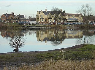
Gunthorpe is a village and civil parish in Nottinghamshire, England. Its population of 752 at the 2011 census was estimated at 559 in 2019. It lies on the left bank of the River Trent. Gunthorpe's on the A6097 is the only road bridge over the river between Newark and Nottingham.

Caunton is a village and civil parish in the Newark and Sherwood district of Nottinghamshire on the A616, six miles (9.7 km) north-west of Newark-on-Trent, in the NG23 postcode. The population of the civil parish at the 2011 Census was 483.

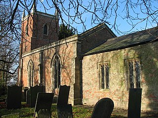
Sutton Cum Lound is a village located in Bassetlaw, north Nottinghamshire. It is located 3 miles from Retford. The civil parish is called Sutton. According to the 2001 census it had a population of 687, falling slightly to 673 at the 2011 census, and recovering to 683 at the 2021 census. The parish church of St Bartholomew is Norman, rebuilt in the Perpendicular style, with "unbridled curvilinear tracery" in the chancel windows. The village has a primary school. It borders the village of Barnby Moor which is about 1 mile away and is also very close to the village of Lound. The village has a number of public footpaths and walks such as those on Mire Hill.
Halam is a village and civil parish in the Newark and Sherwood district of Nottinghamshire, England, with a population of 372 in 2001, increasing to 426 at the 2011 Census. It is located to the west of Southwell.

Coddington is an English village and civil parish in Nottinghamshire, 3 miles (4.8 km) east of Newark-on-Trent. According to the 2001 census it had a population of 972, which increased to 1,684 at the 2011 Census and to 1,701 at the 2021 Census.

Holme is a village and civil parish in Nottinghamshire, England. The population of the civil parish at the 2011 Census was 165. It is located on the east of the River Trent, less than half a mile from the riverside and 4 miles north of Newark-on-Trent.

Fernwood is a village and civil parish in the Newark and Sherwood district of Nottinghamshire, England. The parish, which then included Balderton, had a population of 10,298 in 2001. It is a suburb of Newark-on-Trent.
Flawborough is a small hamlet and civil parish in the Rushcliffe borough of Nottinghamshire, England.

Staunton is a small village and civil parish in the Newark and Sherwood district of Nottinghamshire, England. It takes its name from the Vale of Belvoir and shares it with the local Staunton family, which has resided in the area since the Norman Conquest and possibly before, making them one of the English families living longest on its own estate.


