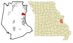
Barnhart, Missouri | |
---|---|
Coordinates: 38°20′09″N90°24′16″W / 38.33583°N 90.40444°W | |
Country | United States |
State | Missouri |
County | Jefferson |
Area | |
• Total | 5.26 sq mi (13.62 km2) |
• Land | 5.10 sq mi (13.21 km2) |
• Water | 0.16 sq mi (0.41 km2) |
Elevation | 554 ft (169 m) |
Population (2020) | |
• Total | 5,832 |
• Density | 1,143.31/sq mi (441.45/km2) |
Time zone | UTC-6 (Central (CST)) |
• Summer (DST) | UTC-5 (CDT) |
ZIP code | 63012 |
Area code | 636 |
FIPS code | 29-03394 [3] |
GNIS feature ID | 2393328 [2] |
Barnhart is a census-designated place (CDP) in Jefferson County, Missouri, United States. Barnhart is also a suburb of St. Louis.
The land surrounding Barnhart originally belonged to Benjamin O'Fallon, who settled here with his family in 1834. The James O'Fallon Home was built in 1860, and was purchased in 1884 by Joseph G. Marriott, a cattle rancher who introducing the first Holstein cattle to Jefferson County. The extant home is now called the Parkton Mansion. The town was not named until after the Frisco Railroad was completed in the early 1900s, and may have been named for Mrs. C. L. Barnhart, who donated land for the Frisco Railroad Depot. [4]
According to the United States Census Bureau, the CDP has a total area of 5.25 square miles (13.60 km2), of which 5.09 square miles (13.18 km2) is land and 0.16 square miles (0.41 km2) is water. [5]
Census | Pop. | Note | %± |
---|---|---|---|
2020 | 6,676 | — | |
U.S. Decennial Census [6] |
As of the census [7] of 2010, there were 5,682 people, 1,920 households, and 1,576 families living in the CDP. The population density was 1,116.3 inhabitants per square mile (431.0/km2). There were 2,003 housing units at an average density of 393.5 per square mile (151.9/km2). The racial makeup of the CDP was 97.4% White, 0.5% African American, 0.3% Native American, 0.4% Asian, 0.3% from other races, and 1.1% from two or more races. Hispanic or Latino of any race were 2.1% of the population.
There were 1,920 households, of which 44.0% had children under the age of 18 living with them, 65.3% were married couples living together, 10.8% had a female householder with no husband present, 6.0% had a male householder with no wife present, and 17.9% were non-families. 12.6% of all households were made up of individuals, and 2.7% had someone living alone who was 65 years of age or older. The average household size was 2.93 and the average family size was 3.17.
The median age in the CDP was 34.5 years. 27.6% of residents were under the age of 18; 8.1% were between the ages of 18 and 24; 28.8% were from 25 to 44; 28.5% were from 45 to 64; and 6.9% were 65 years of age or older. The gender makeup of the CDP was 50.4% male and 49.6% female.
As of the census [3] of 2000, there were 6,108 people, 1,962 households, and 1,663 families living in the CDP. The population density was 1,188.5 inhabitants per square mile (458.9/km2). There were 1,999 housing units at an average density of 389.0 per square mile (150.2/km2). The racial makeup of the CDP was 97.82% White, 0.36% African American, 0.13% Native American, 0.38% Asian, 0.02% Pacific Islander, 0.34% from other races, and 0.95% from two or more races. Hispanic or Latino of any race were 1.47% of the population.
There were 1,962 households, out of which 48.8% had children under the age of 18 living with them, 70.8% were married couples living together, 9.1% had a female householder with no husband present, and 15.2% were non-families. 11.2% of all households were made up of individuals, and 2.1% had someone living alone who was 65 years of age or older. The average household size was 3.08 and the average family size was 3.31.
In the CDP, the population was spread out, with 30.9% under the age of 18, 8.8% from 18 to 24, 34.4% from 25 to 44, 20.8% from 45 to 64, and 5.1% who were 65 years of age or older. The median age was 32 years. For every 100 females, there were 103.7 males. For every 100 females age 18 and over, there were 100.0 males.
The median income for a household in the CDP was $56,559, and the median income for a family was $59,189. Males had a median income of $41,758 versus $28,630 for females. The per capita income for the CDP was $20,940. About 0.9% of families and 2.6% of the population were below the poverty line, including none of those under age 18 and 6.5% of those age 65 or over.
Barnhart has a public library, a branch of the Jefferson County Library. [8]
Most of the Barnhart CDP is in the Windsor C-1 School District, while a portion of the CDP is in the Fox C-6 School District. [9] A southwestern portion of the wider Barnhart area is assigned to the Dunklin R-V School District. [10]
The Windsor district previously ended at the eighth grade. High school students would attend Crystal City High School or Herculaneum High School. [11] The Fox district was originally a K-8 school district, with high school students also having a choice of Crystal City High and Herculaneum High. The Fox district became K-12 when Fox High School was established in 1955. [12]
Moores Mill is an unincorporated community and census-designated place (CDP) in Madison County, Alabama, United States, and is included in the Huntsville-Decatur Combined Statistical Area. The population was 6,729 at the 2020 census, up from 5,682 at the 2010 census.
Hensley is a census-designated place (CDP) in Pulaski County, Arkansas, United States. The population was 139 at the 2010 census. It is part of the Little Rock–North Little Rock–Conway Metropolitan Statistical Area.
Windsor, formerly known as North Beach, is a gated community and census-designated place (CDP) on North Hutchinson Island in Indian River County, Florida, United States. The population was 256 at the 2010 census. It is part of the Sebastian–Vero Beach Metropolitan Statistical Area.
Terrytown is an unincorporated community and census-designated place (CDP) in Jefferson Parish, Louisiana, United States. It is on the "Westbank" of the Mississippi River. It is a suburb within the New Orleans–Metairie–Kenner metropolitan statistical area. The population was 23,319 at the 2010 census, and 25,278 in 2020.
HolcombHAW-kəm is a city in Dunklin County, Missouri, United States. The population was 635 at the 2010 census.
Herculaneum is a city in Jefferson County, Missouri, United States, and is a suburb of St. Louis. The population was 4,273 at the 2020 United States Census. The City of Herculaneum was the first county seat of Jefferson County from January 1, 1819 to 1839. The city celebrated its bicentennial throughout 2008.
High Ridge is an unincorporated community and census-designated place (CDP) in Jefferson County, Missouri, United States. The population was 4,305 at the 2010 census. At 927 feet (283 m) above sea level, High Ridge is the second-highest point in Jefferson County, second only to Sun Ridge, north of Hillsboro, according to data from the House Springs/Hillsboro 7.5 minute topographic quadrangles. The Beaumont Scout Reservation, a property of the Greater St. Louis Area Council, Boy Scouts of America, is 4 miles (6 km) north of High Ridge.
Horine is an unincorporated community and census-designated place (CDP) in Jefferson County, Missouri, United States. The population was 821 at the 2010 census, down from 923 in 2000.
Imperial is a census-designated place (CDP) in Jefferson County, Missouri, United States, and is a suburb of St. Louis. The population was 4,947 at the 2020 census. Imperial was originally known as West Kimmswick, the historic Catholic church of St. John’s in Imperial, became an independent parish in 1869.
Kimmswick is a city in Jefferson County, Missouri, United States. The population was 157 at the 2010 census.
Murphy is a census-designated place (CDP) in Jefferson County, Missouri, United States. The population was 8,690 at the 2010 census, down from 9,048 in 2000.
Pevely is a city in Jefferson County, Missouri, United States, and is also a suburb of St. Louis. The population was 6,107, at the 2020 United States Census.
Affton is a census-designated place (CDP) in south St. Louis County, Missouri, United States, near St. Louis. The population was 20,417 at the 2020 United States Census.
Hornersville is a city in Dunklin County, Missouri, United States, founded in 1840. The population was 537 at the 2020 census.
Plainsboro Center is an unincorporated community and census-designated place (CDP) located within Plainsboro Township, in Middlesex County, in the U.S. state of New Jersey. As of the 2010 United States Census, the CDP's population was 2,712.
Idylwood is a census-designated place (CDP) in Fairfax County, Virginia, United States. The population was 17,954 as of the 2020 census. It originally developed as a suburban community along the route of the Washington and Old Dominion Railroad, and later along Virginia State Route 7. The construction of the Capital Beltway in the 1960s, and I-66 and the Orange Line of the Washington Metrorail system in the 1980s, as well as the concurrent development of nearby Tysons Corner into Washington's leading suburban business district, led to the development of several apartment, townhouse, and small-lot single-family housing complexes, as well as the high-rise Idylwood Towers condominium, in the portion of Idylwood lying to the north of I-66. The area to the south of I-66 remains primarily large-lot single-family.
Jefferson is a census-designated place (CDP) in Kanawha County, West Virginia, United States, along the Kanawha River. The population was 676 at the 2010 census. Jefferson was incorporated on March 22, 1997, but was disincorporated less than a decade later on February 21, 2007.
Lake Koshkonong is a census-designated place (CDP) in the towns of Koshkonong and Sumner, Jefferson County, Wisconsin, United States. The population was 1,239 at the 2020 census. Lake Koshkonong is in the area.
New Windsor is a census-designated place (CDP) in the town of New Windsor in Orange County, New York, United States. The population was 8,882 at the 2020 census. It is part of the Poughkeepsie–Newburgh–Middletown, NY Metropolitan Statistical Area as well as the larger New York–Newark–Bridgeport, NY-NJ-CT-PA Combined Statistical Area.
Windsor is a village and former town in Dane County, Wisconsin. The population was 8,754 at the time of the 2020 census. The communities of Lake Windsor, Morrisonville, and Token Creek are located within the village. Windsor voted to incorporate as a village on November 3, 2015; prior to its incorporation, it was a town, and a portion of the town was a census-designated place. Windsor is a part of the Census Bureau's Madison metropolitan statistical area.