

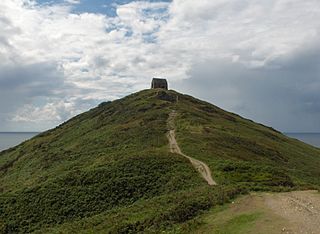
Bat's Head is a chalk headland on the Dorset coast in southern England, located between Swyre Head and Durdle Door to the east, and Chaldon Hill and White Nothe to the west. [1] [2] At the base of the headland is the small Bat's Cave.
Bat's Head is a chalk headland on the Dorset coast in southern England, located between Swyre Head and Durdle Door to the east, and Chaldon Hill and White Nothe to the west. [1] [2] At the base of the headland is the small Bat's Cave.

Durdle Door is a natural limestone arch on the Jurassic Coast near Lulworth in Dorset, England. Although privately owned by the Lulworth Estate, it is open to the public.

Dunnet Head is a peninsula in Caithness, on the north coast of Scotland. Dunnet Head includes the most northerly point of both mainland Scotland and the island of Great Britain.

Fistral Beach is in Fistral Bay on the north coast of Cornwall, England, United Kingdom. It is situated half-a-mile west of Newquay at grid reference SW 797 620.
Rame Head or Ram Head is a coastal headland, southwest of the village of Rame in southeast Cornwall, United Kingdom. It is part of the larger Rame Peninsula.
Eype Mouth is a natural break in a line of sea cliffs on the Jurassic Coast World Heritage Site in west Dorset on the south coast of England. The small River Eype drains into the sea at this point. Eype means 'a steep place' in Old English. The village of Eype lies just upstream of the rivermouth, which is reached by a single narrow lane which runs down through Lower Eype to a shingle beach with car park.

White Nothe is a chalk headland on the English Channel coast at the eastern end of Ringstead Bay, east of Weymouth in Dorset, England. The area is well known for its geology and fossils. Its flanks are the result of prehistoric landslides and the inaccessible slopes of the undercliff provide a secluded wildlife habitat.

Berry Head is a coastal headland that forms the southern boundary of Tor Bay in Devon, England. Lying to the east of the town of Brixham, it is a national nature reserve and a local nature reserve. Berry Head To Sharkham Point is a Site of Special Scientific Interest.

Zone Point is the southernmost extremity of the Roseland peninsula extending into Falmouth Bay near St Mawes in Cornwall, United Kingdom at grid reference SW8430.
The Rumps is a twin-headland promontory at the north-east corner of Pentire Head in north Cornwall, United Kingdom.
Dallam is a suburb of Warrington, England. It was historically in Lancashire but is now in Cheshire. It is home to a Royal Mail rail terminus on the main West Coast Main Line railway, opposite a large Eddie Stobart distribution centre. Most housing is former council housing. It is situated at the terminus of the Warrington Borough Transport number 16 and 16A bus routes.
Selsey Bill is a headland into the English Channel on the south coast of England in the county of West Sussex.

Man o' War Cove lies on the Dorset coast in southern England and is flanked by the rocky, steep and slightly projecting headlands of Durdle Door to the west and Man O War Head to the east.

Gurnard's Head is a prominent headland on the north coast of the Penwith peninsula in Cornwall, England, UK. The name is supposed to reflect that the rocky peninsula resembles the head of the gurnard fish.

Bowdun Head is a headland landform on the North Sea coast approximately one kilometre south of Stonehaven, Scotland.(Ordnance Survey, 2004) Slightly to the north is another headland, Downie Point. Somewhat to the south along the coast is Dunnottar Castle on the far side of the bay of Castle Haven. Other historic structures in the general vicinity include the Stonehaven Tolbooth, Fetteresso Castle, the Chapel of St. Mary and St. Nathalan and Muchalls Castle. There is considerable prehistory associated with the local area including a Pictish hill fort on the sea stack of Dunnicaer immediately to the north, and Bronze Age archaeological sites at Fetteresso and Spurryhillock, both somewhat inland of Bowdun Head.
Blurton is a district in the south of Stoke on Trent, in the English county of Staffordshire. Hollybush, Old Blurton, Blurton Farm and Newstead are the names of the areas in which make up the town known as Blurton.

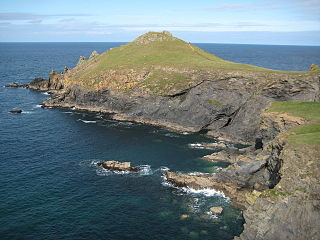
Gribbin Head is a promontory on the south coast of Cornwall, England, UK, owned and managed by the National Trust. It separates St Austell Bay from the estuary of the River Fowey and is marked by a large tower used to aid navigation of ships approaching the local harbours. The nearest town is Fowey. The western point of the headland is called Little Gribbin.

Towan Head is a headland one mile west of Newquay on the north coast of Cornwall, United Kingdom. It is at the western end of Newquay Bay. The headland points north and Fistral Beach is immediately to the south.

Kelsey Head is a coastal Site of Special Scientific Interest (SSSI) and headland in north Cornwall, England, UK, noted for its biological interest. The site contains an Iron Age hill fort.

Zennor Head is a 750-metre (2,460 ft) long promontory on the Cornish coast of England, between Pendour Cove and Porthzennor Cove. Facing the Atlantic Ocean, it lies 1 kilometre north-west of the village of Zennor and 1.6 kilometres east of the next promontory, Gurnard's Head. The granite (Killas) cliffs rise over 200 feet (60 m) from the sea and the highest point of the headland is 314 feet (96 m) above sea level, with an Ordnance Survey triangulation station. Zennor Head is on the South West Coast Path, which follows the cliff edge closely, skirting the entire perimeter of the headland. The promontory is part of the Penwith Heritage Coast, and is the largest coastal feature in the United Kingdom that begins with the letter "Z". It gets its name from a local saint, Senara. Zennor Head was mined for copper and tin in the Victorian Era. There is no longer any residential or commercial occupancy on the headland, but it is occupied by a variety of coastal animals and plants, such as kestrels and gorse.
Chaldon Hill, also called Chaldon Down, is one of the highest hills, 178 metres (584 ft), on South Dorset's Jurassic Coast in England. The summit is about 1.5 miles (2.4 km) west of Durdle Door.
Coordinates: 50°37′22″N2°17′28″W / 50.6227°N 2.2910°W
| | This Dorset location article is a stub. You can help Wikipedia by expanding it. |