Erastus Benson was a land speculator, investor and philanthropist who unsuccessfully ran for Mayor of Omaha in 1906. He was an early investor in marketing Thomas Edison's inventions, including the phonograph and the Kinetoscope.[1][2] In 1887, he purchased approximately 900 acres (3.6km2) of farm land from Edward Creighton, an Omaha businessman. On March 4, 1887, Benson platted the land on the Creighton farm and called it Benson Place, later changing it to Benson. The newly platted community was located along Military Avenue, approximately 9 miles (14km) northwest of Omaha.
In the mid-to-late 1910s, Omaha embarked on a course of annexations of suburban communities to its north and west. Residents of Benson, anticipating annexation of their own city, decided to build as many civic improvements as they could: they feared that Omaha would be inattentive to their desire for such improvements after annexation, and they knew that following annexation, the larger city would have to assume the debts incurred to build the improvements. To this end, they built a new combined city hall and fire station in late 1915.[3]
On May 25, 1917, the city of Omaha, Nebraska annexed the town of Benson. At that time, it was 1.4sqmi (3.6km2) and had 5000 residents.[4]
Krug Park was an amusement park located at 2936 North 52nd Street in Benson. In 1930 the park was the site of the worst roller coaster accident in the country to that year.[5]
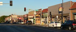
The Benson Commercial Historic District, centered along Maple St. between North 59th and North 63rd Sts., was listed on the U.S. National Register of Historic Places in 2020.[6]
Benson has many historic buildings, including commercial, governmental, educational and residential structures. The following, many within the historic district, are some of them:[3]
This page is based on this Wikipedia article Text is available under the CC BY-SA 4.0 license; additional terms may apply. Images, videos and audio are available under their respective licenses.