
The Iroquois National Wildlife Refuge is a wildlife refuge in Genesee and Orleans counties in western New York. The refuge is located between the cities of Buffalo and Rochester and is operated by the United States Fish and Wildlife Service.
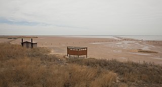
The Salt Plains National Wildlife Refuge is part of the United States system of National Wildlife Refuges. It is located in Alfalfa County in northern Oklahoma, north of Jet, along Great Salt Plains Lake, which is formed by a dam on the Salt Fork of the Arkansas River.
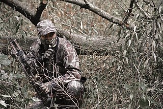
Bowhunting is the practice of hunting game animals by archery. Many indigenous peoples have employed the technique as their primary hunting method for thousands of years, and it has survived into contemporary use for sport and hunting.

The Sam Houston National Forest, one of four National Forests in Texas, is located 50 miles north of Houston. The forest is administered together with the other three United States National Forests and two National Grasslands located entirely in Texas, from common offices in Lufkin, Texas. The units include Angelina, Davy Crockett, Sabine, and Sam Houston National Forests, plus Caddo National Grassland and Lyndon B. Johnson National Grassland. There are local ranger district offices located in New Waverly.

Deer hunting is meat hunting or sport hunting for deer, which dates back tens of thousands of years. Venison, or deer meat, is a highly nutritious and natural form of animal protein that can be obtained through deer hunting. There are many types of deer around the world that are hunted for their meat.

Marsh Creek State Park is a 1,705 acres (690 ha) Pennsylvania state park in Upper Uwchlan and Wallace Townships, Chester County, Pennsylvania in the United States. The park is the location of the 535-acre (217 ha) man-made Marsh Creek Lake. With an average depth of 40 feet, the lake is stocked with fish and is a stop for migrating waterfowl. Marsh Creek State Park is 2 miles (3.2 km) west of Eagle on Pennsylvania Route 100. Park road hours 8:00 am until sunset. All other access open 24 hours.

Mt. Pisgah State Park is a 1,302-acre (527 ha) Pennsylvania state park in Smithfield, Springfield, Troy and West Burlington Townships, Bradford County, Pennsylvania in the United States. The park is located almost exactly halfway between Troy and Towanda, along Pennsylvania State Route 3019, near U.S. Route 6, at the base of Mt. Pisgah. The park is bordered by Mill Creek, Mt. Pisgah County Park and State Game Land 289. Mill Creek which flows through the park has been dammed and forms Stephen Foster Lake a 75-acre (30 ha) man-made lake.
The crossbow often has a complicated legal status due to its potential use for lethal purposes, and its similarities with both firearms and other archery weapons. The crossbow is, for technical purposes, often categorized as a firearm by various legal jurisdictions, despite the fact that no combustion is required to propel the projectile.
A bag limit is a law imposed on hunters and fishermen restricting the number of animals within a specific species or group of species they may kill and keep. Size limits and hunting seasons sometimes accompany bag limits which place restrictions on the size of those animals and the time of year during which hunters may legally kill them. Those who violate these laws or other hunting laws are known as poachers.
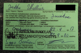
A hunting license is a regulatory or legal mechanism to control hunting.

Des Plaines Fish and Wildlife Area is an Illinois state park on 5,000 acres (2,023 ha) in Will County, Illinois, United States. It is located on floodplain adjacent to the confluence of the Des Plaines River and the Kankakee River to form the Illinois River.

Chester F. Phelps Wildlife Management Area is a 4,539-acre (18.37 km2) Wildlife Management Area located in Fauquier and Culpeper counties, Virginia. It contains over 1,000 acres (4 km2) of open land previously used for agriculture; additional open areas may be found within the forests on the property. Most of the terrain is rolling, low, and shallow; the steepest land can be seen near the Rappahannock River, which forms a large part of the property's western border. A number of small streams cross the land, and a three-acre (12,000 m2) pond is located near its center. The forests on the property contain both pine and hardwood.

Cavalier Wildlife Management Area is a 4,550-acre (18.4 km2) Wildlife Management Area in Chesapeake, Virginia. It preserves habitat for a number of species, including black bear, canebrake rattlesnakes, white-tailed deer, eastern wild turkeys, and many varieties of songbirds.

Young Conservation Area, formerly named Hilda Young Conservation Area, consisting of 970 acres (3.9 km2), is located in the north central portion of Jefferson County, Missouri. The property is about 3 miles (4.8 km) west of County Highway W along Highway FF between LaBarque Creek and John McKeever Road.

Green Bottom Wildlife Management Area is located on former plantation lands of U.S. Congressman and Confederate General Albert G. Jenkins. The 1,096 acres (444 ha) in Cabell County and Mason County are located along the banks of the Ohio River about 16 miles (26 km) north of Huntington, West Virginia. The Green Bottom WMA land is a mixture of farmland, mixed hardwood forest, wetlands, and open water. The Jenkins Plantation Museum is located on Corps of Engineers land adjacent to the WMA. The museum is located in the original 1835 Green Bottom Plantation House, and is operated by the West Virginia Division of Culture and History.

Lake Sugema [Pronounced sōō•jē’•mə](+40° 41' 22.85", -91° 59' 39.01") is a man-made 574-acre (2.32 km2) lake 3 miles (4.8 km) southwest of Keosauqua, Van Buren County, in southeast Iowa, United States. It is located south of the Des Moines River, west of State Highway 1 and north of State Highway 2.
Willow Slough Fish and Wildlife Area is an area dedicated to providing hunting and fishing opportunities while maintaining 9,956 acres (40.29 km2), 1,800 of which are open water, marshes, and flooded crop land. It is located at 2042 S. 500 W., Morocco, Indiana.

August A. Busch Memorial Conservation Area is a 6,987-acre (28.28 km2) conservation area that is owned and managed by the Missouri Department of Conservation. Located in St. Charles County, Missouri, the land was purchased by the Department of Conservation with help from Alice Busch, the wife of August Anheuser Busch, Sr., in 1947 from the U.S. Government.
Howell Island Conservation Area protected area covering 2,547 acres (10.31 km2) and managed by the Missouri Department of Conservation on Howell Island located in the Missouri River in Boone Township, St. Charles County, Missouri, although the MDOC land surrounding the parking area is in St. Louis County. The island is bounded by the Missouri River on the north side and Centaur Chute to the south. The island is mostly forested in bottomland trees such as sycamore and cottonwood.
The Sahara Woods State Fish and Wildlife Area is a 4,100-acre (1,700 ha) state park owned and operated by the Illinois Department of Natural Resources (IDNR). It is located in Saline County, five miles west of the small city of Harrisburg.


