Redgrave and Lopham Fens is a 127 hectare biological Site of Special Scientific Interest between Thelnetham in Suffolk and Diss in Norfolk. England. It is a national nature reserve, a Ramsar internationally important wetland site, a Nature Conservation Review site, Grade I, and part of the Waveney and Little Ouse Valley Fens Special Area of Conservation. It is managed by the Suffolk Wildlife Trust.
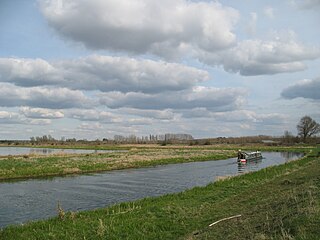
The River Little Ouse, also known as the Brandon River, is a river in the east of England, a tributary of the River Great Ouse. For much of its length it defines the boundary between Norfolk and Suffolk.

Ouse Washes is a linear 2,513.6-hectare (6,211-acre) biological Site of Special Scientific Interest stretching from near St Ives in Cambridgeshire to Downham Market in Norfolk, England. It is also a Ramsar internationally important wetland site, a Special Protection Area for birds, a Special Area of Conservation and a Nature Conservation Review site, Grade I. An area of 186 hectares between March and Ely is managed by the Wildlife Trust for Bedfordshire, Cambridgeshire and Northamptonshire and another area near Chatteris is managed by the Royal Society for the Protection of Birds. The Wildfowl & Wetlands Trust manages another area near Welney.
Knettishall Heath is a 91.7-hectare (227-acre) biological Site of Special Scientific Interest west of Knettishall in Suffolk, England. A larger area of 176 hectares is the Knettishall Heath Nature Reserve, which is managed by the Suffolk Wildlife Trust.

Cladium is a genus of large sedges, with a nearly worldwide distribution in tropical and temperate regions. These are plants characterized by long, narrow (grass-like) leaves having sharp, often serrated (sawtooth-like) margins, and flowering stems 1–3 m tall bearing a much-branched inflorescence. Like many plants found in wet habitats, it has deeply buried rhizomes that can produce tall shoots with dense canopies.

Suffolk Wildlife Trust (SWT) describes itself as the county's "nature charity – the only organisation dedicated wholly to safeguarding Suffolk's wildlife and countryside." It is a registered charity, and its headquarters is at Brooke House in Ashbocking, near Ipswich. It was founded in 1961, and is one of 46 wildlife trusts covering Great Britain and Northern Ireland. As of March 2017, it has 13,200 members, and it manages 3,120 hectares of land in 60 nature reserves, most of which are open to the public. It had an income of £3.9 million in the year to 31 March 2017.

Blo' Norton is a village and civil parish in the Breckland district of the English county of Norfolk.
Yanal Bog is a 1.6 hectare biological Site of Special Scientific Interest on the southern edge of the North Somerset Levels, just north of the village of Sandford, North Somerset. It was notified as an SSSI in 1988.

The Angles Way is a long-distance footpath in England, close to the River Waveney and River Little Ouse and thus close to the Norfolk/Suffolk border between Great Yarmouth and Thetford.
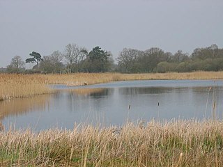
The Little Ouse Headwaters Project (LOHP) was set up in 2002 by local residents to promote conservation and enjoyment of the fenland habitats bordering the upper reaches of the River Little Ouse, which lies on the Norfolk-Suffolk border. The site lies between Blo' Norton in Norfolk and Thelnetham in Suffolk. It includes a number of areas including Hinderclay Fen, Blo' Norton Fen, Betty's Fen, The Frith, Blo' Norton Lowes, Blo' Norton Little Fen and Parker's Piece. The area also include parts of the Blo' Norton and Thelnetham Fen Site of Special Scientific Interest (SSSI).

Hinderclay is a village and civil parish in the Mid Suffolk district of Suffolk in eastern England. The village is located around 14 miles (23 km) - from Bury St Edmunds in an area of rolling arable land to the south of the Little Ouse river valley. Neighbouring villages include Thelnetham and Rickinghall. In 2005 its population was 340. The parish also contains the hamlet of Thorpe Street.

Thelnetham is a village and civil parish in the West Suffolk district of Suffolk in eastern England. Located on the southern bank of the River Little Ouse, six miles west of Diss, in 2005 its population was 230. The village of Blo' Norton lies on the Norfolk side of the river. The name of the village derives from the Old English words "thel" which means a plank bridge, "elfitu" meaning swans and "hamm" meaning a meadow or enclosure. Hence the village is the "meadow with the plank bridge and the swans".
Flixton is a village and civil parish located in the north of the English county of Suffolk. It is around 2 miles (3.2 km) south-west of Bungay in the East Suffolk district and is one of the villages around Bungay which make up the area known as The Saints. The A143 road runs just to the north of the parish border linking Bungay with Harleston and Diss.

Hell Kettles is a Site of Special Scientific Interest in the Darlington district of County Durham, England. It was designated for its biological interest as the only site in County Durham where there is a body of water fed by springs.
Cladium mariscus is a species of flowering plant in the sedge family known by the common names swamp sawgrass, great fen-sedge, saw-sedge or sawtooth sedge. Previously it was known as elk sedge. It is native of temperate Europe and Asia where it grows in base-rich boggy areas and lakesides. It can be up to 2.5 metres tall, and has leaves with hard serrated edges. In the past, it was an important material to build thatched roofs; harvesting it was an arduous task due to its sharp edges that can cause deep lacerations.

Barnby Broad and Marshes is a Site of Special Scientific Interest (SSSI) in the Waveney district of the English county of Suffolk. The site is 189.6 hectares in size. It is in the parishes of North Cove and Barnby, located between Beccles and Lowestoft in the north of the county. The site is bordered on its southern edge by the East Suffolk railway line and to the north by the River Waveney. It is a Special Area of Conservation, a Special Protection Area under the EC Birds Directive, and a Ramsar internationally important wetland site. There are two Suffolk Wildlife Trust nature reserves in the site, Castle Marshes and North Cove.

Bugg's Hole Fen is a 3.7-hectare (9.1-acre) biological Site of Special Scientific Interest north-west of Thelnetham in Suffolk.

Weston Fen is a 49.7-hectare (123-acre) biological Site of Special Scientific Interest in Hopton in Suffolk. It is part of the Waveney and Little Ouse Valley Fens Special Areas of Conservation, and an area of 37 hectares is managed as a nature reserve called Market Weston Fen by the Suffolk Wildlife Trust.
Ballynafagh Lake is a Special Area of Conservation and wildfowl sanctuary in County Kildare, close to the town of Prosperous in County Kildare, Ireland. This site is also known as the Blackwood Reservoir, the Blackwood Lake or the Prosperous Reservoir.
