
Milton Keynes is the largest settlement in Buckinghamshire, England, 50 miles (80 km) north-west of London. At the 2011 Census, the population of its urban area was almost 230,000. The River Great Ouse forms its northern boundary; a tributary, the River Ouzel, meanders through its linear parks and balancing lakes. Approximately 25% of the urban area is parkland or woodland and includes two Sites of Special Scientific Interest (SSSIs).

The Borough of Milton Keynes is a unitary authority and borough of the ceremonial county of Buckinghamshire. It is the northernmost district of the South East England Region. It was originally one of five non-metropolitan districts of Buckinghamshire, but on 1 April 1997, under a recommendation of the Local Government Commission for England, it became a self-governing non-metropolitan county, independent from Buckinghamshire County Council.
Calvert is a village in Buckinghamshire, England, near the village of Steeple Claydon.

Bletchley is a constituent town of Milton Keynes, Buckinghamshire, England. It is situated in the south-west of Milton Keynes, and is split between the civil parishes of Bletchley and Fenny Stratford and West Bletchley.
Newton Longville is a village and civil parish in the unitary authority area of Buckinghamshire, England. The village is about 2 miles (3 km) south-west of Bletchley.

Water Eaton is an area of Milton Keynes, Buckinghamshire, England and in the civil parish of Bletchley and Fenny Stratford. It is to the south of, and contiguous with, Fenny Stratford. It is one of the ancient Buckinghamshire villages that became incorporated as part of Milton Keynes in 1967.

The Cotswold Water Park is the United Kingdom's largest marl lake system, straddling the Wiltshire–Gloucestershire border, northwest of Cricklade and south of Cirencester. There are 180 lakes, spread over 42 square miles (110 km2).

The National Bowl is an entertainment venue located in Milton Keynes, Buckinghamshire, England. The site was a former clay-pit, filled in and raised to form an amphitheatre using sub-soil excavated by the many new developments in the area. It has a maximum capacity of 65,000. The arena is open-air grassland, without seats.

Lidlington is a small village and civil parish in Central Bedfordshire, England surrounded by farmland, in the Marston Vale. The hamlets of Boughton End and Thrupp End are also part of the parish.

Arlesey is a town and civil parish in Bedfordshire. It is near the border with Hertfordshire, about three miles north-west of Letchworth Garden City, four miles north of Hitchin and six miles south of Biggleswade. Arlesey railway station provides services to London, Stevenage and Peterborough. The Domesday Book mentions Arlesey. The town's name means the 'island of a man/woman named Aelfric'.
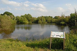
Rixton Clay Pits is a former clay extraction site in Rixton, near Hollins Green, Warrington, England. Formerly farmland, boulder clay extraction started in the 1920s for brick making in the adjacent brickworks, and ceased in 1965 - since then it has been allowed to return to nature. It is now an area of ponds, scrub, woodland and damp grassland. It is owned and managed by Warrington Borough Council as a local amenity.

West Bletchley is a district and civil parish that covers the western part of Bletchley, a constituent town of Milton Keynes in Buckinghamshire, England. The parish consists of that part of Bletchley which is south of Standing Way (A421), west of the West Coast Main Line, and north of Water Eaton Brook..

Bletchley and Fenny Stratford is a civil parish with a town council, in Milton Keynes, Buckinghamshire, England. It was formed in 2001 from the unparished area of Milton Keynes, and according to the 2011 census had a population of 15,313. Together with West Bletchley, it forms the Bletchley built-up area.
Sport in Milton Keynes covers a range of professional and amateur sport in the Borough of Milton Keynes. In 2019, Milton Keynes was officially designated as a European City of Sport for 2020. There are professional teams in football, in motorsport and in ice hockey. The National Badminton Centre, and the Marshall Milton Keynes Athletic Club train professional and amateur athletes. Most other sports feature at amateur level although there are semi-professional teams in rugby union and football among other sports. There is an international-standard karting track owned by Daytona Motorsport.
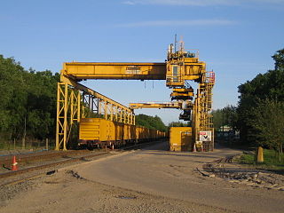
The London Brick Company, owned by Forterra plc, is a leading British manufacturer of bricks.

This history of Milton Keynes details its development from the earliest human settlements, through the plans for a 'new city' for 250,000 people in northern Southeast England, its subsequent urban design and development, to the present day. Milton Keynes is the largest settlement in Buckinghamshire, founded in 1967. At the 2011 census, the population of its urban area was estimated to have reached almost 230,000.
Newton Leys is a district that covers the southern tip of Bletchley and straddles the boundary between the Borough of Milton Keynes and the rest of Buckinghamshire. The larger fraction of Newton Leys lies within Milton Keynes and forms a part of Bletchley and Fenny Stratford civil parish. It is separated from central Bletchley, Water Eaton and the Lakes Estate by the West Coast Main Line. The remaining fraction of Newton Leys lies within the (former) Aylesbury Vale district and forms a part of the Stoke Hammond civil parish, although the village of Stoke Hammond is situated on the other side of the A4146
Simpson and Ashland is a civil parish in the south of Milton Keynes in Buckinghamshire, England.

The Bletchley Flyover was originally a reinforced concrete railway viaduct that carried the former Varsity line between Oxford and Cambridge over the West Coast Main Line (WCML) at Bletchley railway station in Milton Keynes, England. It was retained but largely unused when the line closed until it was demolished in late 2020 and early 2021. As of May 2021, a new structure is being built for use by East West Rail, in the form of a box tunnel around the WCML.
