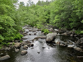
The Blackwater River is a 37.5-mile-long (60.4 km) river located in central New Hampshire in the United States. It is a tributary of the Contoocook River, part of the Merrimack River watershed.

The Mount Orne Bridge is a covered bridge over the Connecticut River between Lancaster, New Hampshire, and Lunenburg, Vermont. It joins Elm Street in South Lancaster with River Road in Lunenburg. Built in 1911, it is one of two Howe truss bridges across the Connecticut River. It was listed on the National Register of Historic Places in 1976.

The Bedell Bridge was a Burr truss covered bridge that spanned the Connecticut River between Newbury, Vermont and Haverhill, New Hampshire. Until its most recent destruction in 1979, it was, with a total length of 382 feet (116 m), the second-longest covered bridge in the United States. The bridge was divided into two spans of roughly equal length, and rested on a central pier and shore abutments constructed from mortared rough stone. The eastern abutment has been shored up by the addition of a concrete footing. The bridge was 23 feet (7.0 m) wide, with a roadway width of 18.5 feet (5.6 m). Because the state line is the western low-water mark of the Connecticut River, most of the bridge was in New Hampshire; only the western abutment is in Vermont.

The East Fairfield Covered Bridge is a covered bridge that carries Bridge Street across Black Creek in the East Fairfield village of Fairfield, Vermont. Built about 1865, it is the town's only surviving 19th century covered bridge. It was listed on the National Register of Historic Places in 1974.

The Coombs Covered Bridge is a wooden covered bridge which carries Coombs Bridge Road over the Ashuelot River in northern Winchester, New Hampshire. It was built in 1843, and is one of the state's small number of surviving 19th-century covered bridges. It was listed on the National Register of Historic Places in 1976.

The Carlton Bridge is a historic wooden covered bridge that carries Carlton Road over the South Branch Ashuelot River in East Swanzey, New Hampshire. The bridge was built in 1869, and is the region's only surviving example of a 19th-century Queenspost truss bridge. The bridge was listed on the National Register of Historic Places in 1975.

The Ashuelot Covered Bridge is a historic wooden covered bridge over the Ashuelot River on Bolton Road, just south of its intersection with NH 119 in Ashuelot, an unincorporated village of Winchester, New Hampshire. Built in 1864-65, it is one of the state's few surviving 19th-century covered bridges. It was listed on the National Register of Historic Places in 1981.
The Cold River Bridge, also known as McDermott Bridge, is a historic wooden covered bridge spanning the Cold River near Crane Brook Road in Langdon, New Hampshire, USA. Built in 1869, it is one of the state's few surviving 19th-century covered bridges. It was listed on the National Register of Historic Places in 1973. It is closed to vehicular traffic.

The Bement Covered Bridge is a historic wooden covered bridge on Center Road over the Warner River in Bradford, New Hampshire. A Long-truss bridge, it was built in 1854, and is one of New Hampshire's small number of surviving 19th-century covered bridges. It was listed on the National Register of Historic Places in 1976.

The Whittier Bridge is a historic wooden covered bridge in Ossipee, New Hampshire. The bridge carried an old alignment of New Hampshire Route 25 over the Bearcamp River. Built in 1870, it is one of New Hampshire's few surviving 19th-century covered bridges, and a rare example of a Paddleford truss. The bridge was listed on the National Register of Historic Places in 1984. It was closed to vehicular traffic in 1989, and was removed from its footings for restoration in 2008. As of September 2019, the bridge is resting on Nudd Road adjacent to the crossing point. It was placed back on its abutments in the late fall of 2022.

The Swiftwater Covered Bridge is a historic covered bridge which carries Porter Road over the Wild Ammonoosuc River in Bath, New Hampshire. Built in 1849, it is one of New Hampshire's few surviving 19th-century covered bridges, and a well-preserved example of the Paddleford truss design. The bridge was added to the National Register of Historic Places in 1976.

The Contoocook Railroad Bridge is a covered bridge on the former Contoocook Valley Railroad line spanning the Contoocook River in the center of the village of Contoocook, New Hampshire, United States. It is referred to in the National Register of Historic Places as the Hopkinton Railroad Covered Bridge, for the town of Hopkinton, New Hampshire, in which the village of Contoocook is located.
The Northfield Falls Covered Bridge, also called the Station Covered Bridge, is a wooden covered bridge that carries Cox Brook Road across the Dog River in Northfield, Vermont. Built in 1872, this Town lattice truss bridge is one of five surviving covered bridges in the town, and one of two that are visible from each other. It was listed on the National Register of Historic Places in 1974.

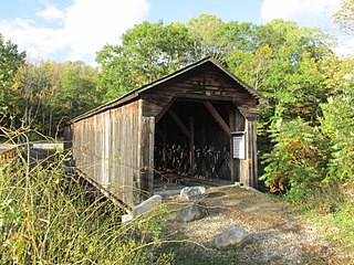
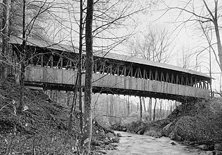
The Keniston Bridge is a historic covered bridge in Andover, New Hampshire, carrying Bridge Street over the Blackwater River. Built in 1882, it is of Town through truss construction, and is one of the few surviving 19th-century covered bridges in the state. It is also one of the only ones whose sides are not fully sheathed, exposing the trusses. The bridge was listed on the National Register of Historic Places in 1989.
The Durgin Bridge is a covered bridge carrying Durgin Bridge Road over the Cold River in eastern Sandwich, New Hampshire. Built in 1869, it is a rare surviving example of a Paddleford truss bridge, and one of the few surviving 19th-century covered bridges in New Hampshire. It was listed on the National Register of Historic Places in 1983.

The Dingleton Hill Covered Bridge, also known as the Cornish Mills Bridge, is a historic wooden covered bridge, carrying Root Hill Road over Mill Brook in Cornish Mills, New Hampshire. Built in 1882, it is one of the state's few surviving 19th-century covered bridges. It was listed on the National Register of Historic Places in 1978. It carries one lane of traffic, with a posted weight limit.
The Kenyon Bridge, also known as the Blacksmith Shop Bridge, is a historic covered bridge spanning Mill Brook near Town House Road in Cornish, New Hampshire, United States. Built in 1882, it is one of New Hampshire's few surviving 19th-century covered bridges. It was listed on the National Register of Historic Places in 1978.
The Howe Covered Bridge is a historic covered bridge carrying Belknap Brook Road across the White River in Tunbridge, Vermont, just east of Vermont Route 110. Built in 1879, it is one of five surviving bridges in the town, one of the highest concentrations of covered bridges in the state. It was listed on the National Register of Historic Places in 1974.

The Greenbanks Hollow Covered Bridge is a historic covered bridge built in 1886, carrying Greenbanks Hollow Road across Joes Brook in southern Danville, Vermont. It is the only surviving 19th-century covered bridge in the town. It was listed on the National Register of Historic Places in 1974.

The Lyme–East Thetford Bridge is a historic bridge over the Connecticut River between Lyme, New Hampshire, and East Thetford, Vermont. From the New Hampshire side it carries East Thetford Road, which becomes Vermont Route 113 as it enters Vermont. A Parker truss bridge completed in 1937, it is 471 feet (144 m) long. The bridge was added to the National Register of Historic Places in 2020.


