
The New Hampshire Farm Museum is a farm museum on White Mountain Highway in Milton, New Hampshire, United States. Three centuries of New Hampshire rural life are presented in the historic farmhouse. The museum includes a 104-foot-long (32 m) three-story great barn with collection of agricultural machinery, farm tools, sleighs and wagons. There are also live farm animals, a nature trail and a museum shop. The museum is located on the former Plumer-Jones Farm, a traditional series of connected buildings with farmhouse dating to the late 18th century and barns dating to the mid 19th century, which was listed on the National Register of Historic Places in 1979.
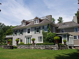
Chesterwood was the summer estate and studio of American sculptor Daniel Chester French (1850–1931) located at 4 Williamsville Road in Stockbridge, Massachusetts. Most of French's originally 150-acre (61 ha) estate is now owned by the National Trust for Historic Preservation, which operates the property as a museum and sculpture garden. The property was designated a National Historic Landmark in 1965 in recognition of French's importance in American sculpture.

The Harrisville Rural District in Harrisville, New Hampshire was listed on the National Register of Historic Places in 1987. The district encompasses a large area in the central southern part of the town, where much of its early development took place. Its westernmost public point is the corner of Mason and Macveagh Roads, and it extends eastward from there, encompassing properties that abut Mason, Venable, and New Harrisville Roads south to the town line with Dublin. Further east it encompasses properties on Bonds Corner Road between Eastview and Lampman Roads, as well as some property on the north side of Lampman Road. The district includes existing houses and outbuildings as well as foundational and archaeological remnants of previous early settlement structures. A portion of the district along New Harrisville and Venable Roads is overlaid by the Beech Hill Summer Home District.
The Coleman Station Historic District is located around the former New York Central Railroad Coleman's station in the Town of North East, New York, United States, a short distance south of the village of Millerton. It is a rural area including several large farms in the southeastern corner of the town. At almost three square miles (7.33 km2), it is the largest historic district entirely within Dutchess County and the second largest in the county.

True Farm is a historic farm and summer estate in Holderness, New Hampshire. Located off New Hampshire Route 113 on True Farm Road, the farm is based around a c.1820 farmhouse, and was expanded into a summer estate in 1920 by George Saltonstall West. The 100-acre (40 ha) estate includes numerous outbuildings and a lakefront cottage. The farm was listed on the National Register of Historic Places in 2012.

The Buckminster-Kingsbury Farm is a historic farmhouse at 80 Houghton Ledge Road in Roxbury, New Hampshire. The brick house was built c. 1825, and is a well-preserved example of vernacular Federal and Greek Revival styling. The house was listed on the National Register of Historic Places in 2011.

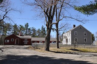
Lovett's by Lafayette Brook, or Lovett's Inn, is a historic farmstead and inn at 1474 Profile Road in Franconia, New Hampshire, United States. It is one of a few surviving early 20th century hostelries in the state, dating to a period when many large and more elaborate hotels stood that have succumbed to fire or demolition. It is located on the west side of Profile Road, in a rural area between the village center of Franconia and Cannon Mountain. The building was listed on the National Register of Historic Places in 1982. It continues to function as a small hotel with restaurant.

The Frost Farm is a historic farmstead at 18 Fairwood Drive in Dublin, New Hampshire, United States. Built in 1855 and extensively restyled in 1910, it is a good example of a Georgian Revival summer house, with expansive views of nearby Mount Monadnock. The property was listed on the National Register of Historic Places in 1983. It is now home to the Fairwood Bible Institute.

Spring Hill Farm is a historic farm at 263 Meriden Road in Lebanon, New Hampshire. Founded in the late 18th century, the farm is noted for innovations in dairy farming practices introduced in the 1920s by Maurice Downs. It is also one of a small number of surviving farm properties in the town, and was listed on the National Register of Historic Places in 2002.
The Asa Morse Farm, also known as the Friendly Farm, is a historic farmstead on New Hampshire Route 101 in Dublin, New Hampshire. The main farmhouse, built in 1926 on the foundations of an early 19th-century house, is a good example of Colonial Revival architecture, built during Dublin's heyday as a summer retreat. The farmstead was listed on the National Register of Historic Places in 1983.

The Chocorua Lake Basin Historic District is a large historic district surrounding Chocorua Lake in the town of Tamworth in New Hampshire, United States. It includes more than 6,000 acres (2,400 ha), with the lake roughly at its center, extending from Washington Hill Road in the east to Fowles Mill Road and Philbrick Neighborhood Road in the west, and from the town line with Albany in the north to Heavenly Hill Road in the south. The district's significance derives from a large cluster of late 19th and early 20th century summer resort houses built around and near the lake, and the role the area's landowners have played in the conservation of the lake and viewsheds associated with it and nearby Mount Chocorua. The district was listed on the National Register of Historic Places in 2005.

The Kennedy Hill Farm is a historic farmstead on Kennedy Hill Road in Goffstown, New Hampshire. The property exhibits 150 years of agricultural history, with a well-crafted c. 1800 farmhouse built using regionally distinctive joinery skills. The property was listed on the National Register of Historic Places in 1984.
The New Ipswich Center Village Historic District encompasses the historic center of the rural town of New Ipswich, New Hampshire. The center village is the town's most densely populated area, with a history dating to the town's founding in 1735. The district extends along Turnpike Road between King and Porter Roads, and southward in a roughly triangular shape, the southern point of which is at the junction of Main Street and Willard Road. The village includes a large number of residences, which were mainly agricultural at first, but also include a number of properties built as summer resort houses in the late 19th and early 20th centuries. It also includes most of the town's historic civic buildings, including its historic town hall, and the Barrett House, now a museum property owned by Historic New England. The district was listed on the National Register of Historic Places in 1991.

Stonyfield Farm, also known as the Ebenezer Barrett Farm, is a historic farm on Barrett Hill Road in Wilton, New Hampshire. Established in 1803 by Ebenezer Barrett, the farm layout and buildings represent a well-preserved example of a rural hill country farm of the 19th century, which survived in part by being transformed into a gentleman's farm in the early 20th century. It is on this farm that noted yogurt maker Stonyfield Farm was founded. The farm was listed on the National Register of Historic Places in 1983.

Elm Farm, alsk known as the Sargent Farm, is a historic farm property at 599 Main Street in Danville, New Hampshire. Established about 1835, it has been in agricultural use since then, with many of its owners also engaged in small commercial or industrial pursuits on the side. The main farmhouse is one of the town's best examples of Gothic Revival architecture. The property was listed on the National Register of Historic Places in 1988.

The Parker Hill Rural Historic District encompasses a large rural agricultural landscape in eastern Windham and Windsor counties in the US state of Vermont. Roughly centered on Parker Hill Road in northern Rockingham and southern Springfield, the district exhibits a history of 200 years of farming, including a collection of Federal period farm housing. The district was listed on the National Register of Historic Places in 1993.
The Rural Otter Creek Valley Historic District encompasses a rural agricultural area of southern Wallingford, Vermont. It includes nine past and present farmsteads along a stretch of United States Route 7 in the Otter Creek valley, with an agricultural history dating to the early decades of the 19th century. The district was listed on the National Register of Historic Places in 1987.

Top Acres Farm, known historically as the Fletcher–Fullerton Farm, is a farm property at 1390 Fletcher Schoolhouse Road in Woodstock, Vermont. Developed as a farm in the early 19th century, it was in continuous agricultural use by just two families for nearly two centuries. It was listed on the National Register of Historic Places in 2004.

Saddlebow Farm is a historic farm property at 2477 Gold Coast Road in Bridgewater, Vermont. With a history dating to the 1780s, the property is a fine example of the conversion of agricultural properties to summer and tourist-oriented uses in the 20th century. The 140-acre (57 ha) property was listed on the National Register of Historic Places in 2002.

The Oxbow Historic District encompasses a well-preserved rural agricultural area on United States Route 5 in northern Newbury, Vermont. It was one of the first areas to be settled in the town, and includes seven agricultural properties, with six farmhouses built before 1835 and a number of surviving 19th-century farm outbuildings. It was listed on the National Register of Historic Places in 1983.


