Boram block

Last updated
Boram
Community development block
Dimna Lake, Jamshedpur.jpg
Dimna Lake in Boram block - Dalma Hills in the background
India Jharkhand location map.svg
Red pog.svg
Boram
Location in Jharkhand
India location map 3.png
Red pog.svg
Boram
Boram (India)
Coordinates: 22°57′24″N86°17′04″E / 22.9568°N 86.2844°E / 22.9568; 86.2844 Coordinates: 22°57′24″N86°17′04″E / 22.9568°N 86.2844°E / 22.9568; 86.2844
CountryFlag of India.svg  India
State Jharkhand
District East Singhbhum
Government
  Type Federal democracy
Area
  Total244.41 km2 (94.37 sq mi)
Population
 (2011)
  Total69,013
  Density280/km2 (730/sq mi)
Languages
   Official Hindi, Urdu
Time zone UTC+5:30 (IST)
PIN
832112
Telephone/STD code0657
Vehicle registration JH 05
Literacy58.02%
Lok Sabha constituency Jamshedpur
Vidhan Sabha constituency Jugsalai
Website jamshedpur.nic.in

Boram block is a CD block that forms an administrative division in the Dhalbhum subdivision of East Singhbhum district, in the Indian state of Jharkhand.

Contents

History

The laying of the foundation stone of the steel plant by Tata Steel (then known as Tata Iron and Steel Company) in 1907 at Sakchi Kalimati in Singhbhum district marked the beginning of the industrialisation of the area. The first police station in the area was opened in 1912 at Jugsalai. The Kalimati Sakchi village was renamed ‘Jamshedpur’ in 1917. Dhalbhum subdivision was created in 1920 with Jamshedpur as headquarters. Jamshedpur Notified Area was established in 1924. East Singhbhum district, with Jamshedpur as headquarters, was set up in 1990. [1]

Geography

Boram is located at 22°57′24″N86°17′04″E / 22.9568°N 86.2844°E / 22.9568; 86.2844 .

“The district forms a part of the Chota Nagpur Plateau and is a hilly upland tract”. The Seraikela Dhalbhumgarh upland and the Dalma range are natural divisions of the district. The main rivers are the Subarnarekha and the Kharkai. [2]

The district consists of two subdivisions - (1) Dhalbhum subdivision with Patamda, Boram, Golmuri-cum-Jugsalai and Potka CD blocks, and (2) Ghatshila subdivision with Ghatshila, Dhalbhumgarh, Musabani, Dumaria, Gurbandha, Chakulia and Baharagora CD blocks. [3]

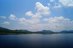
Dimna Lake was constructed by Tata Steel in Boram block. [4]

Boram CD block is bounded by the Barabazar CD block in the Purulia district of the West Bengal state on the north, the Patamda CD block on the east, the Golmuri-cum-Jugsalai CD block on the south, and the Nimdih CD block in Seraikela Kharswan district on the west. [5] [6] [7]

Boram CD block has an area of 244.41 km2. [8] Boram police station serves Boram CD block. [9] The headquarters of Boram CD block is located at Boram village. [10]

Demographics

Population

According to the 2011 Census of India, Boram CD block had a total population of 69,013, all of which were rural. There were 35,142 (51%) males and 33,871 (49%) females. Population in the age range 0–6 years was 10,510. Scheduled Castes numbered 3,250 (4.71%) and Scheduled Tribes numbered 29,147 (42.23%). [8]
Note: There seems to be a mismatch between the ST and language figures. The figures quoted here are as officially published on the internet. Percentages have been calculated.

Literacy

According to the 2011 census, the total number of literate persons in Boram CD block was 33,943 (58.02% of the population over 6 years) out of which males numbered 21,559 (72.45% of the male population over 6 years) and females numbered 12,384 (43.08% of the female population over 6 years). The gender disparity (the difference between female and male literacy rates) was 29.37%. [8]

As of 2011 census, literacy in Purbi Singhbhum district was 76.13%. Literacy in Jharkhand was 67.63% in 2011. [11] Literacy in India in 2011 was 74.04%. [12]

See also – List of Jharkhand districts ranked by literacy rate

Literacy in CD Blocks of
Purbi Singhbhum district
Dhalbhum subdivision
Patamda – 59.37%
Boram – 58.02%
Golmuri-cum-Jugsalai – 79.00%
Potka – 64.09%
Ghatshila subdivision
Ghatshila – 70.72%
Musabani – 70.94%
Dumaria – 57.11%
Dhalbhumgarh – 62.75%
Gurbandha – 55.05%
Chakulia – 64.35%
Baharagora – 64.45%
Source: 2011 Census: CD block Wise
Primary Census Abstract Data

Language and religion

Language in Boram subdistrict

   Bengali (78.38%)
   Santali (19.34%)
   Hindi (1.23%)
  Other languages (1.06%)

According to the Population by Mother Tongue 2011 data, in the Patamda subdistrict, Bengali was the mother-tongue of 54,025 persons forming 78.38% of the population, followed by (number of persons and percentage of population in brackets) Santali (13,329/ 19.34%), Hindi (845 / 1.23%), and persons with other languages as mother-tongue (730/ 0.05%). Other languages include Kharia with 370 speakers. [13]
Note: An attempt has been made to include all language groups each with at least 500 persons as their mother-tongue and only those groups with less than 500 persons as their mother-tongue are included in the “other languages” category. Comparatively smaller language groups with 200+ persons as their mother-tongue are mentioned in the text. Many languages have sub-groups. Those who are interested can see the reference for more details.

Hindi is the official language in Jharkhand and Urdu has been declared as an additional official language. [14]

Religion in Boram subdistrict
Hindus
76.23%
Muslims
1.00%
Christians
0.07%
Religion not stated
0.26%
Other religious communities
22.44%

According to the Population by Religious Communities 2011 data, in the Boram subdistrict, Hindus numbered 52,608 and formed 76.23% of the population, followed by (number of persons and percentage of population in brackets) Other religious communities (15,486/ 22.44%), Muslims (690/ 1.00%), Christians (49/ 0.07%), and persons who did not state their religion (180/ 0.26%). [15]

Economy

Overview

NITI Aayog (National Institution for Transforming India) has released the National Multidimensional Poverty Index (NMPI) baseline report in November 2021. “MPI is calculated using 12 segments - nutrition, child and adolescent mortality, antenatal care, years of schooling, school attendance, cooking fuel, sanitation, drinking water, electricity, housing, assets and bank account, as compared to the previous approach of just considering the poverty line”. Approximately 25.01% population of the country was multidimensionally poor. State-wise Bihar was the poorest with 51.91% of the population being poor, followed by Jharkhand with 42.16% of the population being poor. [16] [17] The silver lining in this scenario is that within Jharkhand, the richest districts are East Singhbhum, Dhanbad, Bokaro, and Ranchi. These districts are having industries and/or mining activity. However, CD blocks still largely dependent on agriculture have remained traditional. [18]

Livelihood

Livelihood
in Boram CD block

  Cultivators (32.24%)
  Agricultural labourers (38.56%)
  Household industries (2.64%)
  Other Workers (26.56%)

In Boram CD block in 2011, amongst the class of total workers, cultivators numbered 10,644 and formed 32.24%, agricultural labourers numbered 12,733 and formed 38.56%, household industry workers numbered 872 and formed 2.64% and other workers numbered 8,770 and formed 26.56%. Total workers numbered 33,019 and formed 47.84% of the total population non-workers numbered 35,944 and formed 52.16% of the population. [19]

Infrastructure

There are 73 inhabited villages in Boram CD block. In 2011, 61 villages had power supply. 2 villages had tap water, 73 villages had well water (covered/ uncovered), 73 villages had hand pumps, and all villages have drinking water facility. 12 villages had post offices, 9 villages had sub post offices, 39 villages had mobile phone coverage. 73 villages had pucca (paved) village roads, 28 villages had bus service (public/ private), 4 villages had taxi/ vans, 9 villages had tractors. 2 villages had bank branches, x village had agricultural credit society, 1 village had cinema/ video hall, 12 villages had availability of newspapers, 44 villages had ration shops, 30 villages had weekly haat, 56 villages had assembly polling stations. [20]

Education

Boram CD block had 1 village with pre-primary school, 70 villages with primary schools, 32=villages with middle schools, 3 villages with secondary schools, 3 villages with no educational facility. [21]
.*Senior secondary schools are also known as Inter colleges in Jharkhand

Healthcare

Boram CD block had 1 village with primary health centre, 8 villages with primary health subcentres, 1 village with maternity and child welfare centre, 1 village with dispensary, 1 village with family welfare centre, 1 village with medicine shop. [21]
.*Private medical practitioners, alternative medicine etc. not included

Related Research Articles

Bagbera Colony is a census town in the Golmuri-cum-Jugsalai CD block in the Dhalbhum subdivision of the Purbi Singhbhum district in the state of Jharkhand, India.

Chhota Gobindpur is a census town in the Golmuri-cum-Jugsalai CD block in the Dhalbhum subdivision of the Purbi Singhbhum district in the state of Jharkhand, India.

Gadhra is a census town in the Golmuri-cum-Jugsalai CD block in the Dhalbhum subdivision of the Purbi Singhbhum district in the state of Jharkhand, India.

Ghorabandha is a census town in the Golmuri-cum-Jugsalai CD block in the Dhalbhum subdivision of the Purbi Singhbhum district in the Indian state of Jharkhand.

Haludbani is a census town in the Golmuri-cum-Jugsalai CD block in the Dhalbhum subdivision of the Purbi Singhbhum district in the Indian state of Jharkhand.

Sarjamda is a census town in the Golmuri-cum-Jugsalai CD block in the Dhalbhum subdivision of the Purbi Singhbhum district in the Indian state of Jharkhand.

Adityapur block is a CD block that forms an administrative division in the Seraikela Sadar subdivision of Seraikela Kharsawan district, in the Indian state of Jharkhand.

Patamda block is a CD block that forms an administrative division in the Dhalbhum subdivision of East Singhbhum district, in the Indian state of Jharkhand.

Golmuri-cum-Jugsalai block is a CD block that forms an administrative division in the Dhalbhum subdivision of East Singhbhum district, in the Indian state of Jharkhand.

Ghatshila block Community development block in Jharkhand, India

Ghatshila block is a CD block that forms an administrative division in the Ghatshila subdivision of East Singhbhum district, in the Indian state of Jharkhand.

Potka block is a CD block that forms an administrative division in the Dhalbhum subdivision of East Singhbhum district, in the Indian state of Jharkhand.

Musabani block Community development block in Jharkhand, India

Musabani block is a CD block that forms an administrative division in the Ghatshila subdivision of East Singhbhum district, in the Indian state of Jharkhand.

Dumaria block is a CD block that forms an administrative division in the Ghatshila subdivision of East Singhbhum district, in the Indian state of Jharkhand.

Dhalbhumgarh block is a CD block that forms an administrative division in the Ghatshila subdivision of East Singhbhum district, in the Indian state of Jharkhand.

Gurbandha block is a CD block that forms an administrative division in the Ghatshila subdivision of East Singhbhum district, in the Indian state of Jharkhand.

Chakulia block is a CD block that forms an administrative division in the Ghatshila subdivision of East Singhbhum district, in the Indian state of Jharkhand.

Baharagora block is a CD block that forms an administrative division in the Ghatshila subdivision of East Singhbhum district, in the Indian state of Jharkhand.

Boram' is a village in the Boram CD block in the Dhalbhum subdivision of the Purbi Singhum district in the Indian state of Jharkhand.

Dhalbhum subdivision Subdivision in Jharkhand, India

Dhalbhum subdivision is an administrative subdivision of the East Singhbhum district in the Kolhan division in the state of Jharkhand, India.

Ghatshila subdivision Subdivision in Jharkhand, India

Ghatshila subdivision is an administrative subdivision of the East Singhbhum district in the Kolhan division in the state of Jharkhand, India.

References

  1. "District Police Profile – East Singhbhum". Brief Summary of the District. Jharkhand Police. Retrieved 10 December 2021.
  2. "District Census Handbook, Purbi Singhbhum, Series 21, Part XII A" (PDF). Page 7: Natural Divisions. Directorate of Census Operations Jharkhand. Retrieved 10 December 2021.
  3. "East Singhbhum". Subdivisions and blocks. East Singhbhum district administration. Retrieved 10 December 2021.
  4. "East Singhbhum". Tourist Places - Dimna Lake. East Singhbhum district administration. Retrieved 10 December 2021.
  5. "Purba Singhbhum CD block/ Tehsil map". Maps of India. Retrieved 8 December 2021.
  6. "Saraikela Kharsawan CD block/ Tehsil map". Maps of India. Retrieved 8 December 2021.
  7. "Puruliya CD block/ Tehsil map". Maps of India. Retrieved 8 December 2021.
  8. 1 2 3 "District Census Handbook, Purbi Singhbhum, Series 21, Part XII B" (PDF). Pages 26-27: District primary census abstract, 2011 census. Directorate of Census Operations Jharkhand. Retrieved 8 December 2021.
  9. "District Police Profile – East Singhbhum". Jharkhand Police. Retrieved 8 December 2021.
  10. "District Census Handbook, Purbi Singhbhum, Series 21, Part XII A" (PDF). Page 78: Map of Boram CD block. Directorate of Census Operations Jharkhand. Retrieved 8 December 2021.
  11. "Provisional Population Totals Paper 1 of 2011: Jharkhand". Provisional Population Totals, Literacy Rate in 2011 column. Registrar General and Census Commissioner, Government of India. Retrieved 9 December 2021.
  12. "Ranking of states and union territories by literacy rate: 2011" (PDF). Page 110. Government of India. Retrieved 9 December 2021.
  13. "C-16 Population by Mother Tongue". Census of India 2011. Registrar General and Census Commissioner of India. Retrieved 6 December 2021.
  14. "Report of the Commissioner for linguistic minorities: 50th report (July 2012 to June 2013)" (PDF). Commissioner for Linguistic Minorities, Ministry of Minority Affairs, Government of India. p. 35. Archived from the original (PDF) on 8 July 2016. Retrieved 8 December 2021.
  15. "C1 Population by Religious Community 2011". 2011 Census of India. Registrar General and Census Commissioner of India. Retrieved 8 December 2021.
  16. "National Multidimensional Poverty Index". The Charter. Retrieved 10 December 2021.
  17. "National Multidimensional Poverty Index by NITI Aayog". journalsofindia.com. Retrieved 10 December 2021.
  18. "Jharkhand Economic Survey 2013-2014" (PDF). Government of Jharkhand. Retrieved 10 December 2021.
  19. "District Census Handbook, Purbi Singhbhum, Series 21, Part XII A" (PDF). Tables 30 and 33, Pages 40, 50-51. Directorate of Census Operations Jharkhand. Retrieved 10 December 2021.
  20. "District Census Handbook, Purbi Singhbhum, Series 21, Part XII A" (PDF). Pages 777-781, Appendix I Village Directory. Directorate of Census Operations Jharkhand. Retrieved 10 December 2021.
  21. 1 2 "District Census Handbook, Purbi Singhbhum, Series 21, Part XII A" (PDF). Pages 777-778, Appendix I Village Directory. Directorate of Census Operations Jharkhand. Retrieved 10 December 2021.