This article needs additional citations for verification .(March 2025) |
| Dhalbhum | |||||||
|---|---|---|---|---|---|---|---|
| Zamindari Estate of British India | |||||||
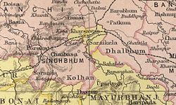 Dhalbhum as part of extended Singhbhum district in 1909 map of The Imperial Gazetteer of India | |||||||
| Area | |||||||
• 1872 | 3,111 km2 (1,201 sq mi) | ||||||
• 1891 | 2,970 km2 (1,150 sq mi) | ||||||
• 1941 | 3,004 km2 (1,160 sq mi) | ||||||
| Population | |||||||
• 1872 | 117,118 | ||||||
• 1891 | 194,469 | ||||||
• 1941 | 533,402 | ||||||
| • Type | Royal rules | ||||||
| History | |||||||
• Established | 15th century | ||||||
• Beginning of Revenue Settlement negotiation with British | 1767 | ||||||
• Revenue Settlement with British | 1777 | ||||||
• Merged with Manbhum | 1833 | ||||||
• Merged with Singhbhum | 1846 | ||||||
| 1879 | |||||||
| |||||||
| Today part of | East Singhbhum district of Jharkhand | ||||||
Dhalbhum was an estate in early modern period and British India, spread across the East Singhbhum district in present-day Jharkhand, [1] western part of Bankura, [2] and Midnapore district of West Bengal.
