
Cranbrook is a small town in the Shire of Cranbrook in the Great Southern region of Western Australia between Katanning, Kojonup and Mount Barker, situated 320 km south of Perth. It is billed as "The Gateway to the Stirlings", referring to the nearby Stirling Range National Park. At the 2006 census, Cranbrook had a population of 280.

Narrikup is a small town and locality in the Shire of Plantagenet, Great Southern region of Western Australia. Narrikup is located between Albany and Mount Barker. At the 2006 census, Narrikup had a population of 515.

The Shire of Kent is a local government area in the Great Southern region of Western Australia, about 320 kilometres (200 mi) southeast of Perth, the state capital. The Shire covers an area of 5,634 square kilometres (2,175 sq mi) and its seat of government is the town of Nyabing. The area produces grains such as wheat, barley and legumes.
Frankland River is a small town and locality in the Shire of Cranbrook, Great Southern region of Western Australia. The town is situated approximately 332.7 km (206.7 mi) from the state's capital, Perth, approximately 120 km (75 mi) north west of Albany, 83 km (52 mi) southwest of Kojonup, 19 km (12 mi) north of Rocky Gully and 90 km (56 mi) east of Manjimup. Frankland derives its name from its location 6 km east of the Frankland River. At the 2006 census, Frankland had a population of 380.

The Town of Bassendean is a local government area in the northeastern suburbs of the Western Australian capital city of Perth, 6 kilometres (4 mi) west of the industrial centre of Midland and about 12 kilometres (7 mi) northeast of Perth's central business district. The Town covers an area of 10.4 square kilometres (4.0 sq mi), maintains 97 km of roads and had a population of approximately 15,000 as at the 2016 Census. The Town of Bassendean is a member of the Eastern Metropolitan Regional Council.

The Shire of Kojonup is a local government area in the Great Southern region of Western Australia, about 250 kilometres (155 mi) southeast of the state capital, Perth, along Albany Highway. The Shire covers an area of 2,932 square kilometres (1,132 sq mi) and its seat of government is the town of Kojonup.

The Shire of Cranbrook is a local government area in the Great Southern region of Western Australia, about 92 kilometres (57 mi) north of Albany and about 320 kilometres (200 mi) south-southeast of the state capital, Perth. The Shire covers an area of 3,277 square kilometres (1,265 sq mi), and its seat of government is the town of Cranbrook.

The Shire of Woodanilling is a local government area in the Great Southern region of Western Australia, about 30 kilometres (19 mi) south of Wagin and about 260 kilometres (162 mi) south-southeast of the state capital, Perth. The Shire covers an area of 1,129 square kilometres (436 sq mi), and its seat of government is the town of Woodanilling.
Nyabing is a small town and locality in the Great Southern region of Western Australia. The name is of Aboriginal origin and is thought to derive from the Aboriginal word "ne-yameng", which is the name of an everlasting flower Rhodanthe manglesii. It is one of two localities in the Shire of Kent, the other being Pingrup, covering the east of the shire.
Boxwood Hill is a town and locality in the Shire of Jerramungup, Great Southern region of Western Australia. Boxwood Hill is situated at the intersection of the South Coast Highway and the Borden-Bremer Bay Road.
Nornalup is a small town and locality in the Shire of Denmark in the Great Southern region of Western Australia. The town is located along the South Coast Highway and on the banks of the Frankland River. The name derives from the local indigenous language: "place of the black snake" - Norne - meaning "black snake" - and up meaning "place of". The area attracts considerable numbers of tiger snakes due to its proximity to the river and wetlands, though fewer now than in the past. Anecdotal evidence from early settlers mentions uncomfortably large numbers of these highly venomous and aggressive reptiles, particularly during spring and early summer.
Pingrup is a small town and locality in the Great Southern region of Western Australia. It is one of two localities in the Shire of Kent, the other being Nyabing, covering the west of the shire.
Rocky Gully is a small town and locality in the Shire of Plantagenet, Great Southern region of Western Australia.
Jingalup is a town and locality in the Shire of Kojonup, Great Southern region of Western Australia. Jingalup is located between the towns of Kojonup and Cranbrook, on Murrin Brook, which is a tributary of the Tone River.
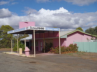
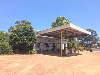
Tunney is a gazetted townsite located along the Albany Highway between Kojonup and Cranbrook, in the Shire of Cranbrook and Shire of Broomehill-Tambellup in the Great Southern region of Western Australia. The Albany Highway forms the shire boundary in this area and the area of the townsite of Tunney spans either side of the highway. Because of its location across two shires, Tunney has two postcodes, 6320 for the eastern part, located in Broomehill-Tambellup, and 6321 for the western part, located in Cranbrook.
Needilup is a town and locality in the Shire of Jerramungup, Great Southern region of Western Australia. Needilup is situated between Ongerup and Jerramungup along the Gnowangerup-Jerramungup Road.
Muradup is a small town and locality in the Shire of Kojonup, Great Southern region of Western Australia. Muradup is located between Kojonup and Boyup Brook, and is situated along the Balgarup River.
Dingup is a rural locality of the Shire of Manjimup in the South West region of Western Australia. The Muir Highway forms the western and southern border of the locality.
Lumeah is a locality in the Shire of Kojonup, Great Southern region of Western Australia.

Kulikup is a rural locality and small town of the Shire of Boyup Brook in the South West region of Western Australia.

