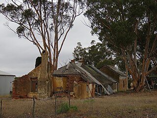
Cranbrook is a small town in the Shire of Cranbrook in the Great Southern region of Western Australia between Katanning, Kojonup and Mount Barker, situated 320 km south of Perth. It is billed as "The Gateway to the Stirlings", referring to the nearby Stirling Range National Park. At the 2006 census, Cranbrook had a population of 280.

The Shire of Kent is a local government area in the Great Southern region of Western Australia, about 320 kilometres (200 mi) southeast of Perth, the state capital. The Shire covers an area of 5,634 square kilometres (2,175 sq mi) and its seat of government is the town of Nyabing. The area produces grains such as wheat, barley and legumes.
Nyabing is a small town and locality in the Great Southern region of Western Australia. The name is of Aboriginal origin and is thought to derive from the Aboriginal word "ne-yameng", which is the name of an everlasting flower Rhodanthe manglesii. It is one of two localities in the Shire of Kent, the other being Pingrup, covering the east of the shire.
Pingrup is a small town and locality in the Great Southern region of Western Australia. It is one of two localities in the Shire of Kent, the other being Nyabing, covering the west of the shire.
Jingalup is a town and locality in the Shire of Kojonup, Great Southern region of Western Australia. Jingalup is located between the towns of Kojonup and Cranbrook, on Murrin Brook, which is a tributary of the Tone River. The locality is home to the Jingalup and South Jingalup Nature Reserves.
Muradup is a small town and locality in the Shire of Kojonup, Great Southern region of Western Australia. Muradup is located between Kojonup and Boyup Brook, and is situated along the Balgarup River. The Narlingup Nature Reserve is located in the west of Muradup.
Broomehill West is a rural locality of the Shire of Broomehill–Tambellup of the Great Southern region of Western Australia, adjacent to the town of Broomehill. The Great Southern Highway and the Great Southern Railway, for the most part, form the eastern border of the locality. A small part of the gazetted townsite of Peringillup and a major part of the Peringillup Nature Reserve are located within Broomehill West.

Broomehill East is a rural locality of the Shire of Broomehill–Tambellup of the Great Southern region of Western Australia, adjacent to the town of Broomehill. The Great Southern Highway and the Great Southern Railway, for the most part, form the western border of the locality. The majority of the gazetted townsite of Peringillup and parts of the Peringillup Nature Reserve are located within Broomehill East.
Borderdale is a rural locality of the Shire of Broomehill–Tambellup in the Great Southern region of Western Australia. The Albany Highway forms the south-western border of the locality. The eastern part of the gazetted townsite of Tunney is located in Borderdale, while the western part is located in Cranbrook, with the Albany Highway forming the border.
Wansbrough is a rural locality of the Shire of Broomehill–Tambellup in the Great Southern region of Western Australia. The Great Southern Highway and the Great Southern Railway run through the locality from north to south, while the Gordon River forms its north-eastern boundary. The Wansbrough and the Beejenup Nature Reserves are fully located in the locality, while the far northern end of the Balicup Lake Nature Reserve protrudes into the south of Wansbrough. The small eastern part of the gazetted townsite of Pootenup is located in Wansbrough, while the western part is located in Cranbrook, with the border running parallel to the railway line.
Lake Toolbrunup is a rural locality of the Shire of Broomehill–Tambellup in the Great Southern region of Western Australia. The Anderson Lake and the Three Swamps Nature Reserves are located within Lake Toolbrunup.
Carrolup is a rural locality of the Shire of Katanning in the Great Southern region of Western Australia. The small Carrolup Nature Reserve is located within Carrolup, on the Carrolup River, which flows through the locality from east to west.
South Glencoe is a rural locality of the Shire of Katanning in the Great Southern region of Western Australia. The Johns Well Nature Reserve is located within South Glencoe, as is a small part of the unnamed WA24282 Nature Reserve.

Ewlyamartup is a rural locality of the Shire of Katanning in the Great Southern region of Western Australia. Katanning Airport, Lake Ewlyamartup and the southern end of the Coblinine Nature Reserve are located in Ewlyamartup, while Ewlyamartup Creek runs through it.
Coblinine is a rural locality of the Shire of Katanning in the Great Southern region of Western Australia. The Coblinine Nature Reserve, situated along the Coblinine River, is located in Coblinine.
Coyrecup is a rural locality of the Shire of Katanning in the Great Southern region of Western Australia. The Coyrecup Nature Reserve, centred around Coyrecup Lake, is located within Coyrecup.
Pinwernying is a town and locality of the Shire of Katanning in the Great Southern region of Western Australia, adjacent to Katanning. The Great Southern Railway forms the western border of the locality.
West Fitzgerald is a rural locality of the Shire of Jerramungup in the Great Southern region of Western Australia. The South Coast Highway passes through the locality from west to east while its far south is made up of a part of the Fitzgerald River National Park.
Toompup is a rural locality of the Shire of Gnowangerup in the Great Southern region of Western Australia. Toompup borders the townsite of Borden and Chester Pass Road in the west and the townsite of Ongerup in the north-east. The Toompup Nature Reserve is located within Toompup.

Kebaringup is a town and locality of the Shire of Gnowangerup in the Great Southern region of Western Australia. Kebaringup borders the townsite of Borden to the south-east, while the Pallinup River forms much of its southern border. The Chirelillup Nature Reserve is located within Kebaringup.


