
John Septimus Roe was the first Surveyor-General of Western Australia. He was a renowned explorer, a member of Western Australia's legislative and executive councils for nearly 40 years, but also a participant in the Pinjarra massacre on 28 October 1834.

Cranbrook is a small town in the Shire of Cranbrook in the Great Southern region of Western Australia between Katanning, Kojonup and Mount Barker, situated 320 km south of Perth. It is billed as "The Gateway to the Stirlings", referring to the nearby Stirling Range National Park. At the 2006 census, Cranbrook had a population of 280.

The townsite of Tambellup is located in the Great Southern region of Western Australia, 317 km south-east of Perth on the Great Southern Highway where it crosses the Gordon River. It is 23 km south of Broomehill.

Ongerup is a town and locality in the Shire of Gnowangerup, Great Southern region of Western Australia. It is 410 kilometres (250 mi) south-east of Perth and 54 kilometres (34 mi) east of Gnowangerup. At the 2021 census Ongerup had a population of 114.

The Shire of Mount Marshall is a local government area in the Wheatbelt region of Western Australia, about 80 kilometres (50 mi) north-northwest of Merredin and about 300 kilometres (186 mi) northeast of the state capital, Perth. The Shire covers an area of 10,190 square kilometres (3,934 sq mi), and its seat of government is the town of Bencubbin.

Jerramungup is a town and locality in the Shire of Jerramungup, Great Southern region of Western Australia. Jerramungup is 454 kilometres (282 mi) southeast of Perth and 6 kilometres (4 mi) west of the Gairdner River.
Frankland River is a small town and locality in the Shire of Cranbrook, Great Southern region of Western Australia. The town is situated approximately 332.7 km (206.7 mi) from the state's capital, Perth, approximately 120 km (75 mi) north west of Albany, 83 km (52 mi) southwest of Kojonup, 19 km (12 mi) north of Rocky Gully and 90 km (56 mi) east of Manjimup. Frankland derives its name from its location 6 km east of the Frankland River. At the 2006 census, Frankland had a population of 380.

Kondinin is a town located in the eastern Wheatbelt region of Western Australia, 279 kilometres (173 mi) east of the state capital, Perth via the Brookton Highway and State Route 40 between Corrigin and Hyden. It is one of three towns in the Shire of Kondinin. At the 2006 census, Kondinin had a population of 311.

The Shire of Jerramungup is a local government area in the Great Southern region of Western Australia, about 180 kilometres (112 mi) northeast of Albany and about 440 kilometres (273 mi) southeast of the state capital, Perth. The Shire covers an area of 6,507 square kilometres (2,512 sq mi) with Bremer Bay its largest town. The seat of government is the town of Jerramungup.
Bremer Bay is a coastal town and locality in the Shire of Jerramungup, Great Southern region of Western Australia. It is situated on the south coast of the state, between Albany and Esperance, at the mouth of the Bremer River. Bremer Bay is 515 kilometres (320 mi) southeast of the state capital, Perth, and 180 kilometres (112 mi) east of Albany. It is on the lands of the Southern Noongar people of the Noongar nation. The claim for Native Title was made in September 2006.

Gairdner River is a river located in the Great Southern region of Western Australia.
Boxwood Hill is a town and locality in the Shire of Jerramungup, Great Southern region of Western Australia. Boxwood Hill is situated at the intersection of the South Coast Highway and the Borden-Bremer Bay Road.
Pingrup is a small town and locality in the Great Southern region of Western Australia. It is one of two localities in the Shire of Kent, the other being Nyabing, covering the west of the shire.
Lort River is a river in the Goldfields-Esperance region and the Eastern Mallee sub-region of Western Australia.
Gregory is a small town and fishing port located 7 km (4.3 mi) northwest of the mouth of the Hutt River, in the Mid West region of Western Australia. At the 2016 census, Gregory had a population of 64 in 83 dwellings. Most of the dwellings are holiday houses. The population of Gregory fluctuates depending on tourism; with the town at full capacity during school holidays and throughout the summer. During the census 50% of dwellings were unoccupied.
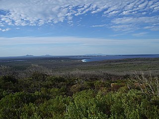
Gordon Inlet is an estuarine inlet, located in the Great Southern region of Western Australia. The inlet is at the south west corner of the Fitzgerald River National Park and approximately 15 kilometres (9 mi) north west of the town of Bremer Bay.
Jingalup is a town and locality in the Shire of Kojonup, Great Southern region of Western Australia. Jingalup is located between the towns of Kojonup and Cranbrook, on Murrin Brook, which is a tributary of the Tone River.
Needilup is a town and locality in the Shire of Jerramungup, Great Southern region of Western Australia. Needilup is situated between Ongerup and Jerramungup along the Gnowangerup-Jerramungup Road.
Moojebing is an abandoned townsite and locality on the Boyerine Creek in the Great Southern region of Western Australia, southeast of Woodanilling and north north west of Katanning. It is located within the Shire of Katanning.
The Gairdner River is located in the Kimberley region of Western Australia. The river is located in the west Kimberley, and is a 42 km long tributary of the Glenelg River.

