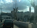
Algiers is the capital and largest city of Algeria as well as the capital of the Algiers Province. The city's population at the 2008 census was 2,988,145 and in 2020 was estimated to be around 4,500,000. Located in the north-central part of the country, it extends along the shores of the Bay of Algiers in the heart of the Maghreb region making it classified among the biggest cities in North Africa, the Arab world and the Mediterranean, due to it being a major center of culture, arts, gastronomy and trade.
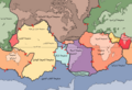
Kabylia or Kabylie is a mountainous coastal region in northern Algeria and the homeland of the Kabyle people. It is part of the Tell Atlas mountain range and is located at the edge of the Mediterranean Sea.
Tassili Airlines is an Algerian passenger airline, based in Algiers, owned by Sonatrach, the national state-owned oil company of Algeria.
859 Bouzaréah, provisional designation 1916 c, is a dark asteroid from the asteroid belt about 74 kilometers in diameter. It was discovered by French astronomer Frédéric Sy at the Algiers Observatory in Algeria, North Africa, on 2 October 1916.

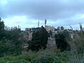
Bouzareah or Bouzaréah is a suburb of Algiers, Algeria. It had a population of 69,200 people in 1998 and an altitude of over 300 meters AMSL. The city's name is Arabic and means "of the grain" or "from the grain". The embassies of Niger, Oman, and Mauritania are located there.

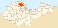
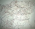
Algiers Province is a province (wilayah) in Algeria, named after its capital, Algiers, which is also the national capital. It is adopted from the old French department of Algiers and has a population of about 8 million. It is the most densely populated province of Algeria, and also the smallest by area.

Rouïba or Rouiba is a municipality of Algeria. It is located 22 kilometres (14 mi) in the eastern suburbs of Algiers in one of the most healthy localities of Algeria. It is also the district seat of Rouïba District in Algiers Province. Its inhabitants are called Rouibéens.
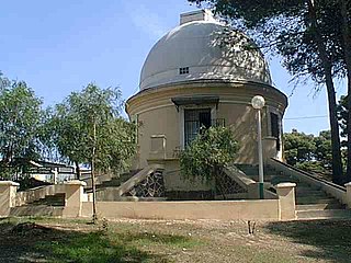
The Algiers Observatory was built in the late 19th century in the Algiers suburb of Bouzaréah, Algeria, North Africa. It participated in the Astrographic Catalogue project, taking the zone between -2 and +4 degrees to expose 1,260 plates between the years 1891 and 1911. At the tail end of that time, the director of the installation was François Gonnessiat.
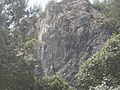
The Khachna Range is a mountain range of the Tell Atlas, part of the Atlas Mountain System. It is located in Kabylie, Algeria.

Algerian Broadcasting Company is an undertaking for the broadcasting of radio and television services in Algeria. TDA is a so-called public industrial and commercial company (EPIC), which means that it is an independent legal entity that manages a public service. TDA also offers internet, technical and satellite services. Algeria's Ministry of Communications is the supervisory authority for the TDA.

Bouzegza Mountain or Blue Mountain is a mountain peak in the Kheshna mountain range in the Atlas hill in Algeria, located in the municipality of Keddara in the district of Boudouaou in the Boumerdès governorate in Algeria.

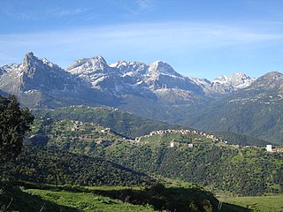
Rajaouna Mountain is a peak in the Djurdjura mountain range in the Tell Atlas in Algeria, located in the Tizi Ouzou, Tizi Ouzou District, Tizi Ouzou Province of the Kabylia region of Algeria.

Isaak Mountain is a peak in the Babor Mountains range of the Tell Atlas in Algeria, located in the municipality of Tizi N'Berber in the Aokas District.

Lake Akfadou, also known as Black Lake, is situated within the Djurdjura Mountains, within the boundaries of the Djurdjura National Park. It is located between the Algerian provinces of Tizi Ouzou and Béjaïa.
Bologhine Forest is a forest located in Bologhine, Algiers. It is managed by the Forest Conservation Authority of Algiers, which operates under the supervision of the Directorate General of Forests (DGF).
The forest known as Ain Taya Forest, Kadous Park, or Kadous Forest is situated in the Ain Taya area of Algiers Province. It is managed by the Directorate of Forests and Green Belt of Algiers, under the supervision of the General Directorate of Forests.
El-Mouradia Forest or Atlas Forest is situated in El-Mouradia, within Algiers Province. It is overseen by the Directorate of Forests and Green Belt of the Province of Algiers, under the guidance of the General Directorate of Forestry Algeria.

Reghaïa Valley is one of the rivers in the province of Algiers, stretching 17.13 kilometers to the east of the Algerian capital. Its mouth is located between the municipalities of Reghaïa and H'raoua. It is among the longest and most water-abundant rivers in the Algiers region. The river originates in the Tell Atlas and the Khachna Mountains, near the municipality of Kedara in the Boumerdes province, flowing through Algiers before draining into Lake Reghaïa near the Réghaïa forest, and eventually emptying into the Mediterranean Sea.
Boudouaou Valley is a river originating in the Khachna Mountains, flowing northward through the city of Boudouaou in Algeria. Along its journey, the valley traverses Boumerdès Province before emptying into the Mediterranean Sea.

Al-Hamiz Valley is a prominent river in Algiers Province, stretching 54 kilometers to the east of Algiers. Its mouth is located between the municipalities of Bordj El Kiffan and Bordj El Bahri. The river originates from the Tell Atlas and Titteri Mountains near the municipality of Deux Bassins in Médéa Province. It flows through the provinces of Bouira, Blida, Boumerdès, and Algiers before emptying into the Mediterranean Sea.