
The Town of Cambridge is a local government area in the inner western suburbs of the Western Australian capital city of Perth, about 5 kilometres (3 mi) west of Perth's central business district and extending to the Indian Ocean at City Beach. The Town covers an area of 22.0 square kilometres (8.5 sq mi) and had a population of almost 29,000 as of the 2021 Census. It was originally part of the City of Perth before the restructuring by the Western Australian State Government in 1994.

The Shire of Plantagenet is a local government area in the Great Southern region of Western Australia, managed from the town of Mount Barker, 360 kilometres (224 mi) south of Perth and 50 kilometres (31 mi) north of Albany. The shire covers an area of 4,792 square kilometres (1,850 sq mi) and includes the communities of Narrikup, Rocky Gully, Kendenup and Porongurup.

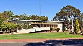
Narrikup is a small town and locality in the Shire of Plantagenet, Great Southern region of Western Australia. Narrikup is located between Albany and Mount Barker. At the 2006 census, Narrikup had a population of 515.

The Shire of Ngaanyatjarraku is a remote local government area in Western Australia near the Northern Territory/South Australian border. It is 1,542 km (958 mi) from Perth.

The Town of Bassendean is a local government area in the northeastern suburbs of the Western Australian capital city of Perth, 6 kilometres (4 mi) west of the industrial centre of Midland and about 12 kilometres (7 mi) northeast of Perth's central business district. The Town covers an area of 10.4 square kilometres (4.0 sq mi), maintains 97 km of roads and had a population of approximately 15,000 as at the 2016 Census. The Town of Bassendean is a member of the Eastern Metropolitan Regional Council.

The Shire of Murchison is a 49,500 km² local government area (LGA), within the Murchison sub-region, in the Mid West region of Western Australia. Encompassing most of the Murchison and East Murchison goldfields, the shire is named after the Murchison River. It is Australia's least-populated LGA and the only one without an official town. Five sparsely-populated rural localities, with a collective population of 101, comprise the entire shire. The shire offices, located 300 kilometres (186 mi) northeast of Geraldton, are the focal point of Murchison Settlement, a small part of the Murchison locality.

The Shire of Kojonup is a local government area in the Great Southern region of Western Australia, about 250 kilometres (155 mi) southeast of the state capital, Perth, along Albany Highway. The Shire covers an area of 2,932 square kilometres (1,132 sq mi) and its seat of government is the town of Kojonup.

The Shire of Shark Bay is a local government area of Western Australia in the Gascoyne region. It has an area of 25,423 km2 and a population of about 950. It is made up of two peninsulas and Shark Bay, located at the westernmost point of Australia. There is one town in the Shire of Shark Bay, Denham, which is the administrative centre for the Shire. There are also a number of small communities; they are Useless Loop, Monkey Mia, Nanga and Hamelin Pool. The Overlander and The Billabong are roadhouses.

The Shire of Jerramungup is a local government area in the Great Southern region of Western Australia, about 180 kilometres (112 mi) northeast of Albany and about 440 kilometres (273 mi) southeast of the state capital, Perth. The Shire covers an area of 6,507 square kilometres (2,512 sq mi) with Bremer Bay its largest town. The seat of government is the town of Jerramungup.

The Shire of Meekatharra is a local government area in the Mid West region of Western Australia, about halfway between the town of Port Hedland and the state capital, Perth, Western Australia. The Shire covers an area of 100,789 square kilometres (38,915 sq mi), and its seat of government is the town of Meekatharra.

The Shire of Mount Magnet is a local government area in the Mid West region of Western Australia, about 570 kilometres (354 mi) north-northeast of the state capital, Perth. The Shire covers an area of 13,692 square kilometres (5,287 sq mi), and its seat of government is the town of Mount Magnet. The Shire of Mount Magnet current president is James (Jim) McGorman.

The Shire of Woodanilling is a local government area in the Great Southern region of Western Australia, about 30 kilometres (19 mi) south of Wagin and about 260 kilometres (162 mi) south-southeast of the state capital, Perth. The Shire covers an area of 1,129 square kilometres (436 sq mi), and its seat of government is the town of Woodanilling.
The Shire of Broomehill-Tambellup is a local government area in the Great Southern region of Western Australia, 320 kilometres (200 mi) south-southeast of the state capital, Perth. The Shire covers an area of 2,609.1 square kilometres (1,007.4 sq mi), and its seat of government is the town of Tambellup. It came into existence in 2008 through the amalgamation of the former Shire of Broomehill and Shire of Tambellup.
Nyabing is a small town and locality in the Great Southern region of Western Australia. The name is of Aboriginal origin and is thought to derive from the Aboriginal word "ne-yameng", which is the name of an everlasting flower Rhodanthe manglesii. It is one of two localities in the Shire of Kent, the other being Pingrup, covering the east of the shire.
Boscabel is a town and locality in the Shire of Kojonup, Great Southern region of Western Australia, located north of Kojonup.
Pingrup is a small town and locality in the Great Southern region of Western Australia. It is one of two localities in the Shire of Kent, the other being Nyabing, covering the west of the shire.
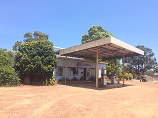
Rocky Gully is a small town and locality in the Shire of Plantagenet, Great Southern region of Western Australia.
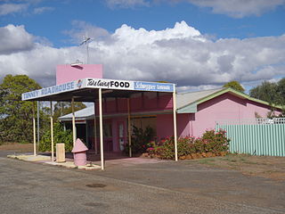
Tunney is a gazetted townsite located along the Albany Highway between Kojonup and Cranbrook, in the Shire of Cranbrook and Shire of Broomehill-Tambellup in the Great Southern region of Western Australia. The Albany Highway forms the shire boundary in this area and the area of the townsite of Tunney spans either side of the highway. Because of its location across two shires, Tunney has two postcodes, 6320 for the eastern part, located in Broomehill-Tambellup, and 6321 for the western part, located in Cranbrook.
Gairdner is a town and locality in the Shire of Jerramungup, Great Southern region of Western Australia. The town is located between Jerramungup and Boxwood Hill along the South Coast Highway, on Devil Creek, a tributary of the Bremer River.
Bow Bridge is a locality in the Great Southern of Western Australia. It is located between Denmark and Walpole on the South Coast Highway. It is also situated on the Bow River.

