
Ancaster is a village and civil parish in the South Kesteven district of Lincolnshire, England, on the site of a Roman town. The population of the civil parish was 1,317 at the 2001 census, increasing to 1,647 at the 2011 census. The civil parish includes the settlements of Sudbrook and West Willoughby.

Ropsley is a village in the South Kesteven district of Lincolnshire, England. The village is situated approximately 5 miles (8 km) east from Grantham, and falls within the civil parish of Ropsley and Humby.

Boothby Pagnell is a village and civil parish in the South Kesteven district of Lincolnshire, England. The population is now included in the civil parish of Bitchfield and Bassingthorpe.

Burton Coggles is a small village and civil parish in the South Kesteven district of Lincolnshire, England. The population is included in the civil parish of Bitchfield and Bassingthorpe. The village is situated 7 miles (11 km) south from Grantham, and between the B1176 road and the East Coast Main Line.

Braceby and Sapperton is a civil parish in the South Kesteven district of Lincolnshire, England. According to the 2001 census it had a population of 47. The parish consists of the two small villages of Braceby and Sapperton. Each village contains a small church dating from the 12th or 13th century.
Bassingthorpe is a small village in the civil parish of Bitchfield and Bassingthorpe, in the South Kesteven district of Lincolnshire, England. It is 5 miles (8 km) south from Grantham, and on a C class road between the B6403 to the west and the B1176 to the east. In 1921 the parish had a population of 78. On 1 April 1931 the parish was abolished and merged with Bitchfield to form "Bitchfield and Bassingthorpe".

Bitchfield is a village in the civil parish of Bitchfield and Bassingthorpe, in the South Kesteven district of Lincolnshire, England. It consists of two groups of buildings connected by Dark Lane, known as Bitchfield and Lower Bitchfield, collectively called Bitchfield. The village is situated approximately 6 miles (10 km) south-east from Grantham, and on the B1176 road, running east and parallel to the A1. In 1921 the parish had a population of 95. On 1 April 1931 the parish was abolished and merged with Bassingthorpe to form "Bitchfield and Bassingthorpe".

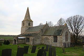
Castle Bytham is a village and civil parish of around 300 houses in South Kesteven, Lincolnshire, England. It is located 9 miles (14 km) north of Stamford and 9 miles (14 km) west of Bourne. The population was measured at 768 in 317 households at the 2011 census.

Muston is a village and former civil parish, now in the parish of Bottesford, in the Melton district of Leicestershire, England. It is 18.6 miles (29.9 km) east of Nottingham, five miles (8.0 km) west of Grantham on the A52 and 12.5 miles (20.1 km) north of Melton Mowbray. It lies on the border of Leicestershire and Lincolnshire, two miles east of Bottesford. The River Devon flows through the village. In 1931 the parish had a population of 218. On 1 April 1936 the parish was abolished and merged with Bottesford.

Sapperton is a village in the civil parish of Braceby and Sapperton, in the South Kesteven district of Lincolnshire, England. The nearest town is Grantham, 6 miles (9.7 km) to the west. Adjacent villages include Braceby, Pickworth and Ropsley. In 1921 the parish had a population of 46. On 1 April 1931 the parish was abolished and merged with Braceby to form "Braceby and Sapperton".

Haconby is a village and civil parish in the South Kesteven district of Lincolnshire, England. The population of the civil parish at the 2001 census was 448 increasing to 532 at the 2011 census. It is situated on the western edge of the Lincolnshire Fens, 3 miles (5 km) north from Bourne.
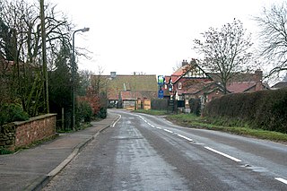
Old Somerby is a village and civil parish in the South Kesteven district of Lincolnshire, England, 3 miles (5 km) south-east of Grantham. It lies on the B1176 road, with the village centre about 1 mile (1.6 km) east of its junction with the A52 and B6403, and adjacent to the East Coast Main Line.
Careby Aunby and Holywell is a civil parish in the district of South Kesteven, south-west Lincolnshire, in England. It stretches from the county border with Rutland in the west to the River West Glen in the east. The B1176 road from Corby Glen passes through Careby and on past Aunby toward Stamford. The main London to Scotland railway line passes through the parish, the line upon which Mallard took the speed record for the LNER.

Keisby is a hamlet in the civil parish of Lenton, Keisby and Osgodby, in the South Kesteven district, in Lincolnshire, England. It is situated 6 miles (10 km) north-west from Bourne and 9 miles (14 km) south-east from Grantham. In 1921 the parish had a population of 72.

Pickworth is a village and civil parish in the South Kesteven district of Lincolnshire, England. The population of the civil parish including Braceby and Sapperton was 243 at the 2011 census. It is situated approximately 8 miles (13 km) both east from Grantham and south from Sleaford.

Little Ponton is a village in the civil parish of Little Ponton and Stroxton, in the South Kesteven district of Lincolnshire, England. It lies 2 miles (3 km) south of Grantham, about 60 metres (200 ft) above sea level.

Lenton is a village in the civil parish of Lenton, Keisby and Osgodby, in the district of South Kesteven, Lincolnshire, England. It is situated approximately 7 miles (11 km) south-east from Grantham. In 1921 the parish had a population of 117. On 1 April 1931 the parish was abolished to form "Lenton Keisby and Osgodby".
Winnibriggs and Threo was an anciently established wapentake in the Parts of Kesteven, the south-east division of the English county of Lincolnshire. Most of the administrative functions of the wapentake had been lost to other local units of government by 1832.
Ropsley and Humby is a civil parish in the South Kesteven district of Lincolnshire, England. According to the 2001 Census it had a population of 808, increasing to 816 at the 2011 census. The parish consists of the small villages of Ropsley and Great Humby and the larger Little Humby, and the Deserted Medieval Villages of Overton Green and Ogarth.

Little Ponton and Stroxton is a civil parish in the South Kesteven district of Lincolnshire, England. According to the 2001 Census it had a population of 135 across 62 homes, increasing to 235 at the 2011 census.

