Logan County is a county located in the U.S. state of Oklahoma. As of the 2020 census, the population was 49,555. Its county seat is Guthrie.

Grant County is a county located on the northern border of the U.S. state of Oklahoma. As of the 2020 census, the population was 4,169. Its county seat is Medford. Originally designated as part of the Cherokee Outlet, it was named County L in Oklahoma Territory at the time of its opening to non-Indian settlement. A county election renamed it for U.S. President Ulysses S. Grant.

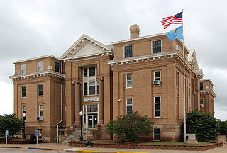
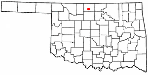
Garfield County is a county located in the U.S. state of Oklahoma. As of the 2020 census, the population was 62,846. Enid is the county seat and largest city within Garfield County. The county is named after President James A. Garfield.

Kiowa is a city in Barber County, Kansas, United States. As of the 2020 census, the population of the city was 902. It is located 1 mile north of the Kansas / Oklahoma state border.

Breckenridge is a city and county seat of Wilkin County, Minnesota, United States. The population was 3,430 at the 2020 census.

Carrier is a town in Garfield County, Oklahoma, United States. The population was 85 at the 2010 census.

Covington is a town in Garfield County, Oklahoma, United States. The population was 477 at the 2020 census.

Douglas is a town in Garfield County, Oklahoma, United States. The population was 32 at the 2010 census.

Drummond is a town in Garfield County, Oklahoma, United States. The population was 455 at the 2010 census, up from 405 in 2000.

Fairmont is a town in Garfield County, Oklahoma, United States. The population was 134 at the 2010 census, a decrease from 147 at the 2000 census.
Garber is a city in Garfield County, Oklahoma, United States. The population was 822 at the 2010 census. The city is named after Martin Garber, father of Milton C. Garber, former U.S. congressman, Enid mayor, newspaper editor, and judge. The land was previously part of the Cherokee Outlet, until the U.S. government declared it open to non-Indian settlement in 1893.

Lahoma is a town in Garfield County, Oklahoma, United States. The population was 611 at the 2010 census, a 5.9 percent gain over the figure of 577 in 2000. Its name was formed from the last three syllables of Oklahoma. Until the 1960s, Lahoma was a farm town. Later, it became primarily a bedroom community for people who commuted to work in Enid.

North Enid is a town in Garfield County, Oklahoma, United States. The population was 860 at the 2010 census. The town is served by the Chisholm school district. North Enid was the original railroad town site in the Enid–Pond Creek Railroad War.

Waukomis is a town in Garfield County, Oklahoma, United States. The population was 1,286 at the 2010 census, an increase of 2.0 percent from 1,261 in 2000.
Jefferson is a town in Grant County, Oklahoma, United States. The population was 12 at the 2010 census, a 67.6 percent decline from the figure of 37 in 2000.

Meno is a town in Major County, Oklahoma, United States. The population was 235 at the 2010 census, a 20.5 percent increase from the figure of 195 in 2000.

Billings is a town in northwest Noble County, Oklahoma, United States. The population was 509 at the 2010 census, an increase from the figure of 436 in 2000. It was the childhood home of Oklahoma governor Henry Bellmon.

Hollister is a town in Tillman County, Oklahoma, United States. The population was 35 as of the 2020 United States census. The town is located about 12 driving miles east-southeast of the county seat of Frederick, and is located along Oklahoma State Highway 54.

Bessie is a town in Washita County, Oklahoma, United States. The population was 181 at the 2010 census, a 4.7 percent decline from 190 in 2000.

Avard is a settlement in Woods County, Oklahoma, United States. It is southwest of Alva, and northeast of Waynoka. The population was 26 at the 2000 census. After initial growth, Avard began declining in the 1930s. Avard had a post office from June 1, 1895, until November 22, 1963. As of the 2010 census, Avard was listed as disincorporated, although it still appears as a Census-Designated Place.

