Briarcliff, Arkansas | |
---|---|
Coordinates: 36°16′19″N92°16′56″W / 36.27194°N 92.28222°W [1] | |
Country | United States |
State | Arkansas |
County | Baxter |
Area | |
• Total | 2.25 sq mi (5.83 km2) |
• Land | 2.25 sq mi (5.83 km2) |
• Water | 0.00 sq mi (0.00 km2) |
Elevation | 709 ft (216 m) |
Population (2020) | |
• Total | 236 |
• Density | 104.84/sq mi (40.47/km2) |
Time zone | UTC-6 (Central (CST)) |
• Summer (DST) | UTC-5 (CDT) |
FIPS code | 05-08665 |
GNIS feature ID | 2403922 [1] |
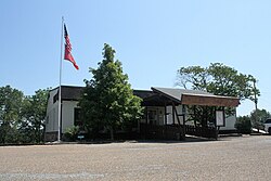
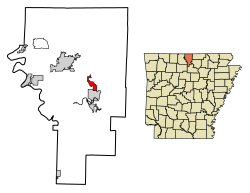
Briarcliff is a second-class city in Baxter County, Arkansas, United States. [3] The population was 236 at the 2010 census.
The community began as a small retirement community near Lake Norfork following completion of the Norfork Dam. Initially an unincorporated area, residents voted to incorporate as a town in 1997. In 2000, town residents approved upgrading Briarcliff's status to a second-class city in order to establish a municipal government. [3]
According to the United States Census Bureau, the town has a total area of 4.7 km2 (1.8 sq mi), all land.
Briarcliff is in the Norfork School District with students graduating from Norfork High School. [4]
Census | Pop. | Note | %± |
---|---|---|---|
2000 | 240 | — | |
2010 | 236 | −1.7% | |
2020 | 236 | 0.0% | |
U.S. Decennial Census [5] |
As of the census [6] of 2000, there were 240 people, 98 households, and 68 families residing in the town. The population density was50.9 people /km2 (132 people/sq mi). There were 117 housing units at an average density of 24.8 units /km2 (64 units/sq mi). The racial makeup of the town was 97.92% White, 0.83% Native American, and 1.25% from two or more races.
There were 98 households, out of which 32.7% had children under the age of 18 living with them, 56.1% were married couples living together, 10.2% had a female householder with no husband present, and 30.6% were non-families. 29.6% of all households were made up of individuals, and 14.3% had someone living alone who was 65 years of age or older. The average household size was 2.45 and the average family size was 2.94.
In the town the population was spread out, with 29.2% under the age of 18, 7.5% from 18 to 24, 22.1% from 25 to 44, 24.6% from 45 to 64, and 16.7% who were 65 years of age or older. The median age was 38 years. For every 100 females, there were 101.7 males. For every 100 females age 18 and over, there were 104.8 males.
The median income for a household in the town was $26,875, and the median income for a family was $32,188. Males had a median income of $26,000 versus $16,250 for females. The per capita income for the town was $16,420. About 9.0% of families and 13.7% of the population were below the poverty line, including 21.7% of those under the age of eighteen and 5.1% of those 65 or over.
Izard County is a county located in the U.S. state of Arkansas. As of the 2020 census, the population was 13,577. The county seat is Melbourne. Izard County is Arkansas's 13th county, formed on October 27, 1825, and named for War of 1812 General and Arkansas Territorial Governor George Izard. It is an alcohol prohibition or dry county.
Fulton County is a county located in the U.S. state of Arkansas. As of the 2020 census, the population was 12,075. The county seat is Salem. Fulton County was formed on December 21, 1842, and named for William Fulton, the last governor of the Arkansas Territory. It is an alcohol prohibition or dry county.
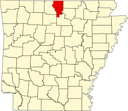
Baxter County is a county in the Ozark Mountains of Arkansas. Created as Arkansas's 66th county on March 24, 1873, the county has eight incorporated municipalities, including Mountain Home, its largest city and county seat. The county is named for Elisha Baxter, the tenth governor of Arkansas. It is coterminal with the Mountain Home Micropolitan Statistical Area.
Big Flat is a town in Baxter and Searcy counties in the U.S. state of Arkansas. The population was 88 at the 2020 census.
Gassville is a city in Baxter County, Arkansas, United States. According to the 2020 census, the city population was 2,171.
Lakeview is a city in Baxter County, Arkansas, United States. The population was 741 at the 2010 census.
Mountain Home is a city in and the county seat of Baxter County, Arkansas, United States, in the southern Ozark Mountains near the northern state border with Missouri. As of the 2010 census, the city had a population of 12,448. A total of 41,307 persons lived within the city and micropolitan area combined, which encompasses the majority of Baxter County.
Norfork is a city in Baxter County, Arkansas, United States. The population was 550 at the 2010 census.
Salesville is a city in Baxter County, Arkansas, United States. The population was 450 in 2010.
South Lead Hill is a town in Boone County, Arkansas, United States. The population was 102 at the 2010 census. It is part of the Harrison Micropolitan Statistical Area.
Campbell Station is a city in Jackson County, Arkansas, United States. The population was 255 at the 2010 census.
Allport is a town in Lonoke County, Arkansas, United States. Although a black enclave in the largely-white Lonoke County since the 1870s, the town did not incorporate until 1967 in order to receive funding for municipal services. Located within Central Arkansas along Highway 165, the community's economy is strongly tied to agriculture. The population was 115 at the 2010 Census.
Fourche is a town in Perry County, Arkansas, United States. The population was 59 at the 2000 census. It is part of the Little Rock–North Little Rock–Conway Metropolitan Statistical Area.
Hatfield is a town in western Polk County, Arkansas, United States. The population was 413 at the 2010 census.
Hector is a town in Pope County, Arkansas, United States. The population was 450 at the 2010 census. It is part of the Russellville Micropolitan Statistical Area.
Bonanza is a city in Sebastian County, Arkansas, United States. It is part of the Fort Smith, Arkansas-Oklahoma Metropolitan Statistical Area. At the 2010 Census, the population of Bonanza was 575. According to the 2018 US Census Bureau estimates, the population of Bonanza was 564. Bonanza began as a coal mining town of the Central Coal and Coke company.
Central City is a city in Sebastian County, Arkansas, United States. It is part of the Fort Smith, Arkansas-Oklahoma Metropolitan Statistical Area. At the 2010 Census, the population of Central City was 502. According to the 2018 US Census Bureau estimates, Central City had a population of 497.
Felsenthal is a town in Union County, Arkansas, United States. The population was 152 at the 2000 census and 150 at the 2010 census. It lays adjacent to the Ouachita River in the southeastern corner of Union County.
Garner is a town in White County, Arkansas, United States. The population was 284 at the 2000 census.
Griffithville is a town in White County, Arkansas, United States. The population was 262 at the 2000 census.