Broadland, South Dakota

Last updated

Broadland, South Dakota
Beadle County South Dakota Incorporated and Unincorporated areas Broadland Highlighted.svg
Location in Beadle County and the state of South Dakota
Coordinates: 44°29′38″N98°20′47″W / 44.49389°N 98.34639°W / 44.49389; -98.34639
Country United States
State South Dakota
County Beadle
Incorporated1911 [1]
Area
[2]
  Total1.01 sq mi (2.61 km2)
  Land1.01 sq mi (2.61 km2)
  Water0.00 sq mi (0.00 km2)
Elevation
[3]
1,303 ft (397 m)
Population
 (2020) [4]
  Total27
  Density26.81/sq mi (10.35/km2)
Time zone UTC-6 (Central (CST))
  Summer (DST) UTC-5 (CDT)
ZIP code
57350
Area code 605
FIPS code 46-07420 [5]
GNIS feature ID2396603 [3]

Broadland is a town in Beadle County, South Dakota, United States. The population was 27 at the 2020 census. [6]

Contents

History

Broadland was laid out in 1881. [7] It was named from the broad valley in which the town site is located. [7]

Geography

According to the United States Census Bureau, the town has a total area of 1.01 square miles (2.62 km2), all land. [8]

Demographics

Historical population
CensusPop.Note
1920 129
1930 102−20.9%
1940 73−28.4%
1950 741.4%
1960 33−55.4%
1970 4536.4%
1980 498.9%
1990 40−18.4%
2000 38−5.0%
2010 31−18.4%
2020 27−12.9%
U.S. Decennial Census [9] [4]

2010 census

As of the census [10] of 2010, there were 31 people, 13 households, and 10 families residing in the town. The population density was 30.7 inhabitants per square mile (11.9/km2). There were 18 housing units at an average density of 17.8 per square mile (6.9/km2). The racial makeup of the town was 100.0% White.

There were 13 households, of which 23.1% had children under the age of 18 living with them, 76.9% were married couples living together, and 23.1% were non-families. 23.1% of all households were made up of individuals, and 7.7% had someone living alone who was 65 years of age or older. The average household size was 2.38 and the average family size was 2.80.

The median age in the town was 50.8 years. 22.6% of residents were under the age of 18; 3.2% were between the ages of 18 and 24; 16.2% were from 25 to 44; 48.4% were from 45 to 64; and 9.7% were 65 years of age or older. The gender makeup of the town was 51.6% male and 48.4% female.

2000 census

As of the census [5] of 2000, there were 38 people, 14 households, and 11 families residing in the town. The population density was 38.0 inhabitants per square mile (14.7/km2). There were 15 housing units at an average density of 15.0 per square mile (5.8/km2). The racial makeup of the town was 100.00% White.

There were 14 households, out of which 42.9% had children under the age of 18 living with them, 71.4% were married couples living together, 7.1% had a female householder with no husband present, and 21.4% were non-families. 21.4% of all households were made up of individuals, and none had someone living alone who was 65 years of age or older. The average household size was 2.71 and the average family size was 3.18.

In the town, the population was spread out, with 28.9% under the age of 18, 5.3% from 18 to 24, 31.6% from 25 to 44, 23.7% from 45 to 64, and 10.5% who were 65 years of age or older. The median age was 40 years. For every 100 females, there were 100.0 males. For every 100 females age 18 and over, there were 107.7 males.

The median income for a household in the town was $34,583, and the median income for a family was $71,250. Males had a median income of $34,583 versus $100,000 for females. The per capita income for the town was $20,059. None of the population and none of the families were below the poverty line.

See also

Related Research Articles

<span class="mw-page-title-main">McCordsville, Indiana</span> Town in Indiana, United States

McCordsville is a town in Vernon Township, Hancock County, Indiana, United States. The town is a fast-growing suburb of Indianapolis with an estimated population of 8,592 in 2020.

<span class="mw-page-title-main">St. Olaf, Iowa</span> City in Iowa, United States

St. Olaf is a large village in Clayton County, Iowa, United States. The population was 106 at the time of the 2020 census, down from 136 in 2000. Swiss Valley has a large cheese packaging plant in St. Olaf. There is also a large feed granary, a post office, and a tavern.

Lynd Township is a township in Lyon County, Minnesota, United States. The population was 471 at the 2000 census.

<span class="mw-page-title-main">Outlook, Montana</span> Town in Montana, United States

Outlook is a small rural village in Sheridan County, Montana, United States. The population was 84 at the 2020 census. The village includes a post office which services Outlook and the hamlet of Raymond, as well as the surrounding countryside.

<span class="mw-page-title-main">Fullerton, North Dakota</span> City in North Dakota, United States

Fullerton is a city in Dickey County, North Dakota, United States. The population was 62 at the 2020 census. The town is home to the Carroll House Hotel, which is listed on the National Register of Historic Places.

<span class="mw-page-title-main">Killdeer, North Dakota</span> City in North Dakota, United States

Killdeer is a city in Dunn County, North Dakota, United States. The population was 939 at the 2020 census.

<span class="mw-page-title-main">Havana, North Dakota</span> City in North Dakota, United States

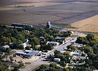
Havana is a city in Sargent County, North Dakota, United States. The population was 67 at the 2020 census. Havana was founded in 1887.

<span class="mw-page-title-main">Oliver Township, Mifflin County, Pennsylvania</span> Township in Pennsylvania, United States

Oliver Township is a township in Mifflin County, Pennsylvania, United States. The population was 2,060 at the time of the 2020 census.

<span class="mw-page-title-main">Stratford, South Dakota</span> Town in South Dakota, United States

Stratford is a town in southern Brown County, South Dakota, United States. The population was 57 at the 2020 census.

<span class="mw-page-title-main">Westport, South Dakota</span> Town in South Dakota, United States

Westport is a town in western Brown County, South Dakota, United States. The population was 88 at the 2020 census.

<span class="mw-page-title-main">Onaka, South Dakota</span> Town in South Dakota, United States

Onaka is a town in Faulk County, South Dakota, United States. The population was 13 at the 2020 census.

<span class="mw-page-title-main">Orient, South Dakota</span> Town in South Dakota, United States

Orient is a town in Faulk County, South Dakota, United States. The population was 51 at the 2020 census.

<span class="mw-page-title-main">St. Lawrence, South Dakota</span> Town in South Dakota, United States

St. Lawrence or Saint Lawrence is a town in central Hand County, South Dakota, United States. The population was 164 at the 2020 census.

<span class="mw-page-title-main">Hudson, South Dakota</span> Town in South Dakota, United States

Hudson is a town in Lincoln County, South Dakota, United States. The population was 311 at the 2020 census. It is the easternmost community in South Dakota.

<span class="mw-page-title-main">Sherman, South Dakota</span> Town in South Dakota, United States

Sherman is a town in Minnehaha County, South Dakota, United States. The population was 81 at the 2020 census.

<span class="mw-page-title-main">Phenix, Virginia</span> Town in Virginia, United States

Phenix is a town in Charlotte County, Virginia, United States. The population was 226 at the 2010 census.

<span class="mw-page-title-main">Ivor, Virginia</span> Town in Virginia, United States

Ivor is an incorporated town in Southampton County, Virginia, United States. It is twenty-three miles northwest of Suffolk. The population was 320 at the 2000 census.

<span class="mw-page-title-main">West Milford, West Virginia</span> Town in West Virginia, United States

West Milford is a town in Harrison County, West Virginia, United States. The population was 452 at the 2020 census.

<span class="mw-page-title-main">Kinnickinnic, Wisconsin</span> Town in Wisconsin, United States

Kinnickinnic is a town in St. Croix County, Wisconsin, United States. The population was 1,400 at the 2000 census.

<span class="mw-page-title-main">Wilton, North Dakota</span> City in North Dakota, United States

Wilton is a city in Burleigh and McLean counties in North Dakota, United States. It is part of the "Bismarck, ND Metropolitan Statistical Area" or "Bismarck-Mandan". The population was 718 at the 2020 census. Founded in 1899, Wilton was named by General W. D. Washburn after the town of Wilton in his native state of Maine.

References

  1. "SD Towns" (PDF). South Dakota State Historical Society. Archived from the original (PDF) on February 10, 2010. Retrieved February 11, 2010.
  2. "ArcGIS REST Services Directory". United States Census Bureau. Retrieved October 15, 2022.
  3. 1 2 U.S. Geological Survey Geographic Names Information System: Broadland, South Dakota
  4. 1 2 "Census Population API". United States Census Bureau. Retrieved October 15, 2022.
  5. 1 2 "U.S. Census website". United States Census Bureau . Retrieved January 31, 2008.
  6. "U.S. Census Bureau: Broadland town, South Dakota". www.census.gov. United States Census Bureau. Retrieved February 5, 2022.
  7. 1 2 Chicago and North Western Railway Company (1908). A History of the Origin of the Place Names Connected with the Chicago & North Western and Chicago, St. Paul, Minneapolis & Omaha Railways. p. 47.
  8. "US Gazetteer files 2010". United States Census Bureau. Archived from the original on January 25, 2012. Retrieved June 21, 2012.
  9. "Census of Population and Housing". Census.gov. Retrieved June 4, 2015.
  10. "U.S. Census website". United States Census Bureau . Retrieved June 21, 2012.

Commons-logo.svg Media related to Broadland, South Dakota at Wikimedia Commons