Brooker, Florida

Last updated

Brooker, Florida
Town of Brooker
Brooker, Florida.jpg
Brooker Water Tower
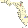
Bradford County Florida Incorporated and Unincorporated areas Brooker Highlighted.svg
Location in Bradford County and the state of Florida
Coordinates: 29°53′20″N82°19′53″W / 29.88889°N 82.33139°W / 29.88889; -82.33139
Country Flag of the United States.svg  United States
State Flag of Florida.svg  Florida
County   Bradford
Settled (Ward City) 1838 [1]
Settled (Vandy) April 17, 1893-August 23, 1894 [2] [3] [4]
Unincorporated (Brooker) August 24, 1894 [2] [3] [4]
Incorporated
(Town of Brooker)
1952 [5]
Government
  Type Mayor-Council
   Mayor Cecil "C.E. Gene" Melvin
   Vice Mayor Steve Acree
   Councilors Linda Bennett,
Chris Caldwell, and
Joe Tolleson
   Town Clerk Charlene Thomas
   Town Attorney John Maines IV
Area
[6]
  Total0.53 sq mi (1.37 km2)
  Land0.53 sq mi (1.37 km2)
  Water0.00 sq mi (0.00 km2)
Elevation
128 ft (39 m)
Population
 (2020)
  Total322
  Density611.01/sq mi (235.81/km2)
Time zone UTC-5 (Eastern (EST))
  Summer (DST) UTC-4 (EDT)
ZIP code
32622
Area code 352
FIPS code 12-08725 [7]
GNIS feature ID0279434 [8]
Website townofbrooker.com

Brooker is a town in Bradford County, Florida, United States. It is part of the North Florida region. The population was 322 at the 2020 census.
Contents

History

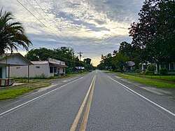
A street view of Brooker homes and stores Brooker, Florida 2.jpg
A street view of Brooker homes and stores

In 1838, the community was initially called "Ward City", which was named after an early settler, E. P. Ward. [1] In 1892, Thomas R. Collins petitioned for a US Post Office, and became postmaster in 1894. Between April 17, 1893, and August 23, 1894, the post office was briefly renamed "Vandy", before ultimately being renamed yet again as "Brooker" on August 24, 1894. [2] [3] [4]

Collins renamed the post office after the old Brooker Bridge located across the Santa Fe River, and that bridge was named after Ed Brooker, an early farmer from the community. The postmaster decided to change the name of the area because a majority of the citizens preferred the name "Brooker" over the original community's name, "Ward City". [1] [2] [3] Although being around since 1838, the "Town of Brooker" wasn't officially incorporated as a municipality until 1952. [5]

Geography

The exact coordinates for the Town of Brooker is located in western Bradford County at 29°53′20″N82°19′53″W / 29.88889°N 82.33139°W / 29.88889; -82.33139 (29.888922, –82.331397). [9]

It is 17 miles (27 km) west of Starke, the county seat. The town has an offshoot of the Santa Fe River running through its town limits as well as Florida State Road 235.

According to the United States Census Bureau, the town has a total area of 0.54 square miles (1.4 km2), all land.

Climate

The climate in this area is characterized by hot, humid summers and generally mild winters. According to the Köppen climate classification, the Town of Brooker has a humid subtropical climate zone (Cfa).

Demographics

Historical population
CensusPop.Note
1950 277
1960 2925.4%
1970 34016.4%
1980 42926.2%
1990 312−27.3%
2000 35212.8%
2010 338−4.0%
2020 322−4.7%
U.S. Decennial Census [10]

2010 and 2020 census

Brooker racial composition
(Hispanics excluded from racial categories)
(NH = Non-Hispanic)
RacePop 2010 [11] Pop 2020 [12] % 2010% 2020
White (NH)31028191.72%87.27%
Black or African American (NH)18185.33%5.59%
Native American or Alaska Native (NH)000.00%0.00%
Asian (NH)110.30%0.31%
Pacific Islander or Native Hawaiian (NH)000.00%0.00%
Some other race (NH)100.30%0.00%
Two or more races/Multiracial (NH)0100.00%3.11%
Hispanic or Latino (any race)8122.37%3.73%
Total338322

As of the 2020 United States census, there were 322 people, 113 households, and 82 families residing in the town. [13]

As of the 2010 United States census, there were 338 people, 142 households, and 104 families residing in the town. [14]

2000 census

As of the census [7] of 2000, there were 352 people, 123 households, and 93 families residing in the town. The population density was 670.7 inhabitants per square mile (259.0/km2). There were 136 housing units at an average density of 259.1 per square mile (100.0/km2). The racial makeup of the town was 97.44% White, 0.57% African American, 1.14% from other races, and 0.85% from two or more races. Hispanic or Latino of any race were 3.12% of the population.

In 2000, there were 123 households, out of which 36.6% had children under the age of 18 living with them, 60.2% were married couples living together, 13.8% had a female householder with no husband present, and 23.6% were non-families. 22.8% of all households were made up of individuals, and 8.9% had someone living alone who was 65 years of age or older. The average household size was 2.69 and the average family size was 3.16.

In 2000, in the town, the population was spread out, with 26.1% under the age of 18, 8.8% from 18 to 24, 24.1% from 25 to 44, 25.0% from 45 to 64, and 15.9% who were 65 years of age or older. The median age was 38 years. For every 100 females, there were 86.2 males. For every 100 females age 18 and over, there were 88.4 males.

In 2000, the median income for a household in the town was $40,000, and the median income for a family was $40,938. Males had a median income of $29,000 versus $22,000 for females. The per capita income for the town was $15,091. About 8.8% of families and 14.0% of the population were below the poverty line, including 2.6% of those under age 18 and 22.0% of those age 65 or over.

Related Research Articles

<span class="mw-page-title-main">Glen St. Mary, Florida</span> Town in Florida, United States

Glen St. Mary is a town in Baker County, Florida, United States. The Town of Glen St. Mary is part of the Jacksonville, Florida Metropolitan Statistical Area in North Florida. The population was 463 at the 2020 census, up from 437 at the 2010 census.

<span class="mw-page-title-main">Lawtey, Florida</span> City in Florida, United States

Lawtey is a city in Bradford County, Florida, United States. The population was 636 at the 2020 US Census, down from 730 at the 2010 US Census.

<span class="mw-page-title-main">Bell, Florida</span> Town in Florida, United States

Bell is a town in Gilchrist County, Florida, United States. The Town of Bell is situated in the northern part of the county, and located in North Florida. The population was 518 at the 2020 US Census, up from 456 at the 2010 US Census. It is part of the Gainesville, Florida Metropolitan Statistical Area.

<span class="mw-page-title-main">Fanning Springs, Florida</span> City in Florida, United States

Fanning Springs is a city in Gilchrist and Levy counties in the U.S. state of Florida. It is part of the Gainesville, Florida Metropolitan Statistical Area. The population was 1,182 at the 2020 census, up from 764 at the 2010 census.

<span class="mw-page-title-main">Noma, Florida</span> Town in the state of Florida, United States

Noma is a town in Holmes County, Florida, United States. The town is part of the Florida Panhandle in North Florida. The population was 208 at the 2020 census.

<span class="mw-page-title-main">Alford, Florida</span> Town in Florida, United States

Alford is a town in Jackson County, Florida, United States. The Town of Alford is located on the Florida Panhandle near Marianna, in North Florida. The population was 484 at the 2020 census.

<span class="mw-page-title-main">Bronson, Florida</span> Town in Florida, United States

Bronson is a town and the county seat of Levy County, Florida, United States. The population was 1,140 at the 2020 census, up from 1,113 at the 2010 census. It is part of the Gainesville, Florida Metropolitan Statistical Area.

<span class="mw-page-title-main">Inglis, Florida</span> Town in Florida, United States

Inglis is a town in Levy County, Florida, United States. It is on U.S. Highway 19 near the Cross Florida Greenway. As of the 2020 census, the town had a population of 1,476, up from 1,325 at the 2010 census. It is part of the Gainesville, Florida Metropolitan Statistical Area.

<span class="mw-page-title-main">Yankeetown, Florida</span> Town in the state of Florida, United States

Yankeetown is a town in Levy County, Florida, United States. Its located in North Florida along the Gulf of Mexico. The Town of Yankeetown is part of both the Big Bend Coast and the Nature Coast. In the 2020 census, the population was 588, up from 502 at the 2010 census. It is part of the Gainesville, Florida Metropolitan Statistical Area.

<span class="mw-page-title-main">Belleview, Florida</span> City in Florida, United States

Belleview is a city in Marion County, Florida, United States. The population was 5,413 at the 2020 census, up from 4,492 in 2010. It is part of the Ocala Metropolitan Statistical Area. The city's name comes from the French words belle and vue, meaning "beautiful view". "City with Small Town Charm" is the city's motto.

<span class="mw-page-title-main">Cinco Bayou, Florida</span> Town in Florida, United States

Cinco Bayou is a town in Okaloosa County, Florida, United States. The Town of Cinco Bayou is part of the Crestview–Fort Walton Beach–Destin, Florida Metropolitan Statistical Area. The population was 457 at the 2020 census, up from 383 at the 2010 census.

<span class="mw-page-title-main">Belleair Bluffs, Florida</span> City in Florida, United States

Belleair Bluffs is a city in Pinellas County, Florida, United States. It is part of the Tampa–St. Petersburg–Clearwater Metropolitan Statistical Area, more commonly known as the Tampa Bay Area. The population was 2,311 at the 2020 census.

<span class="mw-page-title-main">Indian Shores, Florida</span> Town in Florida, United States

Indian Shores is a town in Pinellas County, Florida, United States. It is part of the Tampa–St. Petersburg–Clearwater Metropolitan Statistical Area, more commonly known as the Tampa Bay Area. The population was 1,190 at the 2020 census.

<span class="mw-page-title-main">Kenneth City, Florida</span> Town in the state of Florida, United States

Kenneth City is a town in southern Pinellas County, Florida, between St. Petersburg and Pinellas Park, United States. It is part of the Tampa–St. Petersburg–Clearwater Metropolitan statistical area (MSA), much more commonly known as the Tampa Bay area. The population was 5,047 at the 2020 US census.

<span class="mw-page-title-main">North Redington Beach, Florida</span> Town in the state of Florida, United States

North Redington Beach is a town in Pinellas County, Florida, United States. It is part of the Tampa–St. Petersburg–Clearwater Metropolitan Statistical Area, more commonly known as the Tampa Bay Area. The population was 1,495 at the 2020 census.

<span class="mw-page-title-main">Redington Beach, Florida</span> Town in the state of Florida, United States

Redington Beach is a town in Pinellas County, Florida, United States. It is part of the Tampa–St. Petersburg–Clearwater Metropolitan Statistical Area, more commonly called the Tampa Bay Area. The population was 1,376 at the 2020 census.

<span class="mw-page-title-main">Redington Shores, Florida</span> Town in the state of Florida, United States

Redington Shores is a town in Pinellas County, Florida, United States. The county is part of the Tampa–St. Petersburg–Clearwater Metropolitan Statistical Area, more commonly known as the Tampa Bay Area. The population was 2,176 at the 2020 census.

<span class="mw-page-title-main">Branford, Florida</span> Town in Florida, United States

Branford is a town in Suwannee County, Florida, United States. The Town of Branford was officially incorporated as a municipality in 1961, although it has been settled since 1886. The population was 711 at the 2020 census.

<span class="mw-page-title-main">Raiford, Florida</span> Town in the state of Florida, United States

Raiford is a town in Union County, Florida, United States. The first Florida State Prison was established here. The town now is the site of three prisons. Union Correctional Institution holds the state death row for men.

<span class="mw-page-title-main">Paxton, Florida</span> Town in the state of Florida, United States

Paxton is a town in Walton County, Florida, United States. Located near Britton Hill on the Alabama–Florida state line, it has the highest elevation of any in Florida. The Town of Paxton is located on the Florida Panhandle, and is part of the Crestview–Fort Walton Beach–Destin, Florida Metropolitan Statistical Area. The population was 556 as of the 2020 census, down from 644 at the 2010 census.

References

  1. 1 2 3 "WELCOME TO OUR TOWN!". townofbrooker.com.
  2. 1 2 3 4 Lane, George (January 12, 1995). "North Florida town small, friendly place". Sarasota Herald-Tribune. pp. 4B. Retrieved June 6, 2015.
  3. 1 2 3 4 "About Brooker". townofbrooker.com.
  4. 1 2 3 "Bradford County". Jim Forte Postal History. Retrieved June 6, 2015.
  5. 1 2 "FLORIDA CITIES BY INCORPORATION YEAR WITH INCORPORATION & DISSOLUTION INFO" (PDF). www.flcities.com.
  6. "2020 U.S. Gazetteer Files". United States Census Bureau. Retrieved October 31, 2021.
  7. 1 2 "U.S. Census website". United States Census Bureau . Retrieved January 31, 2008.
  8. "US Board on Geographic Names". United States Geological Survey. October 25, 2007. Retrieved January 31, 2008.
  9. "US Gazetteer files: 2010, 2000, and 1990". United States Census Bureau. February 12, 2011. Retrieved April 23, 2011.
  10. "Census of Population and Housing". Census.gov. Retrieved June 4, 2015.
  11. "P2 HISPANIC OR LATINO, AND NOT HISPANIC OR LATINO BY RACE - 2010: DEC Redistricting Data (PL 94-171) - Brooker town, Florida". United States Census Bureau .
  12. "P2 HISPANIC OR LATINO, AND NOT HISPANIC OR LATINO BY RACE - 2020: DEC Redistricting Data (PL 94-171) - Brooker town, Florida". United States Census Bureau .
  13. "S1101 HOUSEHOLDS AND FAMILIES - 2020: Brooker town, Florida". United States Census Bureau .
  14. "S1101 HOUSEHOLDS AND FAMILIES - 2010: Brooker town, Florida". United States Census Bureau .