Lawtey, Florida

Last updated

Lawtey, Florida
City of Lawtey
Lawtey, Florida.jpg
Lawtey, Florida along US 301, August 2020
Bradford County Florida Incorporated and Unincorporated areas Lawtey Highlighted.svg
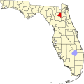
Location in Bradford County and the state of Florida
Coordinates: 30°04′58.04″N82°07′21.27″W / 30.0827889°N 82.1225750°W / 30.0827889; -82.1225750
Country Flag of the United States.svg  United States
State Flag of Florida.svg  Florida
County   Bradford
Incorporated 1905 [1]
Government
  Type Mayor-Council
   Mayor [2] [3] Jimmie Scott
   Councilors Virginia Warner,
Debra Jordan-Norman,
Emily Hoffman, and
Amy Blom
   City Clerk Lisa Harley
   City Attorney Aaron Dukes
Area
[4]
  Total
1.51 sq mi (3.92 km2)
  Land1.51 sq mi (3.92 km2)
  Water0.00 sq mi (0.00 km2)
Elevation
162 ft (49.38 m)
Population
 (2020)
  Total
636
  Density420.36/sq mi (162.32/km2)
Time zone UTC-5 (EST)
  Summer (DST) UTC-4 (EDT)
ZIP code
32058
Area code 904
FIPS code 12-39700 [5]
GNIS feature ID0285404 [6]

Lawtey is a city in Bradford County, Florida, United States. The population was 636 at the 2020 US Census, down from 730 at the 2010 US Census.

Contents

The City of Lawtey has received national attention and earned the dubious distinction of being one of only two official speed traps designated by the American Automobile Association (AAA), (the other being Waldo a few miles to the south). However, the label was removed by AAA in August 2018 after reforms by police chief Shane Bennett. [7]

Geography

The approximate coordinates for the City of Lawtey is located in northern Bradford County at 30°02′45″N82°04′20″W / 30.045804°N 82.072127°W / 30.045804; -82.072127 . [8]

It is 7 miles (11 km) north of the county seat, Starke, by U.S. Route 301. To the north it is 18 miles (29 km) to Interstate 10 at the town of Baldwin.

According to the United States Census Bureau, the city has a total area of 1.4 square miles (3.7 km2), all land.

Climate

The climate in this area is characterized by hot, humid summers and generally mild winters. According to the Köppen climate classification, the City of Lawtey has a humid subtropical climate zone (Cfa).

Demographics

Historical population
CensusPop.Note
1910 492
1920 372−24.4%
1930 55448.9%
1940 427−22.9%
1950 57634.9%
1960 6238.2%
1970 6362.1%
1980 6928.8%
1990 676−2.3%
2000 656−3.0%
2010 73011.3%
2020 636−12.9%
U.S. Decennial Census [9]

2010 and 2020 census

Lawtey racial composition
(Hispanics excluded from racial categories)
(NH = Non-Hispanic)
RacePop 2010 [10] Pop 2020 [11] % 2010% 2020
White (NH)43237559.18%58.96%
Black or African American (NH)26219835.89%31.13%
Native American or Alaska Native (NH)300.41%0.00%
Asian (NH)330.41%0.47%
Pacific Islander or Native Hawaiian (NH)500.68%0.00%
Some other race (NH)130.14%0.47%
Two or more races/Multiracial (NH)9421.23%6.60%
Hispanic or Latino (any race)15152.05%2.36%
Total730636

As of the 2020 United States census, there were 636 people, 296 households, and 219 families residing in the city. [12]

As of the 2010 United States census, there were 730 people, 365 households, and 249 families residing in the city. [13]

2000 census

As of the census [5] of 2000, there were 656 people, 259 households, and 182 families residing in the city. The population density was 476.8 inhabitants per square mile (184.1/km2). There were 295 housing units at an average density of 214.4 per square mile (82.8/km2). The racial makeup of the city was 64.79% White, 32.16% African American, 1.22% Native American, 0.46% from other races, and 1.37% from two or more races. Hispanic or Latino of any race were 1.68% of the population.

In 2000, there were 259 households, out of which 34.0% had children under the age of 18 living with them, 46.7% were married couples living together, 16.2% had a female householder with no husband present, and 29.7% were non-families. 26.3% of all households were made up of individuals, and 11.2% had someone living alone who was 65 years of age or older. The average household size was 2.53 and the average family size was 3.04.

In 2000, in the city, the population was spread out, with 27.0% under the age of 18, 8.4% from 18 to 24, 28.7% from 25 to 44, 21.0% from 45 to 64, and 14.9% who were 65 years of age or older. The median age was 36 years. For every 100 females, there were 100.0 males. For every 100 females age 18 and over, there were 95.5 males.

In 2000, the median income for a household in the city was $23,875, and the median income for a family was $27,375. The per capita income for the city was $14,122. About 21.2% of families and 22.8% of the population were below the poverty line, including 26.0% of those under age 18 and 20.9% of those age 65 or over.

Notable people

Related Research Articles

<span class="mw-page-title-main">Bradford County, Florida</span> County in Florida, United States

Bradford County is a county in the north central region of the U.S. state of Florida. As of the 2020 census, the population was 28,303. Its county seat and largest city is Starke.

<span class="mw-page-title-main">Archer, Florida</span> City in Florida, United States

Archer is a city in Alachua County, Florida, United States. It is part of the Gainesville, Florida Metropolitan Statistical Area. As of the 2020 census, the city had a population of 1,140, up from 1,118 at the 2010 census.

<span class="mw-page-title-main">Waldo, Florida</span> City in Florida, United States

Waldo is a city in Alachua County, Florida, United States. It is part of the Gainesville, Florida Metropolitan Statistical Area. As of 2020 census, the population was 846, down from 1,015 at the 2010 census.

<span class="mw-page-title-main">Callaway, Florida</span> City in Florida, United States

Callaway is a city in Bay County, Florida, United States, and is a suburb of Panama City. The population was 13,045 at the 2020 census, down from 14,405 at the 2010 census. It is part of the Panama City–Panama City Beach, Florida Metropolitan Statistical Area.

<span class="mw-page-title-main">Brooker, Florida</span> Town in Florida, United States

Brooker is a town in Bradford County, Florida, United States. It is part of the North central Florida region. The population was 322 at the 2020 census.

<span class="mw-page-title-main">Starke, Florida</span> City in Florida, United States

Starke is a city in and the county seat of Bradford County, Florida, United States. The population was 5,796 at the 2020 census. The origin of the city's name is disputed. Starke may have been named in honor of local landowner George W. Cole's fiancée's family or in honor of Madison Starke Perry, fourth governor of Florida.

<span class="mw-page-title-main">Penney Farms, Florida</span> Town in the state of Florida, United States

Penney Farms is a town in central Clay County, Florida, United States. It is part of the Jacksonville, Florida Metropolitan Statistical Area. The population was 821 at the 2020 census, up from 749 at the 2010 census.

<span class="mw-page-title-main">Bell, Florida</span> Town in Florida, United States

Bell is a town in Gilchrist County, Florida, United States. The town is situated in the northern part of the county, and located in North Florida. The population was 518 at the 2020 US Census, up from 456 at the 2010 US Census. It is part of the Gainesville, Florida Metropolitan Statistical Area.

<span class="mw-page-title-main">Fanning Springs, Florida</span> City in Florida, United States

Fanning Springs is a city in Gilchrist and Levy counties in the U.S. state of Florida. It is part of the Gainesville, Florida Metropolitan Statistical Area. The population was 1,182 at the 2020 census, up from 764 at the 2010 census.

<span class="mw-page-title-main">Inglis, Florida</span> Town in Florida, United States

Inglis is a town in Levy County, Florida, United States. It is on U.S. Highway 19 near the Cross Florida Greenway. As of the 2020 census, the town had a population of 1,476, up from 1,325 at the 2010 census. It is part of the Gainesville, Florida Metropolitan Statistical Area.

<span class="mw-page-title-main">Belleview, Florida</span> City in Florida, United States

Belleview is a city in Marion County, Florida, United States. The population was 5,413 at the 2020 census, up from 4,492 in 2010. It is part of the Ocala Metropolitan Statistical Area. The city's name comes from the French words belle and vue, meaning "beautiful view". "City with Small Town Charm" is the city's motto.

<span class="mw-page-title-main">Coral Terrace, Florida</span> Census-designated Suburb in Florida

Coral Terrace is a suburban unincorporated community and census-designated place (CDP) in Miami-Dade County, Florida, United States. It is part of the Miami metropolitan area of South Florida. The population was 23,142 at the 2020 census, down from 24,376 in 2010.

<span class="mw-page-title-main">Belleair Beach, Florida</span> City in Florida, United States

Belleair Beach is a city in Pinellas County, Florida, United States. It is part of Tampa–St. Petersburg–Clearwater Metropolitan Statistical Area, more commonly known as the Tampa Bay Area. The population was 1,633 at the 2020 census.

<span class="mw-page-title-main">Belleair Bluffs, Florida</span> City in Florida, United States

Belleair Bluffs is a city in Pinellas County, Florida, United States. It is part of the Tampa–St. Petersburg–Clearwater Metropolitan Statistical Area, more commonly known as the Tampa Bay Area. The City of Belleair Bluffs was officially incorporated as a municipality. The population was 2,311 at the 2020 census.

<span class="mw-page-title-main">Kenneth City, Florida</span> Town in the state of Florida, United States

Kenneth City is a town in southern Pinellas County, Florida, between St. Petersburg and Pinellas Park, United States. It is part of the Tampa–St. Petersburg–Clearwater Metropolitan statistical area (MSA), much more commonly known as the Tampa Bay area. The population was 5,047 at the 2020 US census.

<span class="mw-page-title-main">North Redington Beach, Florida</span> Town in the state of Florida, United States

North Redington Beach is a town in Pinellas County, Florida, United States. It is part of the Tampa–St. Petersburg–Clearwater Metropolitan Statistical Area, more commonly known as the Tampa Bay Area. The population was 1,495 at the 2020 census.

<span class="mw-page-title-main">Redington Beach, Florida</span> Town in the state of Florida, United States

Redington Beach is a town in Pinellas County, Florida, United States. It is part of the Tampa–St. Petersburg–Clearwater Metropolitan Statistical Area, more commonly called the Tampa Bay Area. The population was 1,376 at the 2020 census.

<span class="mw-page-title-main">Highland Park, Florida</span> Village in Florida, United States

Highland Park is a village in Polk County, Florida, United States. Highland Park is part of the Lakeland–Winter Haven Metropolitan Statistical Area. Its population was 251 at the 2020 US census.

<span class="mw-page-title-main">Webster, Florida</span> City in Florida, United States

Webster is a city located in Sumter County, Florida, United States. As of the 2020 census, the city had a total population of 778.

<span class="mw-page-title-main">Freeport, Florida</span> City in Florida, United States of America

Freeport is a city in Walton County, Florida, United States. It is part of the Crestview–Fort Walton Beach–Destin, Florida Metropolitan Statistical Area. As of 2020, the population recorded by the U.S. Census Bureau was 5,861, up from 1,787 at the 2010 census. Freeport is one of the fastest growing cities in Florida. After the construction of the massive group of neighborhoods, Hammock Bay, the population grew by about 2 thousand.

References

  1. "FLORIDA CITIES BY INCORPORATION YEAR WITH INCORPORATION & DISSOLUTION INFO" (PDF). www.flcities.com.
  2. "Starke, Lawtey, Hampton and Brooker City Officials". www.bradfordelections.com.
  3. "MUNICIPAL DIRECTORY: City of Lawtey". www.floridaleagueofcities.com.
  4. "2020 U.S. Gazetteer Files". United States Census Bureau. Retrieved October 31, 2021.
  5. 1 2 "U.S. Census website". United States Census Bureau . Retrieved January 31, 2008.
  6. "US Board on Geographic Names". United States Geological Survey. October 25, 2007. Retrieved January 31, 2008.
  7. "AAA Going Places Magazine | July - August 2001 | Traveler's Advocate - FL". Archived from the original on December 14, 2004. Retrieved December 18, 2004.
  8. "US Gazetteer files: 2010, 2000, and 1990". United States Census Bureau. February 12, 2011. Retrieved April 23, 2011.
  9. "Census of Population and Housing". Census.gov. Retrieved June 4, 2015.
  10. "P2 HISPANIC OR LATINO, AND NOT HISPANIC OR LATINO BY RACE - 2010: DEC Redistricting Data (PL 94-171) - Lawtey city, Florida". United States Census Bureau .
  11. "P2 HISPANIC OR LATINO, AND NOT HISPANIC OR LATINO BY RACE - 2020: DEC Redistricting Data (PL 94-171) - Lawtey city, Florida". United States Census Bureau .
  12. "S1101 HOUSEHOLDS AND FAMILIES - 2020: Lawtey city, Florida". United States Census Bureau .
  13. "S1101 HOUSEHOLDS AND FAMILIES - 2010: Lawtey city, Florida". United States Census Bureau .
  14. Newspaper article via http://fl-genweb.com/counties/mpc/marion/notables/shipman_vj.html