
Katanning is a town located 277 kilometres (172 mi) south-east of Perth, Western Australia on the Great Southern Highway. At the census of 2021 the population was 4,057. At the 2016 census, Katanning had a population of 3,687.

The Great Southern region is one of the nine regions of Western Australia, as defined by the Regional Development Commissions Act 1993, for the purposes of economic development. It is a section of the larger south coast of Western Australia and neighbouring agricultural regions.

Cranbrook is a small town in the Shire of Cranbrook in the Great Southern region of Western Australia between Katanning, Kojonup and Mount Barker, situated 320 km south of Perth. It is billed as "The Gateway to the Stirlings", referring to the nearby Stirling Range National Park. At the 2006 census, Cranbrook had a population of 280.

The townsite of Tambellup is located in the Great Southern region of Western Australia, 317 km south-east of Perth on the Great Southern Highway where it crosses the Gordon River. It is 23 km south of Broomehill.

Beverley is a town in the Wheatbelt region of Western Australia, 133 kilometres (83 mi) south-east of the state capital, Perth, between York and Brookton on the Great Southern Highway. It is on the Great Southern railway line.

Brookton is a town in the Wheatbelt region of Western Australia, 138 kilometres (86 mi) from the state capital, Perth via the Brookton Highway where it crosses the Great Southern Highway. The town is on the Great Southern railway line. It is within, and is the seat of government for, the Shire of Brookton. At the 2016 census, Brookton had a population of 975.

The Great Southern Railway was a railway company that operated from Beverley to Albany in Western Australia between 1886 and 1896. In 1896 the Western Australian Government Railways took over the company, and kept the name for the route.

Ongerup is a town and locality in the Shire of Gnowangerup, Great Southern region of Western Australia. It is 410 kilometres (250 mi) south-east of Perth and 54 kilometres (34 mi) east of Gnowangerup. At the 2021 census Ongerup had a population of 114.

Gnowangerup is a town located 61 kilometres (38 mi) south-east of Katanning in the Great Southern region of Western Australia.

Woodanilling is a small town and locality in the Shire of Woodanilling, Great Southern region of Western Australia.

The Shire of Broome is one of the four local government areas in the Kimberley region of northern Western Australia, covering an area of 55,796 square kilometres (21,543 sq mi), most of which is sparsely populated. The Shire's estimated population as at the 2016 census was 16,222 most of whom reside in the town of Broome. Many Aboriginal communities are within the Shire, notably Beagle Bay and Bardi.
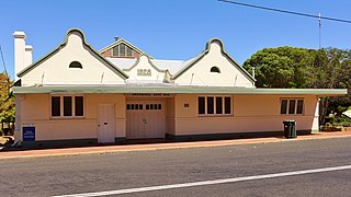
The Shire of Broomehill was a local government area in the Great Southern region of Western Australia, about 20 kilometres (12 mi) south of Katanning and about 310 kilometres (193 mi) south-southeast of the state capital, Perth. The Shire covered an area of 1,173 square kilometres (453 sq mi), and its seat of government was the town of Broomehill.
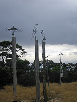
Borden is a small town and locality in the Shire of Gnowangerup, Great Southern region of Western Australia. The town is located 325 kilometres (202 mi) south east of the state capital, Perth Western Australia, and 111 kilometres (69 mi) north of Albany on Chester Pass Road. At the 2006 census, Borden and the surrounding area had a population of 164.
The Shire of Broomehill-Tambellup is a local government area in the Great Southern region of Western Australia, 320 kilometres (200 mi) south-southeast of the state capital, Perth. The Shire covers an area of 2,609.1 square kilometres (1,007.4 sq mi), and its seat of government is the town of Tambellup. It came into existence in 2008 through the amalgamation of the former Shire of Broomehill and Shire of Tambellup.

The Ongerup branch railway, also known as the Tambellup, Gnowangerup to Ongerup railway is a former railway line in the Great Southern region of Western Australia.
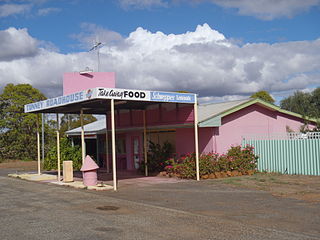
Tunney is a gazetted townsite located along the Albany Highway between Kojonup and Cranbrook, in the Shire of Cranbrook and Shire of Broomehill-Tambellup in the Great Southern region of Western Australia. The Albany Highway forms the shire boundary in this area and the area of the townsite of Tunney spans either side of the highway. Because of its location across two shires, Tunney has two postcodes, 6320 for the eastern part, located in Broomehill-Tambellup, and 6321 for the western part, located in Cranbrook.

The Great Southern Herald is a weekly newspaper published in Katanning, Western Australia. It is distributed to communities in Katanning, Kojonup, Cranbrook, Gnowangerup and Lake Grace.
Pootenup is a townsite in the Great Southern region of Western Australia. Pootenup is located in both the Shire of Cranbrook and the Shire of Broomehill-Tambellup. The Great Southern Highway forms the shire boundary in this area and the area of the townsite of Pootenup spans either side of the highway. Because of its location across two shires, Tunney has two postcodes, 6320 for the eastern part, located in Broomehill-Tambellup, and 6321 for the western part, located in Cranbrook. Much of the gazetted area of the former townsite is now covered by the Pootenup Nature Reserve.


