Brownsville, Calaveras County, California

Last updated

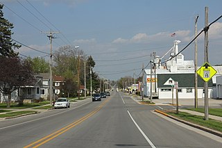
Brownsville is a former settlement in Calaveras County, California, about 1 mile (1.6 km) east of Murphys. [1] Brownsville, named for Alfred Brown, operated as a mining camp in the 1850s and 1860s. [1]

Calaveras County, California County in California

Calaveras County, officially the County of Calaveras, is a county in the northern portion of the U.S. state, California. As of the 2010 census, the population was 40,171. The county seat is San Andreas. Angels Camp is the only incorporated city in the county. Calaveras is the Spanish word for skulls; the county was reportedly named for the remains of Native Americans discovered by the Spanish explorer Captain Gabriel Moraga.

California State of the United States of America

California is a state in the Pacific Region of the United States. With 39.6 million residents, California is the most populous U.S. state and the third-largest by area. The state capital is Sacramento. The Greater Los Angeles Area and the San Francisco Bay Area are the nation's second and fifth most populous urban regions, with 18.7 million and 8.8 million residents respectively. Los Angeles is California's most populous city, and the country's second most populous, after New York City. California also has the nation's most populous county, Los Angeles County, and its largest county by area, San Bernardino County. The City and County of San Francisco is both the country's second-most densely populated major city after New York City and the fifth-most densely populated county, behind only four of the five New York City boroughs.

Murphys, California Census designated place in California, United States

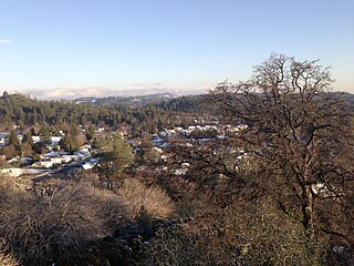
Murphys, originally Murphys New Diggings then Murphy's Camp, is an unincorporated village located in the foothills of the Sierra Nevada mountains in Calaveras County, California, United States. A former gold mining settlement, the main street today is lined with over two dozen wine tasting rooms and surrounded by local vineyards. The town is popular among tourists and transplants from the Central Valley and the San Francisco Bay Area. Murphys is also known by its colloquial nickname as "Queen of the Sierra" and is one of the more affluent communities in Calaveras County.

Related Research Articles

Mi-Wuk Village, California census-designated place in California, United States

Mi-Wuk Village is a census-designated place (CDP) in Tuolumne County, California, United States. The population was 941 at the 2010 census, down from 1,485 at the 2000 census. It was named after the Miwok Indians by the real estate developer and promoter Harry Hoeffler in 1955.

Brownsville, Minnesota City in Minnesota, United States

Brownsville is a city in Houston County, Minnesota, United States. The population was 466 at the 2010 census.

Reid Hope King, Texas Census-designated place in Texas, United States

Reid Hope King is a census-designated place (CDP) in Cameron County, Texas, United States. The population was 786 at the 2010 census. It is part of the Brownsville–Harlingen Metropolitan Statistical Area.

Brownsville, Wisconsin Village in Wisconsin, United States

Brownsville is a village in Dodge County, Wisconsin, United States. The population was 581 at the 2010 census.

Mexican Federal Highway 1 highway in Mexico

Federal Highway 1 is a free (libre) part of the federal highway corridors of Mexico, and the highway follows the length of the Baja California Peninsula from Tijuana, Baja California, in the north to Cabo San Lucas, Baja California Sur, in the south. The road connects with Via Rapida, which merges into the American Interstate 5 (I-5) at the international border south of San Ysidro, California.

Bald Mountain (California) name given to over fifty summits in California

Bald Mountain is a name given to over fifty summits in California.

Allen, California Unincorporated community in California, United States

Allen is an unincorporated community in Amador County, California. It is located on the Bear River, at an elevation of 8,113 feet.

Edwin, California Unincorporated community in California, United States

Edwin is an unincorporated community in Amador County, California. It is located 1.5 miles (2.4 km) west-northwest of Ione on the Southern Pacific Railroad, at an elevation of 282 feet.

Apex, California Unincorporated community in California, United States

Apex is an unincorporated community in El Dorado County, California. It is located on the Southern Pacific Railroad 1.25 miles (2 km) west of Placerville, at an elevation of 1883 feet.

Aukum, California Unincorporated community in California, United States

Aukum is an unincorporated community in El Dorado County, California. It is located 1 mi (1.6 km) northeast of River Pines, 1.2 mi (1.8 km) south of Mount Aukum and 8.5 mi (13.7 km) northeast of Plymouth, at an elevation of 2155 feet. The ZIP code is 95656.

Brela, California Unincorporated community in California, United States

Brela is an unincorporated community in El Dorado County, California. It is located on the Southern Pacific Railroad 1.5 miles (2 km) northeast of Latrobe, at an elevation of 988 feet.

Buckeye, El Dorado County, California Unincorporated community in California, United States

Buckeye is an unincorporated community in El Dorado County, California. It is located 2.5 miles (4.0 km) east-northeast of Georgetown, at an elevation of 2949 feet.

Croft, California Unincorporated community in California, United States

Croft is an unincorporated community in El Dorado County, California. It is located 1.5 miles (2.4 km) south of Caldor, at an elevation of 4,518 feet.

Motor City, California Unincorporated community in California, United States

Motor City is an unincorporated community in El Dorado County, California. It is located 3.5 miles (5.6 km) west of Camino at an elevation of 2323 feet.

Old Fort Jim, California Unincorporated community in California, United States

Old Fort Jim is an unincorporated community in El Dorado County, California. It is located 3 miles (4.8 km) southwest of Camino, at an elevation of 2247 feet.

Outingdale, California Unincorporated community in California, United States

Outingdale is an unincorporated community in El Dorado County, California. It is located on the Middle Fork of the Cosumnes River 4 miles (6.4 km) north of Aukum, at an elevation of 1624 feet.

Skinners, California Unincorporated community in California, United States

Skinners is an unincorporated community in El Dorado County, California. It is located 4.25 miles (6.8 km) west-northwest of Shingle Springs, at an elevation of 1362 feet.

Sly Park, California Unincorporated community in California, United States

Sly Park is an unincorporated community in El Dorado County, California. It is located in Sly Valley 13 miles (21 km) east of Placerville, at an elevation of 3560 feet.

Soapweed, California Unincorporated community in California, United States

Soapweed is an unincorporated community in El Dorado County, California. It is located 7.5 miles (12 km) northwest of Pollock Pines, at an elevation of 3596 feet.

Chili Bar is a former settlement and mining camp in El Dorado County, California. It was located on the South Fork of the American River 4.5 miles (7.2 km) east-southeast of Coloma.

References

  1. 1 2 Durham, David L. (1998). California's Geographic Names: A Gazetteer of Historic and Modern Names of the State. Clovis, Calif.: Word Dancer Press. p. 808. ISBN   1-884995-14-4.

38°7′43.2″N120°26′31.02″W / 38.128667°N 120.4419500°W / 38.128667; -120.4419500 Coordinates: 38°7′43.2″N120°26′31.02″W / 38.128667°N 120.4419500°W / 38.128667; -120.4419500

Geographic coordinate system Coordinate system

A geographic coordinate system is a coordinate system that enables every location on Earth to be specified by a set of numbers, letters or symbols. The coordinates are often chosen such that one of the numbers represents a vertical position and two or three of the numbers represent a horizontal position; alternatively, a geographic position may be expressed in a combined three-dimensional Cartesian vector. A common choice of coordinates is latitude, longitude and elevation. To specify a location on a plane requires a map projection.