Bruce, Wisconsin

Last updated

Bruce, Wisconsin
Rusk County Wisconsin Incorporated and Unincorporated areas Bruce Highlighted.svg
Location of Bruce in Rusk County, Wisconsin.
Coordinates: 45°27′26″N91°16′23″W / 45.45722°N 91.27306°W / 45.45722; -91.27306
Country Flag of the United States.svg  United States
State Flag of Wisconsin.svg  Wisconsin
County Rusk
Incorporated1901
Government
  TypeVillage
Area
[1]
  Total2.36 sq mi (6.11 km2)
  Land2.31 sq mi (5.98 km2)
  Water0.05 sq mi (0.13 km2)
Elevation
[2]
1,106 ft (337 m)
Population
 (2020) [3]
  Total781
  Estimate 
(2022) [4]
775
  Density305.46/sq mi (117.94/km2)
Time zone UTC-6 (Central (CST))
  Summer (DST) UTC-5 (CDT)
Area code(s) 715 & 534
FIPS code 55-10500 [5]
GNIS feature ID1562279 [2]
Website http://www.villageofbruce.org/

Bruce is a village in Rusk County, Wisconsin, United States. The population was 781 at the 2020 census. The village was founded in 1884 by the Sault Ste. Marie Land and Improvement Company. The land company was incorporated and led by the principal officers of the Minneapolis, Sault Ste. Marie and Atlantic Railway, which operated its ceremonial first train over its line to Bruce in November 1884. [6] [7] It was named for Alanson C. Bruce who operated a logging camp in the area. [8]

Contents

Geography

Bruce is located at 45°27′26″N91°16′23″W / 45.45722°N 91.27306°W / 45.45722; -91.27306 (45.457203, -91.272923). [9]

According to the United States Census Bureau, the village has a total area of 2.39 square miles (6.19 km2), of which 2.34 square miles (6.06 km2) is land and 0.05 square miles (0.13 km2) is water. [10]

Bruce is along U.S. Highway 8 and Wisconsin Highway 40.

Demographics

Historical population
CensusPop.Note
1910 565
1920 561−0.7%
1930 548−2.3%
1940 5968.8%
1950 86745.5%
1960 815−6.0%
1970 799−2.0%
1980 90513.3%
1990 844−6.7%
2000 787−6.8%
2010 779−1.0%
2020 7810.3%
2022 (est.)775 [4] −0.8%
U.S. Decennial Census [11]

2010 census

As of the census [3] of 2010, there were 779 people, 371 households, and 203 families living in the village. The population density was 332.9 inhabitants per square mile (128.5/km2). There were 419 housing units at an average density of 179.1 per square mile (69.2/km2). The racial makeup of the village was 99.1% White and 0.9% from two or more races. Hispanic or Latino of any race were 1.0% of the population.

There were 371 households, of which 26.1% had children under the age of 18 living with them, 38.5% were married couples living together, 11.9% had a female householder with no husband present, 4.3% had a male householder with no wife present, and 45.3% were non-families. 41.8% of all households were made up of individuals, and 23.4% had someone living alone who was 65 years of age or older. The average household size was 2.10 and the average family size was 2.85.

The median age in the village was 45.9 years. 24.1% of residents were under the age of 18; 6.4% were between the ages of 18 and 24; 18.7% were from 25 to 44; 25.5% were from 45 to 64; and 25.4% were 65 years of age or older. The gender makeup of the village was 47.2% male and 52.8% female.

2000 census

As of the census [5] of 2000, there were 787 people, 384 households, and 213 families living in the village. The population density was 343.7 people per square mile (132.7/km2). There were 407 housing units at an average density of 177.8 per square mile (68.6/km2). The racial makeup of the village was 98.98% White, 0.25% Native American, 0.13% Asian, 0.25% from other races, and 0.38% from two or more races. Hispanic or Latino of any race were 0.25% of the population.

There were 384 households, out of which 20.1% had children under the age of 18 living with them, 43.2% were married couples living together, 9.4% had a female householder with no husband present, and 44.5% were non-families. 41.1% of all households were made up of individuals, and 24.7% had someone living alone who was 65 years of age or older. The average household size was 2.05 and the average family size was 2.73.

In the village, the population was spread out, with 21.2% under the age of 18, 6.0% from 18 to 24, 22.0% from 25 to 44, 23.5% from 45 to 64, and 27.3% who were 65 years of age or older. The median age was 46 years. For every 100 females, there were 85.6 males. For every 100 females age 18 and over, there were 81.3 males.

The median income for a household in the village was $26,250, and the median income for a family was $34,861. Males had a median income of $29,732 versus $20,917 for females. The per capita income for the village was $15,226. About 4.9% of families and 9.5% of the population were below the poverty line, including 7.0% of those under age 18 and 15.5% of those age 65 or over.

A Dry Pond in the Blue Hills - Bruce, WI - September 14, 2013.jpg
A local dried lake in the fall

Related Research Articles

<span class="mw-page-title-main">Seatonville, Illinois</span> Village in Illinois, United States

Seatonville is a village in Bureau County, Illinois, United States. The population was 321 at the 2020 census. It is part of the Ottawa Micropolitan Statistical Area.

<span class="mw-page-title-main">Bruce Township, Chippewa County, Michigan</span> Civil township in Michigan, United States

Bruce Township is a civil township of Chippewa County in the U.S. state of Michigan. As of the 2020 census, the township population was 2,000.

<span class="mw-page-title-main">Rudyard Township, Michigan</span> Civil township in Michigan, United States

Rudyard Township is a civil township of Chippewa County in the U.S. state of Michigan. As of the 2020 census, the township population was 1,289. In 2023, Rudyard Township was designated the "Snowy Owl Capital of Michigan".

<span class="mw-page-title-main">Masonville Township, Michigan</span> Civil township in Michigan, United States

Masonville Township is a civil township of Delta County in the U.S. state of Michigan. The population was 1,645 at the 2020 census, down from 1,734 at the 2010 census.

<span class="mw-page-title-main">Norway, Michigan</span> City in Michigan, United States

Norway is a city in Dickinson County in the U.S. state of Michigan. The population was 2,840 at the 2020 census. It is part of the Iron Mountain, MI–WI micropolitan statistical area.

<span class="mw-page-title-main">Iron River, Michigan</span> City in Michigan, United States

Iron River is a city in Iron County in the U.S. state of Michigan. As of the 2020 census, the city population was 3,007. The city is situated at the southeast corner of Iron River Township, but is administratively autonomous.

<span class="mw-page-title-main">Outlook, Montana</span> Town in Montana, United States

Outlook is a small rural village in Sheridan County, Montana, United States. The population was 84 at the 2020 census. The village includes a post office which services Outlook and the hamlet of Raymond, as well as the surrounding countryside.

<span class="mw-page-title-main">Mylo, North Dakota</span> City in North Dakota, United States

Mylo is a city in Rolette County, North Dakota, United States. The population was 21 at the 2020 census. Other than a United States Post Office, there are no businesses or services at Mylo.

<span class="mw-page-title-main">Argonne, Wisconsin</span> Town in Wisconsin, United States

Argonne is a town in Forest County, Wisconsin, United States. The population was 512 at the 2010 census. The census-designated place of Argonne is located in the town. The unincorporated community of Wisconsin Junction is also located in the town.

<span class="mw-page-title-main">Cobb, Wisconsin</span> Village in Wisconsin, United States

Cobb is a village in Iowa County, Wisconsin, United States. The population was 458 at the 2010 census. It is part of the Madison Metropolitan Statistical Area.

<span class="mw-page-title-main">Stratford, Wisconsin</span> Village in Wisconsin, United States

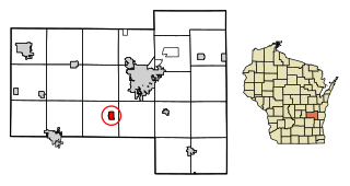
Stratford is a village in Marathon County, Wisconsin, United States. It is part of the Wausau, Wisconsin Metropolitan Statistical Area. The population was 1,578 at the 2010 census.

<span class="mw-page-title-main">Junction City, Wisconsin</span> Village in Wisconsin, United States

Junction City is a village in Portage County, Wisconsin, United States. The population was 439 at the 2010 census.

<span class="mw-page-title-main">Ladysmith, Wisconsin</span> City in Wisconsin, United States

Ladysmith is a city and the county seat of Rusk County, Wisconsin, United States. The population was 3,216 at the 2020 census.

Lomira is a town in Dodge County, Wisconsin, United States. The population was 1,228 at the 2000 census. The Village of Lomira is located within the town. The unincorporated communities of Knowles and Nasbro are located in the town.

<span class="mw-page-title-main">Oakfield, Wisconsin</span> Village in Wisconsin, United States

Oakfield is a village in Fond du Lac County, Wisconsin, United States. The population was 1,052 at the 2020 census. The village is located within the Town of Oakfield.

<span class="mw-page-title-main">Elderon, Wisconsin</span> Village in Wisconsin, United States

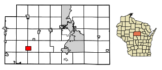
Elderon is a village in Marathon County, Wisconsin, United States. It is part of the Wausau, Wisconsin Metropolitan Statistical Area. The population was 179 at the 2010 census.

<span class="mw-page-title-main">Prentice, Wisconsin</span> Village in Wisconsin, United States

Prentice is a village in Price County, Wisconsin, United States, near where Highway 13 crosses the Jump River. The population was 660 at the 2010 census. The village is located within the Town of Prentice.

Hawkins is a town in Rusk County, Wisconsin, United States. The population was 170 at the 2000 census. The Village of Hawkins is located within the town.

<span class="mw-page-title-main">Hawkins, Wisconsin</span> Village in Wisconsin, United States

Hawkins is a village in Rusk County in north-central Wisconsin, United States. The population was 305 at the 2010 census. The village is located within the Town of Hawkins.

<span class="mw-page-title-main">Aniwa, Wisconsin</span> Village in Wisconsin, United States

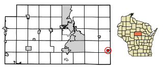
Aniwa is a village in Shawano County, Wisconsin, United States. The population was 260 at the 2010 census. The village is located within the Town of Aniwa. U.S. Route 45 runs north–south through the village.

References

  1. "2019 U.S. Gazetteer Files". United States Census Bureau. Retrieved August 7, 2020.
  2. 1 2 U.S. Geological Survey Geographic Names Information System: Bruce, Wisconsin
  3. 1 2 "U.S. Census website". United States Census Bureau . Retrieved November 18, 2012.
  4. 1 2 "Population and Housing Unit Estimates". United States Census Bureau. May 24, 2020. Retrieved May 27, 2020.
  5. 1 2 "U.S. Census website". United States Census Bureau . Retrieved January 31, 2008.
  6. "Articles of Incorporation". Saint Paul Globe. January 10, 1884. p. 2 via Newspapers.com. Open Access logo PLoS transparent.svg
  7. "A Minneapolis Road - The First Trip Over the Minneapolis and Sault Ste. Marie Railroad". Star Tribune. Minneapolis, MN. November 8, 1884. p. 4 via Newspapers.com. Open Access logo PLoS transparent.svg
  8. Callary, Edward (2016). Place Names of Wisconsin. Madison, WI: University of Wisconsin Press. p. 40. ISBN   978-0-299-30964-0.
  9. "US Gazetteer files: 2010, 2000, and 1990". United States Census Bureau. February 12, 2011. Retrieved April 23, 2011.
  10. "US Gazetteer files 2010". United States Census Bureau. Archived from the original on July 2, 2012. Retrieved November 18, 2012.
  11. "Census of Population and Housing". Census.gov. Retrieved June 4, 2015.