Brunswick Parish, New Brunswick

Last updated

Brunswick
Queens County NB - Brunswick Parish.png
Location within Queens County, New Brunswick.
Coordinates: 45°50′N64°35′W / 45.84°N 64.59°W / 45.84; -64.59
Country Flag of Canada (Pantone).svg  Canada
Province Flag of New Brunswick.svg  New Brunswick
County Queens County
Erected1816
Area
[1]
  Land703.20 km2 (271.51 sq mi)
Population
 (2021) [1]
  Total224
  Density0.3/km2 (0.8/sq mi)
  Change 2016-2021
Increase2.svg 10.3%
  Dwellings
193
Time zone UTC-4 (AST)
  Summer (DST) UTC-3 (ADT)

Brunswick is a geographic parish in the northeastern corner of Queens County, New Brunswick, Canada. [2]

Contents

Prior to the 2023 governance reform, for governance purposes it formed the local service district of the parish of Brunswick, which was a member of Kings Regional Service Commission (RSC8). [3] [4]

Origin of name

The parish was probably named in honour of the Duke of Brunswick, [5] German military leader against Napoleon, killed at the Battle of Quatre-Bras the year before the parish's erection.

History

In 1786 New Brunswick chose to set up the province's system of counties and parishes as first Act of the legislation, [6] replacing the counties established the year before through a series of Letters Patent and the township system that was inherited from Nova Scotia in 1784. The eastern boundary of Queens County passed approximately through Coles Island and the Gaspereau Forks on the Salmon River but the rear lines of Waterborough and Wickham Parishes ran approximately through Hunters Home and Chipman, extending into Westmorland and Northumberland Counties. [7] The county line was moved eastward in 1787 [8] by as much as 30 miles (48 km) in the north, created a large area that was not part of any parish; this area included large parts of Chipman and Waterborough Parishes in addition to most of modern Brunswick.

In 1816 this unassigned area was erected as Brunswick Parish; [9] because the county line hadn't been surveyed yet, any inhabitants of the New Canaan settlement were to belong to Brunswick Parish.

In 1835 part of Brunswick was included in the newly erected Chipman Parish. [10]

Boundaries

Brunswick Parish is bounded: [2] [11] [12] [13]

Communities

Communities at least partly within the parish. [11] [12] [13] bold indicates an incorporated municipality

Bodies of water

Bodies of water [lower-alpha 2] at least partly within the parish. [11] [12] [13]

Other notable places

Parks, historic sites, and other noteworthy places at least partly within the parish. [11] [12] [13] [15]

Demographics

Revised census figures based on the 2023 local governance reforms have not been released.

Access Routes

Highways and numbered routes that run through the parish, including external routes that start or finish at the parish limits: [19]

See also

Notes

  1. By the magnet of 1786, when declination at the starting point was a bit more than 14º west of north. [14]
  2. Not including brooks, ponds or coves.

Related Research Articles

<span class="mw-page-title-main">Waterborough Parish, New Brunswick</span> Parish in New Brunswick, Canada

Waterborough is a geographic parish in Queens County, New Brunswick, Canada.

<span class="mw-page-title-main">Moncton Parish, New Brunswick</span> Parish in New Brunswick, Canada

Moncton is a geographic parish in Westmorland County, New Brunswick, Canada.

<span class="mw-page-title-main">Queensbury Parish, New Brunswick</span> Parish in New Brunswick, Canada

Queensbury is a geographic parish in York County, New Brunswick, Canada.

<span class="mw-page-title-main">Sackville Parish, New Brunswick</span> Parish in New Brunswick, Canada

Sackville is a geographic parish in Westmorland County, New Brunswick, Canada.

<span class="mw-page-title-main">Newcastle Parish, New Brunswick</span> Parish in New Brunswick, Canada

Newcastle is a geographic parish in Northumberland County, New Brunswick, Canada.

<span class="mw-page-title-main">Harcourt Parish, New Brunswick</span> Parish in New Brunswick, Canada

Harcourt is a geographic parish in Kent County, New Brunswick, Canada.

<span class="mw-page-title-main">Brighton Parish, New Brunswick</span> Parish in New Brunswick, Canada

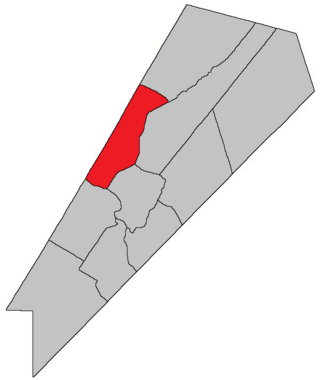
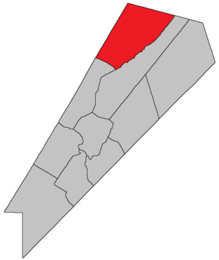
Brighton is a geographic parish in Carleton County, New Brunswick, Canada, northeast of Woodstock, extending from the eastern bank of the Saint John River to the York County line.

<span class="mw-page-title-main">Saint Marys Parish, New Brunswick</span> Parish in New Brunswick, Canada

Saint Marys is a geographic parish in York County, New Brunswick, Canada.

<span class="mw-page-title-main">Maugerville Parish, New Brunswick</span> Parish in New Brunswick, Canada

Maugerville is a geographic parish in Sunbury County, New Brunswick, Canada.

<span class="mw-page-title-main">Lincoln Parish, New Brunswick</span> Parish in New Brunswick, Canada

Lincoln is a geographic parish in Sunbury County, New Brunswick, Canada.

<span class="mw-page-title-main">Hillsborough Parish, New Brunswick</span> Parish in New Brunswick, Canada

Hillsborough is a geographic parish in eastern Albert County, New Brunswick, Canada.

<span class="mw-page-title-main">Alma Parish, New Brunswick</span> Parish in New Brunswick, Canada

Alma is a geographic parish on the Bay of Fundy in the southwestern corner of Albert County, New Brunswick, Canada.

<span class="mw-page-title-main">Salisbury Parish, New Brunswick</span> Parish in New Brunswick, Canada

Salisbury is a geographic parish in Westmorland County, New Brunswick, Canada.

<span class="mw-page-title-main">Westmorland Parish, New Brunswick</span> Parish in New Brunswick, Canada

Westmorland is a geographic parish in Westmorland County, New Brunswick, Canada.

<span class="mw-page-title-main">Sussex Parish, New Brunswick</span> Parish in New Brunswick, Canada

Sussex is a geographic parish in Kings County, New Brunswick, Canada.

<span class="mw-page-title-main">Johnston Parish, New Brunswick</span> Parish in New Brunswick, Canada

Johnston Parish is a geographic parish in Queens County, New Brunswick, Canada.

<span class="mw-page-title-main">Burton Parish, New Brunswick</span> Parish in New Brunswick, Canada

Burton is a geographic parish in Sunbury County, New Brunswick, Canada.

<span class="mw-page-title-main">Canning Parish, New Brunswick</span> Parish in New Brunswick, Canada

Canning is a geographic parish in Queens County, New Brunswick, Canada.

<span class="mw-page-title-main">Chipman Parish, New Brunswick</span> Parish in New Brunswick, Canada

Chipman is a geographic parish in Queens County, New Brunswick, Canada.

<span class="mw-page-title-main">Wickham Parish, New Brunswick</span> Parish in New Brunswick, Canada

Wickham is a geographic parish in Queens County, New Brunswick, Canada.

References

  1. 1 2 "Census Profile". Statistics Canada. 26 October 2022. Retrieved 29 October 2022.
  2. 1 2 "Chapter T-3 Territorial Division Act". Government of New Brunswick. Retrieved 13 November 2020.
  3. "New Brunswick Regulation 84-168 under the Municipalities Act (O.C. 84-582)". Government of New Brunswick. Retrieved 19 July 2020.
  4. "Communities in each of the 12 Regional Service Commissions (RSC) / Les communautés dans chacune des 12 Commissions de services régionaux (CSR)" (PDF), Government of New Brunswick, July 2017, retrieved 2 February 2021
  5. Ganong, William F. (1896). A Monograph of the Place-Nomenclature of the Province of New Brunswick. Royal Society of Canada. p. 222. Retrieved 17 March 2021.
  6. "26 Geo. III Chapter I. An Act for the better ascertaining and confirming the Boundaries of the several Counties within this Province, and for subdividing them into Towns or Parishes.". Acts of the General Assembly of His Majesty's Province of New-Brunswick, passed in the year 1786. Saint John, New Brunswick: Government of New Brunswick. 1786. pp. 3–12. Retrieved 27 March 2021.
  7. Ganong, William F. (1901). A Monograph of the Evolution of the Boundaries of the Province of New Brunswick. Royal Society of Canada. p. Map No. 35. Retrieved 25 April 2021.
  8. "27 Geo. III Chapter VII. An Act in Addition to an Act for the better ascertaining and confirming the Boundaries of the several Counties within this Province, and for Subdividing them into Towns or Parishes.". Acts of the General Assembly, of His Majesty's Province of New-Brunswick, Passed in the Year 1787. Saint John, New Brunswick: Government of New Brunswick. 1787. p. 147. Retrieved 27 March 2021.
  9. "56 Geo. III c. 27 An Act to erect into a separate Parish all the Lands in Queen's County, in the rear of the Parishes of Wickham and Waterborough.". Acts of the General Assembly of His Majesty's Province of New-Brunswick. Passed in the Year 1816. Fredericton: Government of New Brunswick. 1816. p. 51. Retrieved 27 March 2021.
  10. "5 Wm. IV c. 23 An Act for erecting parts of the Towns or Parishes of Brunswick and Canning in Queen's County into a separate Town or Parish.". Acts of the General Assembly of His Majesty's Province of New-Brunswick, Passed in the Year 1835. Fredericton: Government of New Brunswick. 1835. p. 31. Retrieved 27 March 2021.
  11. 1 2 3 4 "No. 107". Provincial Archives of New Brunswick. Department of Natural Resources and Energy Development. Retrieved 19 June 2021. Remainder of parish on maps 108, 117, 118, 129, and 130 at same site.
  12. 1 2 3 4 "315" (PDF). Transportation and Infrastructure. Government of New Brunswick. Retrieved 19 June 2021. Remainder of parish on mapbooks 316, 333–335, 354–356, 375, 376, and 395 at same site.
  13. 1 2 3 4 "Search the Canadian Geographical Names Database (CGNDB)". Government of Canada. Retrieved 19 June 2021.
  14. "Historical Magnetic Declination". National Oceanic and Atmospheric Administration. Retrieved 26 April 2021.
  15. "Explore New Brunswick's Protected Natural Areas". GeoNB. Retrieved 2 July 2021.
  16. Statistics Canada: 2001, 2006 census
  17. 2011 Statistics Canada Census Profile: Brunswick Parish, New Brunswick
  18. 1 2 "Census Profile, 2016 Census: Brunswick, Parish [Census subdivision], New Brunswick". Statistics Canada. Retrieved 28 September 2019.
  19. Atlantic Canada Back Road Atlas ISBN   978-1-55368-618-7


46°06′12″N65°32′47″W / 46.103233°N 65.546494°W / 46.103233; -65.546494 (Brunswick Parish, New Brunswick)