Salisbury Parish, New Brunswick

Last updated

Salisbury
Westmorland County NB - Salisbury Parish.png
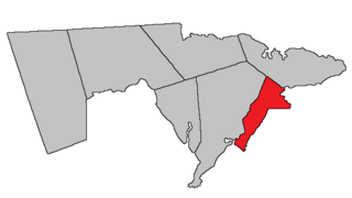
Location within Westmorland County, New Brunswick.
Coordinates: 47°40′N67°27′W / 47.67°N 67.45°W / 47.67; -67.45
Country Flag of Canada (Pantone).svg  Canada
Province Flag of New Brunswick.svg  New Brunswick
County Westmorland County
Erected1787
Area
[1]
  Land874.00 km2 (337.45 sq mi)
Population
 (2021) [1]
  Total3,377
  Density3.9/km2 (10/sq mi)
  Change 2016-2021
Decrease2.svg 0.3%
  Dwellings
1,432
Time zone UTC-4 (AST)
  Summer (DST) UTC-3 (ADT)
Figures do not include portions within the villages of Petitcodiac and Salisbury

Salisbury is a geographic parish in Westmorland County, New Brunswick, Canada. [4]

Contents

For governance purposes it is divided between the town of Salisbury, the village of Three Rivers, [5] and the Southeast rural district. [6] All are members of the Southeast Regional Service Commission. [7]

Prior to the 2023 governance reform, the parish was divided between a much smaller village of Salisbury, the village of Petitcodiac, [8] and the local service district of the parish of Salisbury, part of which was included in the special service area of Havelock Inside, which extended from the LSD of the parish of Havelock. [9] Petitcodiac is now part of Three Rivers.

Origin of name

The origin of Salisbury's name is uncertain.

William F. Ganong states it was "perhaps" due to it extending nearly to Salisbury Bay, [10] a former name of Rocher Bay. [11]

The Provincial Archives of New Brunswick gives two possibilities: Sir John Salbusbury, who accompanied Edward Cornwallis on his mission to establish Nova Scotia; or Salisbury, a city in Wiltshire, England. [12]

Boundary History

Salisbury was erected in 1787 from the unassigned land west of Hillsborough, Hopewell, and Moncton Parishes. [13]

In 1837 the western boundary of Westmorland County was altered, implicitly altering the western line of Salisbury. [14]

In 1838 the southeastern part of Salisbury was included in the newly erected Harvey Parish. [15]

In 1845 Albert County was erected from Westmorland County, [16] with the county line running through Salisbury.

In 1846 the county line with Albert was moved to its present location; the part of Salisbury south and east of the new line was transferred to Coverdale and Harvey Parishes. [17]

In 1894 the existing boundaries of Salisbury were declared retroactive to its erection. [18]

Boundaries

Salisbury Parish is bounded: [2] [19] [20]

Communities

Communities at least partly within the parish. [19] [20] [21] bold indicates an incorporated municipality

Bodies of water

Bodies of water [lower-alpha 1] at least partly within the parish. [19] [20] [21]

Other notable places

Parks, historic sites, and other noteworthy places at least partly within the parish. [19] [20] [21]

Demographics

Parish population total does not include Petitcodiac and portion within the village of Salisbury

Access routes

Highways and numbered routes that run through the parish, including external routes that start or finish at the parish limits: [27]

See also

Notes

  1. Not including brooks, ponds or coves.

Related Research Articles

<span class="mw-page-title-main">Moncton Parish, New Brunswick</span> Parish in New Brunswick, Canada

Moncton is a geographic parish in Westmorland County, New Brunswick, Canada.

<span class="mw-page-title-main">Queensbury Parish, New Brunswick</span> Parish in New Brunswick, Canada

Queensbury is a geographic parish in York County, New Brunswick, Canada.

<span class="mw-page-title-main">Coverdale Parish, New Brunswick</span> Parish in New Brunswick, Canada

Coverdale is a geographic parish in Albert County, New Brunswick, Canada, located along the Petitcodiac River opposite Moncton and Dieppe.

<span class="mw-page-title-main">Saint-Léonard Parish, New Brunswick</span> Parish in New Brunswick, Canada

Saint-Léonard is a geographic parish in Madawaska County, New Brunswick, Canada.

<span class="mw-page-title-main">Blackville Parish, New Brunswick</span> Parish in New Brunswick, Canada

Blackville is a geographic parish in Northumberland County, New Brunswick, Canada.

<span class="mw-page-title-main">Carleton Parish, New Brunswick</span> Parish in New Brunswick, Canada

Carleton is a geographic parish in Kent County, New Brunswick, Canada.

<span class="mw-page-title-main">Harcourt Parish, New Brunswick</span> Parish in New Brunswick, Canada

Harcourt is a geographic parish in Kent County, New Brunswick, Canada.

<span class="mw-page-title-main">Prince William Parish, New Brunswick</span> Parish in New Brunswick, Canada

Prince William is a geographic parish in York County, New Brunswick, Canada.

<span class="mw-page-title-main">Hillsborough Parish, New Brunswick</span> Parish in New Brunswick, Canada

Hillsborough is a geographic parish in eastern Albert County, New Brunswick, Canada.

<span class="mw-page-title-main">Elgin Parish, New Brunswick</span> Parish in New Brunswick, Canada

Elgin is a geographic parish in the interior of Albert County, New Brunswick, Canada, the only one of the county's parishes that does not border either the Bay of Fundy or the Petitcodiac River.

<span class="mw-page-title-main">Hopewell Parish, New Brunswick</span> Parish in New Brunswick, Canada

Hopewell is a geographic parish in eastern Albert County, New Brunswick, Canada.

<span class="mw-page-title-main">Harvey Parish, New Brunswick</span> Parish in New Brunswick, Canada

Harvey is a geographic parish in southern Albert County, New Brunswick, Canada.

<span class="mw-page-title-main">Alma Parish, New Brunswick</span> Parish in New Brunswick, Canada

Alma is a geographic parish on the Bay of Fundy in the southwestern corner of Albert County, New Brunswick, Canada.

<span class="mw-page-title-main">Botsford Parish, New Brunswick</span> Parish in New Brunswick, Canada

Botsford is a geographic parish in Westmorland County, New Brunswick, Canada.

<span class="mw-page-title-main">Westmorland Parish, New Brunswick</span> Parish in New Brunswick, Canada

Westmorland is a geographic parish in Westmorland County, New Brunswick, Canada.

<span class="mw-page-title-main">Dorchester Parish, New Brunswick</span> Parish in New Brunswick, Canada

Dorchester is a geographic parish in Westmorland County, New Brunswick, Canada.

<span class="mw-page-title-main">Havelock Parish, New Brunswick</span> Parish in New Brunswick, Canada

Havelock is a geographic parish in Kings County, New Brunswick, Canada.

<span class="mw-page-title-main">Sussex Parish, New Brunswick</span> Parish in New Brunswick, Canada

Sussex is a geographic parish in Kings County, New Brunswick, Canada.

<span class="mw-page-title-main">Brunswick Parish, New Brunswick</span> Parish in New Brunswick, Canada

Brunswick is a geographic parish in the northeastern corner of Queens County, New Brunswick, Canada.

<span class="mw-page-title-main">Hampton Parish, New Brunswick</span> Parish in New Brunswick, Canada

Hampton is a geographic parish in Kings County, New Brunswick, Canada.

References

  1. 1 2 "Census Profile". Statistics Canada. 26 October 2022. Retrieved 30 October 2022.
  2. 1 2 "Chapter T-3 Territorial Division Act". Government of New Brunswick. Retrieved 26 March 2023.
  3. "Chapter I-13 Interpretation Act". Government of New Brunswick. Retrieved 26 March 2023.
  4. The Territorial Division Act [2] divides the province into 152 parishes, the cities of Saint John and Fredericton, and one town of Grand Falls. The Interpretation Act [3] clarifies that parishes include any local government within their borders.
  5. "Southeast Regional Service Commission: RSC 7". Government of New Brunswick. Retrieved 26 March 2023.
  6. "Southeast Regional Service Commission: RD 7". Government of New Brunswick. Retrieved 26 March 2023.
  7. "Regions Regulation – Regional Service Delivery Act". Government of New Brunswick. 21 July 2022. Retrieved 26 March 2023.
  8. "Municipalities Order - Municipalities Act". Government of New Brunswick. 25 June 2021. Retrieved 26 March 2023.
  9. "Local Service Districts Regulation - Municipalities Act". Government of New Brunswick. 25 June 2021. Retrieved 26 March 2023.
  10. Ganong, William F. (1896). A Monograph of the Place-Nomenclature of the Province of New Brunswick. Royal Society of Canada. p. 270. Retrieved 17 March 2021.
  11. "Salisbury Bay". Geographical names in Canada. Natural Resources Canada. Retrieved 23 October 2020.
  12. "Salisbury Parish". Provincial Archives of New Brunswick. Retrieved 23 October 2020.
  13. "27 Geo. III Chapter VII. An Act in Addition to an Act for the better ascertaining and confirming the Boundaries of the several Counties within this Province, and for Subdividing them into Towns or Parishes.". Acts of the General Assembly, of His Majesty's Province of New-Brunswick, Passed in the Year 1787. Saint John, New Brunswick: Government of New Brunswick. 1787. p. 147. Retrieved 20 March 2021.
  14. "7 Wm. IV c. 35 An Act to establish a Boundary Line between the Counties of Westmorland and Saint John, and King's and Queen's Counties.". Acts of the General Assembly of His Majesty's Province of New Brunswick, Passed in the Year 1837. Fredericton: Government of New Brunswick. 1837. pp. 91–92.
  15. "1 Vic. c. 23 An Act for erecting parts of the Towns or Parishes of Hopewell and Salisbury, in the County of Westmorland, into a separate Town or Parish.". Acts of the General Assembly of Her Majesty's Province of New Brunswick, Passed in the Year 1838. Fredericton: Government of New Brunswick. 1838. pp. 72–73. Retrieved 27 March 2021.
  16. "8 Vic. c. 104 An Act to divide the County of Westmorland into two Counties, and to provide for the Government and Representation of the new County.". Acts of the General Assembly of Her Majesty's Province of New Brunswick, Passed in the Year 1846. Fredericton: Government of New Brunswick. 1846. pp. 150–152. Retrieved 27 March 2021.
  17. "9 Vic. c. 7 An Act to alter the Division Line between the Counties of Westmorland and Albert, and also certain Parish Lines in the said County of Albert.". Acts of the General Assembly of Her Majesty's Province of New Brunswick, Passed in the Year 1846. Fredericton: Government of New Brunswick. 1846. pp. 20–21. Retrieved 27 March 2021.
  18. "57 Vic. c. 36 An Act to amend Chapter 2 of the Consolidated Statutes, of 'The division of the Province into Counties, Towns and Parishes,' so far as relates to the County of Westmorland.". Acts of the General Assembly of Her Majesty's Province of New Brunswick. Passed in the Month of April, 1894. Fredericton: Government of New Brunswick. 1894. pp. 162–163. Available as a free ebook from Google Books.
  19. 1 2 3 4 "No. 108". Provincial Archives of New Brunswick. Department of Natural Resources and Energy Development. Retrieved 24 June 2021. Remainder of parish on maps 109, 118, 119, 130, and 131 at same site.
  20. 1 2 3 4 "315" (PDF). Transportation and Infrastructure. Government of New Brunswick. Retrieved 24 June 2021. Remainder of parish on mapbooks 316, 317, 335, 336, 356, 357, 377, 378, 397, and 398 at same site.
  21. 1 2 3 "Search the Canadian Geographical Names Database (CGNDB)". Government of Canada. Retrieved 3 July 2021.
  22. "Explore New Brunswick's Protected Natural Areas". GeoNB. Retrieved 3 July 2021.
  23. "New Brunswick Regulation 94-43 under the Fish and Wildlife Act (O.C. 94-231)". Government of New Brunswick. 5 June 2006. Retrieved 8 July 2021.
  24. Statistics Canada: 2001, 2006 census
  25. 2011 Statistics Canada Census Profile: Salisbury Parish, New Brunswick
  26. 1 2 "Census Profile, 2016 Census: Salisbury, Parish [Census subdivision], New Brunswick". Statistics Canada. Retrieved 5 October 2019.
  27. Atlantic Canada Back Road Atlas ISBN   978-1-55368-618-7


46°04′46″N65°10′22″W / 46.079423°N 65.172658°W / 46.079423; -65.172658 (Salisbury Parish, New Brunswick)