Cardwell Parish, New Brunswick

Last updated

Cardwell
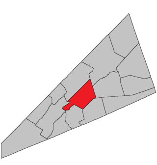
Kings County NB - Cardwell Parish.png
Location within Kings County, New Brunswick.
Coordinates: 45°50′N64°35′W / 45.84°N 64.59°W / 45.84; -64.59
Country Flag of Canada (Pantone).svg  Canada
Province Flag of New Brunswick.svg  New Brunswick
County Kings County
Erected1874
Area
[1]
  Land311.87 km2 (120.41 sq mi)
Population
 (2021) [1]
  Total1,401
  Density4.5/km2 (12/sq mi)
  Change 2016-2021
Increase2.svg 3.5%
  Dwellings
721
Time zone UTC-4 (AST)
  Summer (DST) UTC-3 (ADT)

Cardwell is a geographic parish in Kings County, New Brunswick, Canada, [4] located on the eastern border of the county.

Contents

For governance purposes, the parish is part of the Kings rural district, [5] which is a member of the Kings Regional Service Commission. [6]

Prior to the 2023 governance reform, it comprised a single local service district, which was a member of Kings Regional Service Commission (RSC8). [7]

The Census subdivision of the same name shares the parish's boundaries. [1]

Origin of name

The parish was named in honour of Viscount Cardwell, British Secretary of State for War [8] until two months before the parish's erection.

History

Cardwell was erected in 1874 from Sussex Parish. [9]

Boundaries

Cardwell Parish is bounded: [2] [10] [11] [12]

Former local service district

The entire parish formed the local service district of the parish of Cardwell, established in 1968 to assess for fire protection. Recreational and sports facilities was added to the assessment in 2012. First aid and ambulance services were listed from 1972 until the description was rewritten in 2012.

Communities

Communities at least partly within the parish; [10] [11] [12]

Bodies of water

Bodies of water [lower-alpha 2] at least partly in the parish: [10] [11] [12]

Other notable places

Parks, historic sites, and other noteworthy places at least partly in the parish. [10] [11] [12] [15]

Demographics

Revised census figures based on the 2023 local governance reforms have not been released.

Access Routes

Highways and numbered routes that run through the parish, including external routes that start or finish at the parish limits: [18]

See also

Notes

  1. By the magnet of 1840, [13] when declination in the area was about 18º west of north. [14]
  2. Not including brooks, ponds or coves.

Related Research Articles

<span class="mw-page-title-main">Dundas Parish, New Brunswick</span> Parish in Canada

Dundas is a geographic parish in Kent County, New Brunswick, Canada.

<span class="mw-page-title-main">Saint-Joseph Parish, New Brunswick</span> Parish in New Brunswick, Canada

Saint-Joseph is a geographic parish in Madawaska County, New Brunswick, Canada.

<span class="mw-page-title-main">Saint-Basile Parish, New Brunswick</span> Parish in New Brunswick, Canada

Saint-Basile is a geographic parish in Madawaska County, New Brunswick, Canada.

<span class="mw-page-title-main">Rivière-Verte Parish, New Brunswick</span> Parish in New Brunswick, Canada

Rivière-Verte is a geographic parish in Madawaska County, New Brunswick, Canada.

<span class="mw-page-title-main">Sainte-Anne Parish, New Brunswick</span> Parish in New Brunswick, Canada

Sainte-Anne is a geographic parish in Madawaska County, New Brunswick, Canada.

<span class="mw-page-title-main">Southesk Parish, New Brunswick</span> Parish in New Brunswick, Canada

Southesk is a geographic parish in Northumberland County, New Brunswick, Canada.

<span class="mw-page-title-main">Carleton Parish, New Brunswick</span> Parish in New Brunswick, Canada

Carleton is a geographic parish in Kent County, New Brunswick, Canada.

<span class="mw-page-title-main">Saint-Louis Parish, New Brunswick</span> Parish in New Brunswick, Canada

Saint-Louis is a geographic parish in Kent County, New Brunswick, Canada.

<span class="mw-page-title-main">Sainte-Marie Parish, New Brunswick</span> Parish in New Brunswick, Canada

Saint-Marie, is a geographic parish in Kent County, New Brunswick, Canada.

<span class="mw-page-title-main">Stanley Parish, New Brunswick</span> Parish in New Brunswick, Canada

Stanley is a geographic parish in York County, New Brunswick, Canada.

<span class="mw-page-title-main">Hillsborough Parish, New Brunswick</span> Parish in New Brunswick, Canada

Hillsborough is a geographic parish in eastern Albert County, New Brunswick, Canada.

<span class="mw-page-title-main">Waterford Parish, New Brunswick</span> Parish in New Brunswick, Canada

Waterford is a geographic parish in Kings County, New Brunswick, Canada.

<span class="mw-page-title-main">Hammond Parish, New Brunswick</span> Parish in New Brunswick, Canada

Hammond is a geographic parish in Kings County, New Brunswick, Canada.

<span class="mw-page-title-main">Havelock Parish, New Brunswick</span> Parish in New Brunswick, Canada

Havelock is a geographic parish in Kings County, New Brunswick, Canada.

<span class="mw-page-title-main">Studholm Parish, New Brunswick</span> Parish in New Brunswick, Canada

Studholm is a geographic parish in Kings County, New Brunswick, Canada.

<span class="mw-page-title-main">Sussex Parish, New Brunswick</span> Parish in New Brunswick, Canada

Sussex is a geographic parish in Kings County, New Brunswick, Canada.

<span class="mw-page-title-main">Norton Parish, New Brunswick</span> Parish in New Brunswick, Canada

Norton is a geographic parish in Kings County, New Brunswick, Canada.

<span class="mw-page-title-main">Hampton Parish, New Brunswick</span> Parish in New Brunswick, Canada

Hampton is a geographic parish in Kings County, New Brunswick, Canada.

<span class="mw-page-title-main">Westfield Parish, New Brunswick</span> Parish in New Brunswick, Canada

Westfield is a geographic parish in Kings County, New Brunswick, Canada.

<span class="mw-page-title-main">Kingston Parish, New Brunswick</span> Parish in New Brunswick, Canada

Kingston is a geographic parish in Kings County, New Brunswick, Canada.

References

  1. 1 2 3 "Census Profile". Statistics Canada. 26 October 2022. Retrieved 29 October 2022.
  2. 1 2 "Chapter T-3 Territorial Division Act". Government of New Brunswick. Retrieved 5 June 2023.
  3. "Chapter I-13 Interpretation Act". Government of New Brunswick. Retrieved 5 June 2023.
  4. The Territorial Division Act [2] divides the province into 152 parishes, the cities of Saint John and Fredericton, and one town of Grand Falls. The Interpretation Act [3] clarifies that parishes include any local government within their borders.
  5. "Kings rural district: RD 8". Government of New Brunswick. Retrieved 5 June 2023.
  6. "Regions Regulation – Regional Service Delivery Act". Government of New Brunswick. 21 July 2022. Retrieved 5 June 2023.
  7. "Communities in each of the 12 Regional Service Commissions (RSC) / Les communautés dans chacune des 12 Commissions de services régionaux (CSR)" (PDF), Government of New Brunswick, July 2017, retrieved 2 February 2021
  8. Ganong, William F. (1896). A Monograph of the Place-Nomenclature of the Province of New Brunswick. Royal Society of Canada. p. 225. Retrieved 17 March 2021.
  9. "37 Vic. c. 42 An Act to erect separate Parishes out of part of the Parish of Sussex, in King's County.". Acts of the General Assembly of Her Majesty's Province of New Brunswick. Passed in the Months of March & April 1874. Fredericton: Government of New Brunswick. 1874. pp. 119–121. Available as a free ebook from Google Books.
  10. 1 2 3 4 "No. 130". Provincial Archives of New Brunswick. Department of Natural Resources and Energy Development. Retrieved 14 June 2021. Remainder of parish on maps 141 and 142 at same site.
  11. 1 2 3 4 "377" (PDF). Transportation and Infrastructure. Government of New Brunswick. Retrieved 14 June 2021. Remainder of parish on mapbooks 396, 397, 415–417, and 434 at same site.
  12. 1 2 3 4 "Search the Canadian Geographical Names Database (CGNDB)". Government of Canada. Retrieved 14 June 2021.
  13. "3 Vic. c. 30 An Act for erecting a part of the Parish or Township of Sussex, in King's County, into a separate and distinct Parish or Township.". Acts of the General Assembly of Her Majesty's Province of New Brunswick, Passed in the Year 1840. Fredericton: Government of New Brunswick. 1840. pp. 14–15. Retrieved 27 March 2021.
  14. "Historical Magnetic Declination". National Oceanic and Atmospheric Administration. Retrieved 1 March 2021.
  15. "Explore New Brunswick's Protected Natural Areas". GeoNB. Retrieved 2 July 2021.
  16. Statistics Canada: 2001, 2006 census
  17. 1 2 "Census Profile, 2016 Census: Cardwell, Parish [Census subdivision], New Brunswick". Statistics Canada. Retrieved 11 September 2017.
  18. Atlantic Canada Back Road Atlas ISBN   978-1-55368-618-7


45°46′55″N65°19′19″W / 45.78201°N 65.321875°W / 45.78201; -65.321875 (Cardwell Parish, New Brunswick)