Waterford Parish, New Brunswick

Last updated

Waterford
Kings County NB - Waterford Parish.png
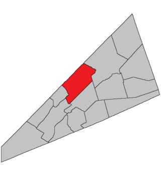
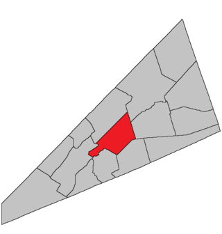
Location within Kings County, New Brunswick.
Coordinates: 45°50′N64°35′W / 45.84°N 64.59°W / 45.84; -64.59
Country Flag of Canada (Pantone).svg  Canada
Province Flag of New Brunswick.svg  New Brunswick
County Kings County
Erected1874
Area
[1]
  Land221.27 km2 (85.43 sq mi)
Population
 (2021) [1]
  Total491
  Density2.2/km2 (6/sq mi)
  Change 2016-2021
Increase2.svg 4.7%
  Dwellings
255
Time zone UTC-4 (AST)
  Summer (DST) UTC-3 (ADT)

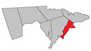
Waterford is a geographic parish in Kings County, New Brunswick, Canada. [2]

Contents

Prior to the 2023 governance reform, for governance purposes it formed the local service district of the parish of Waterford, [3] which was a member of Kings Regional Service Commission (RSC8). [4]

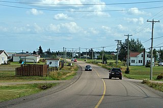
The community of Waterford has an active outdoor ice rink (Waterford Youth Centre) as well as a Community Hall that hold events such as paint nights, Thanksgiving and Christmas dinners, Easter parties and more. The area is known for its Skiing and Mountain Biking at Poley Mountain Resorts, hunting, fishing ATVing and other outdoor activities. Some local hotspots include: Friars Nose, Trout Creek Falls, Waterford Falls, Adairs Wilderness Lodge, Parlee Brook Amphitheatre Trail, Urney Covered Bridge and the Moores Mill Covered Bridge.

Origin of name

The parish was said locally to be named by Mr. A. McAfee, an Irish immigrant, for Waterford, Ireland. [5]

History

Waterford was erected in 1874 from Sussex Parish. [6]

In 1875 the boundary with Hammond Parish was altered. [7]

Boundaries

Waterford Parish is bounded: [2] [8] [9] [10]

Communities

Communities at least partly within the parish. [8] [9] [10] italics indicate a name no longer in official use

Bodies of water

Bodies of water [lower-alpha 3] at least partly in the parish. [8] [9] [10]

Other notable places

Parks, historic sites, and other noteworthy places at least partly in the parish. [8] [9] [10] [13]

Demographics

Access Routes

Highways and numbered routes that run through the parish, including external routes that start or finish at the parish limits: [17]

Notable people

See also

Notes

  1. By the magnet of 1875, [7] when declination in the area was about 21º west of north. [11]
  2. By the magnet of 1795, [12] when declination in the area was between 15º and 16º west of north. [11]
  3. Not including brooks, ponds or coves.

Related Research Articles

<span class="mw-page-title-main">Waterborough Parish, New Brunswick</span> Parish in New Brunswick, Canada

Waterborough is a geographic parish in Queens County, New Brunswick, Canada.

<span class="mw-page-title-main">Hampstead Parish, New Brunswick</span> Parish in New Brunswick, Canada

Hampstead is a geographic parish in Queens County, New Brunswick, Canada.

<span class="mw-page-title-main">Springfield Parish, New Brunswick</span> Parish in New Brunswick, Canada

Springfield is a geographic parish in Kings County, New Brunswick, Canada.

<span class="mw-page-title-main">Sackville Parish, New Brunswick</span> Parish in New Brunswick, Canada

Sackville is a geographic parish in Westmorland County, New Brunswick, Canada.

<span class="mw-page-title-main">Saint-Léonard Parish, New Brunswick</span> Parish in New Brunswick, Canada

Saint-Léonard is a geographic parish in Madawaska County, New Brunswick, Canada.

<span class="mw-page-title-main">Derby Parish, New Brunswick</span> Parish in New Brunswick, Canada

Derby is a geographic parish in Northumberland County, New Brunswick, Canada.

<span class="mw-page-title-main">Glenelg Parish, New Brunswick</span> Parish in New Brunswick, Canada

Glenelg is a geographic parish in Northumberland County, New Brunswick, Canada.

<span class="mw-page-title-main">Rogersville Parish, New Brunswick</span> Parish in New Brunswick, Canada

Rogersville is a geographic parish in Northumberland County, New Brunswick, Canada.

<span class="mw-page-title-main">Denmark Parish, New Brunswick</span> Parish in New Brunswick, Canada

Denmark is a geographic parish in Victoria County, New Brunswick, Canada.

<span class="mw-page-title-main">Wellington Parish, New Brunswick</span> Parish in New Brunswick, Canada

Wellington is a geographic parish in Kent County, New Brunswick, Canada.

<span class="mw-page-title-main">Sainte-Marie Parish, New Brunswick</span> Parish in New Brunswick, Canada

Saint-Marie, is a geographic parish in Kent County, New Brunswick, Canada.

<span class="mw-page-title-main">Elgin Parish, New Brunswick</span> Parish in New Brunswick, Canada

Elgin is a geographic parish in the interior of Albert County, New Brunswick, Canada, the only one of the county's parishes that does not border either the Bay of Fundy or the Petitcodiac River.

<span class="mw-page-title-main">Westmorland Parish, New Brunswick</span> Parish in New Brunswick, Canada

Westmorland is a geographic parish in Westmorland County, New Brunswick, Canada.

<span class="mw-page-title-main">Hammond Parish, New Brunswick</span> Parish in New Brunswick, Canada

Hammond is a geographic parish in Kings County, New Brunswick, Canada.

<span class="mw-page-title-main">Cardwell Parish, New Brunswick</span> Parish in New Brunswick, Canada

Cardwell is a geographic parish in Kings County, New Brunswick, Canada, located on the eastern border of the county.

<span class="mw-page-title-main">Studholm Parish, New Brunswick</span> Parish in New Brunswick, Canada

Studholm is a geographic parish in Kings County, New Brunswick, Canada.

<span class="mw-page-title-main">Sussex Parish, New Brunswick</span> Parish in New Brunswick, Canada

Sussex is a geographic parish in Kings County, New Brunswick, Canada.

<span class="mw-page-title-main">Norton Parish, New Brunswick</span> Parish in New Brunswick, Canada

Norton is a geographic parish in Kings County, New Brunswick, Canada.

<span class="mw-page-title-main">Hampton Parish, New Brunswick</span> Parish in New Brunswick, Canada

Hampton is a geographic parish in Kings County, New Brunswick, Canada.

<span class="mw-page-title-main">Kingston Parish, New Brunswick</span> Parish in New Brunswick, Canada

Kingston is a geographic parish in Kings County, New Brunswick, Canada.

References

  1. 1 2 "Census Profile". Statistics Canada. 26 October 2022. Retrieved 30 October 2022.
  2. 1 2 "Chapter T-3 Territorial Division Act". Government of New Brunswick. Retrieved 12 December 2020.
  3. "New Brunswick Regulation 84-168 under the Municipalities Act (O.C. 84-582)". Government of New Brunswick. Retrieved 19 July 2020.
  4. "Communities in each of the 12 Regional Service Commissions (RSC) / Les communautés dans chacune des 12 Commissions de services régionaux (CSR)" (PDF), Government of New Brunswick, July 2017, retrieved 2 February 2021
  5. Ganong, William F. (1906). Additions and Corrections to Monographs on the Place-Nomenclature, Cartography, Historic Sites, Boundaries and Settlement-origins of the Province of New Brunswick. Royal Society of Canada. p. 53. Retrieved 12 April 2021.
  6. "37 Vic. c. 42 An Act to erect separate Parishes out of part of the Parish of Sussex, in King's County.". Acts of the General Assembly of Her Majesty's Province of New Brunswick. Passed in the Months of March & April 1874. Fredericton: Government of New Brunswick. 1874. pp. 119–121. Available as a free ebook from Google Books.
  7. 1 2 "38 Vic. c. 114 An Act to establish the division line between the Parish of Hammond and the Parishes of Sussex and Waterford, in King's County.". Acts of the General Assembly of Her Majesty's Province of New Brunswick. Passed in the Month of April 1875. Fredericton: Government of New Brunswick. 1875. pp. 388–389. Available as a free ebook from Google Books.
  8. 1 2 3 4 "No. 141". Provincial Archives of New Brunswick. Department of Natural Resources and Energy Development. Retrieved 14 June 2021. Remainder of parish on maps 142, 151, and 152 at same site.
  9. 1 2 3 4 "415" (PDF). Transportation and Infrastructure. Government of New Brunswick. Retrieved 14 June 2021. Remainder of parish on mapbooks 416, 417, 433–435, and 449 at same site.
  10. 1 2 3 4 "Search the Canadian Geographical Names Database (CGNDB)". Government of Canada. Retrieved 14 June 2021.
  11. 1 2 "Historical Magnetic Declination". National Oceanic and Atmospheric Administration. Retrieved 2 March 2021.
  12. "35 Geo. III c. 3 An Act in addition to an Act intitled, 'An Act for the better Ascertaining and Confirming the Boundaries of the several Counties within this Province, and for subdividing them into Towns or Parishes.'". Acts of the General Assembly of His Majesty's Province of New-Brunswick, Passed in the Year 1795. Fredericton: Government of New Brunswick. 1795. pp. 338–340. Retrieved 27 March 2021.
  13. "Explore New Brunswick's Protected Natural Areas". GeoNB. Retrieved 2 July 2021.
  14. Statistics Canada: 2001, 2006 census
  15. 2011 Statistics Canada Census Profile: Waterford Parish, New Brunswick
  16. 1 2 "Census Profile, 2016 Census Waterford, Parish [Census subdivision], New Brunswick". Statistics Canada. Retrieved 21 September 2019.
  17. Atlantic Canada Back Road Atlas ISBN   978-1-55368-618-7
  18. Jules Heller; Nancy G. Heller (19 December 2013). North American Women Artists of the Twentieth Century: A Biographical Dictionary. Routledge. ISBN   978-1-135-63882-5.


45°41′20″N65°22′21″W / 45.688854°N 65.372515°W / 45.688854; -65.372515 (Waterford Parish, New Brunswick)