Alma Parish, New Brunswick

Last updated

Alma
Albert County NB - Alma Parish.png
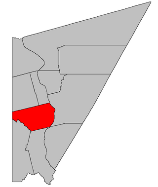
Location within Albert County.
Coordinates: 45°38′N65°00′W / 45.64°N 65.00°W / 45.64; -65.00
Country Flag of Canada (Pantone).svg  Canada
Province Flag of New Brunswick.svg  New Brunswick
County Albert County
Erected1855
Area
[1]
  Land222.74 km2 (86.00 sq mi)
Population
 (2021) [1]
  Total5
  Density0.00/km2 (0.0/sq mi)
  Change 2016-2021
Steady2.svg
  Dwellings
5
Time zone UTC-4 (AST)
  Summer (DST) UTC-3 (ADT)
Median Income*$32,995 CDN
  • Median household income, 2005 (all households)
    Figures do not include portion within the village of Alma

Alma is a geographic parish on the Bay of Fundy in the southwestern corner of Albert County, New Brunswick, Canada. [4]

Contents

For governance purposes, Alma is divided between the village of Fundy Albert [5] and the Southeast rural district, [6] both of which are members of the Southeast Regional Service Commission. [7] A small area on the western side of Fundy National Park belongs to the Fundy rural district. [lower-alpha 1]

Prior to the 2023 governance reform, the parish was divided between the village of Alma [9] and the local service district of the parish of Alma. [10] Fundy National Park was de jure part of the LSD. The village and the park are now part of Fundy Albert, the LSD part of the rural district.

The census subdivision of the same name includes all of the parish [1] except the village of Alma, which forms its own census subdivision. The population of the parish CSD is so small that census numbers are rounded to maintain privacy. Revised census figures based on the 2023 local governance reforms have not been released.

Origin of name

The parish was named for its resemblance to the heights above the Alma River, site of the Battle of Alma, a decisive British/French/Egyptian victory over Russia in 1854. [11] [12] [13]

History

Cumberland County, Nova Scotia included the territory now known as Alma Parish until the division of Nova Scotia and New Brunswick.

Initially modern Alma parish was split three ways. [14] Saint Martins Parish in Saint John County extended eastward to the boundary of Hopewell Parish, [lower-alpha 2] but ran only as far north as the extension of the northern line of Saint John County. The remainder of Alma was in Westmorland County, with Hopewell Parish extending north past Alma Parish's northern line, and the area north of Saint Martins Parish and west of Hopewell not assigned to any parish until Salisbury Parish was erected in 1787. [18] This put the community of Alma in Saint Martins Parish, Hebron in Hopewell Parish, and Teahans Corner in Salisbury Parish.

The county line between Saint John County and Westmorland County shifted westward in 1837 and the orphaned part of Saint Martins Parish was added to Hopewell [19] but not the area to its north. The next year the newly erected Harvey Parish included all of Alma. [20]

Boundaries

Alma Parish is bounded: [2] [21] [22]

Municipality

The village of Alma contains all of the parish east of Fundy National Park and south of New Ireland Road. [27]

Local service district

The local service district of the parish of Alma legally contained all of the parish not in the village of Alma; [28] in practice the national park is separate from the LSD.

The LSD was established on 1 November 1973 [29] to assess for fire protection after the village of Alma was reduced in size from including in the entire parish. [30] Ambulance service was added on 21 January 1976. [31]

In 2020, the LSD assessed for community & recreation services in addition to the basic LSD services of fire protection, police services, land use planning, emergency measures, and dog control [32] The taxing authority was 632.00 Alma.

National park

Fundy National Park is in the southwestern section of the parish, bounded on the north by Shepody Road and on east by Forty-Five Road, Lake Brook, and the Salmon River. It contains most of the parish and is under federal administration.

Communities

Communities at least partly within the parish; [21] [22] [33] bold indicates a municipality

Bodies of water

Bodies of water [lower-alpha 4] at least partly in the parish: [21] [22] [33]

Other notable places

Parks, historic sites, and other noteworthy places in the parish. [21] [22] [33] [34]

Demographics

Population

Parish population total does not include the former incorporated village of Alma. Revised census figures based on the 2023 local governance reforms have not been released.

Canada census – Alma community profile
2021 2011
Population5 (+0.0% from 2016)0 (-100.0% from 2006)
Land area222.74 km2 (86.00 sq mi)222.79 km2 (86.02 sq mi)
Population density0/km2 (0/sq mi)0.0/km2 (0/sq mi)
Median age0.0 (M: , F: )n/a (M: n/a, F: n/a)
Private dwellings5 (total)  3 (occupied)7 (total) 
Median household income$.N/A
Notes: Income & median age data for this area has been suppressed for data quality or confidentiality reasons.
References: 2021 [35] 2011 [36] earlier [37] [38]
Historical Census Data - Alma Parish, New Brunswick [39]
YearPop.±%
1996 8    
2001 5−37.5%
2006 5+0.0%
YearPop.±%
2011 0−100.0%
2016 5    
2021 5+0.0%

Access routes

Highways and numbered routes that run through the parish, including external routes that start or finish at the parish limits: [40]

See also

Notes

  1. Maps still visible as thumbnails show the current and previous governance boundaries. [8]
  2. This was probably near Owls Head rather than the modern boundary of Alma and Harvey Parish. William Francis Ganong's adaptation [15] of the 1780 map of region by Joseph Frederick Wallet DesBarres shows the boundary approximately at Owls Head and a grant to Hambleton Redpath at Owls Head [16] in 1831 gives the parish as Hopewell. [17]
  3. By the magnet of 1847, [23] when declination in the area was between 19º and 20º west of north. [24] The Territorial Division Act clause referring to magnetic direction bearings was later changed to the problematic wording "by the magnet of the year in which the County or Parish was erected", [25] which ignores lines changed after the erection of the county or parish, before being omitted in the 1952 [26] and 1973 Revised Statutes. [2]
  4. Not including brooks, ponds, or coves.

Related Research Articles

<span class="mw-page-title-main">Beresford Parish, New Brunswick</span> Parish in New Brunswick, Canada

Beresford is a geographic parish in Gloucester County, New Brunswick, Canada.

<span class="mw-page-title-main">Coverdale Parish, New Brunswick</span> Parish in New Brunswick, Canada

Coverdale is a geographic parish in Albert County, New Brunswick, Canada, located along the Petitcodiac River opposite Moncton and Dieppe.

<span class="mw-page-title-main">Harcourt Parish, New Brunswick</span> Parish in New Brunswick, Canada

Harcourt is a geographic parish in Kent County, New Brunswick, Canada.

<span class="mw-page-title-main">Kent Parish, New Brunswick</span> Parish in New Brunswick, Canada

Kent is a geographic parish in the northeastern corner of Carleton County, New Brunswick, Canada.

<span class="mw-page-title-main">Wakefield Parish, New Brunswick</span> Parish in New Brunswick, Canada

Wakefield is a geographic parish in Carleton County, New Brunswick, Canada, located north on the west bank of the Saint John River north of Woodstock.

<span class="mw-page-title-main">Hillsborough Parish, New Brunswick</span> Parish in New Brunswick, Canada

Hillsborough is a geographic parish in eastern Albert County, New Brunswick, Canada.

<span class="mw-page-title-main">Elgin Parish, New Brunswick</span> Parish in New Brunswick, Canada

Elgin is a geographic parish in the interior of Albert County, New Brunswick, Canada, the only one of the county's parishes that does not border either the Bay of Fundy or the Petitcodiac River.

<span class="mw-page-title-main">Hopewell Parish, New Brunswick</span> Parish in New Brunswick, Canada

Hopewell is a geographic parish in eastern Albert County, New Brunswick, Canada.

<span class="mw-page-title-main">Harvey Parish, New Brunswick</span> Parish in New Brunswick, Canada

Harvey is a geographic parish in southern Albert County, New Brunswick, Canada.

<span class="mw-page-title-main">Salisbury Parish, New Brunswick</span> Parish in New Brunswick, Canada

Salisbury is a geographic parish in Westmorland County, New Brunswick, Canada.

<span class="mw-page-title-main">Westmorland Parish, New Brunswick</span> Parish in New Brunswick, Canada

Westmorland is a geographic parish in Westmorland County, New Brunswick, Canada.

<span class="mw-page-title-main">Saint Martins Parish, New Brunswick</span> Parish in New Brunswick, Canada

Saint Martins is a geographic parish in Saint John County, New Brunswick, Canada.

<span class="mw-page-title-main">Simonds Parish, Saint John County, New Brunswick</span> Parish in New Brunswick, Canada

Simonds is a geographic parish in Saint John County, New Brunswick, Canada.

<span class="mw-page-title-main">Lepreau Parish, New Brunswick</span> Parish in Canada

Lepreau is a geographic parish in Charlotte County, New Brunswick, Canada, west of Saint John.

<span class="mw-page-title-main">Pennfield Parish, New Brunswick</span> Parish in Canada

Pennfield is a geographic parish in Charlotte County, New Brunswick, Canada, located west of Saint John located east of St. George and west of Saint John.

<span class="mw-page-title-main">West Isles Parish, New Brunswick</span> Parish in Canada

West Isles is a geographic parish in Charlotte County, New Brunswick, Canada.

<span class="mw-page-title-main">Saint George Parish, New Brunswick</span> Parish in Canada

Saint George is a geographic parish in Charlotte County, New Brunswick, Canada, located between St. Stephen and Saint John.

<span class="mw-page-title-main">Saint Patrick Parish, New Brunswick</span> Parish in Canada

Saint Patrick is a geographic parish in Charlotte County, New Brunswick, Canada, located west of St. George and Saint Andrews.

<span class="mw-page-title-main">Saint Stephen Parish, New Brunswick</span> Parish in Canada

Saint Stephen is a geographic parish in Charlotte County, New Brunswick, Canada, located in the southwestern corner of the province.

<span class="mw-page-title-main">Saint David Parish, New Brunswick</span> Parish in Canada

Saint David is a geographic parish in Charlotte County, New Brunswick, Canada, located northeast of St. Stephen and northwest of Saint Andrews.

References

  1. 1 2 3 "Census Profile". Statistics Canada. 26 October 2022. Retrieved 29 October 2022.
  2. 1 2 3 "Chapter T-3 Territorial Division Act". Government of New Brunswick. Retrieved 26 March 2023.
  3. "Chapter I-13 Interpretation Act". Government of New Brunswick. Retrieved 26 March 2023.
  4. The Territorial Division Act [2] divides the province into 152 parishes, the cities of Saint John and Fredericton, and one town of Grand Falls. The Interpretation Act [3] clarifies that parishes include any local government within their borders.
  5. "Southeast Regional Service Commission: RSC 7". Government of New Brunswick. Retrieved 26 March 2023.
  6. "Southeast Regional Service Commission: RD 7". Government of New Brunswick. Retrieved 26 March 2023.
  7. "Regions Regulation – Regional Service Delivery Act". Government of New Brunswick. 21 July 2022. Retrieved 26 March 2023.
  8. "RSC 9 Fundy Regional Service Commission RSC 9". Government of New Brunswick. Retrieved 26 March 2023.
  9. "Municipalities Order - Municipalities Act". Government of New Brunswick. 25 June 2021. Retrieved 26 March 2023.
  10. "Local Service Districts Regulation - Municipalities Act". Government of New Brunswick. 25 June 2021. Retrieved 26 March 2023.
  11. Ganong, William F. (1896). A Monograph of the Place-Nomenclature of the Province of New Brunswick. Royal Society of Canada. p. 217. Retrieved 17 March 2021..
  12. Ganong, William F. (1906). Additions and Corrections to Monographs on the Place-Nomenclature, Cartography, Historic Sites, Boundaries and Settlement-origins of the Province of New Brunswick. Royal Society of Canada. p. 14. Retrieved 12 April 2021.
  13. "Alma Parish". Provincial Archives of New Brunswick. Retrieved 13 April 2021.
  14. "26 Geo. III Chapter I. An Act for the better ascertaining and confirming the Boundaries of the several Counties within this Province, and for subdividing them into Towns or Parishes.". Acts of the General Assembly of His Majesty's Province of New-Brunswick, passed in the year 1786. Saint John, New Brunswick: Government of New Brunswick. 1786. pp. 3–12. Retrieved 27 March 2021.
  15. Ganong, William F. (1901). A Monograph of the Evolution of the Boundaries of the Province of New Brunswick. Royal Society of Canada. p. 430. Retrieved 27 March 2021.
  16. "Crown Grant Reference Map Viewer". GeoNB. Retrieved 31 March 2021.
  17. "Index to New Brunswick Land Grants, 1784 - 1997 (RS686)". Provincial Archives of New Brunswick. Retrieved 31 March 2021.
  18. "27 Geo. III Chapter VII. An Act in Addition to an Act for the better ascertaining and confirming the Boundaries of the several Counties within this Province, and for Subdividing them into Towns or Parishes.". Acts of the General Assembly, of His Majesty's Province of New-Brunswick, Passed in the Year 1787. Saint John, New Brunswick: Government of New Brunswick. 1787. p. 147. Retrieved 27 March 2021.
  19. "7 Wm. IV c. 35 An Act to establish a Boundary Line between the Counties of Westmorland and Saint John, and King's and Queen's Counties.". Acts of the General Assembly of His Majesty's Province of New Brunswick, Passed in the Year 1837. Fredericton: Government of New Brunswick. 1837. pp. 91–92. Retrieved 27 March 2021.
  20. "1 Vic. c. 23 An Act for erecting parts of the Towns or Parishes of Hopewell and Salisbury, in the County of Westmorland, into a separate Town or Parish.". Acts of the General Assembly of Her Majesty's Province of New Brunswick, Passed in the Year 1838. Fredericton: Government of New Brunswick. 1838. pp. 72–73.
  21. 1 2 3 4 "No. 142". Provincial Archives of New Brunswick. Department of Natural Resources and Energy Development. Retrieved 24 May 2021. Remainder of parish on map 152 at same site.
  22. 1 2 3 4 "417" (PDF). Transportation and Infrastructure. Government of New Brunswick. Retrieved 24 May 2021. Remainder of parish on mapbooks 418, 435, 436, 450, and 451 at same site.
  23. "Chapter 2 The Division of the Province into Counties, Towns, and Parishes.". The Consolidated Statutes of New Brunswick. Fredericton: Government of New Brunswick. 1877. pp. 56–85. Available as a free ebook from Google Books.
  24. "Historical Magnetic Declination". National Oceanic and Atmospheric Administration. Retrieved 24 May 2021.
  25. "59 Vic. c. 8 An Act to Revise and Codify an Act to Provide for the Division of the Province into Counties, Towns and Parishes.". Acts of the General Assembly of Her Majesty's Province of New Brunswick. Passed in the Month of March, 1896. Fredericton: Government of New Brunswick. 1896. pp. 86–123. Available as a free ebook from Google Books.
  26. "Chapter 227 Territorial Division Act". The Revised Statutes of New Brunswick 1952 Volume III. Fredericton: Government of New Brunswick. 1952. pp. 3725–3771.
  27. "New Brunswick Regulation 85-6 under the Municipalities Act (O.C. 85-45)". Government of New Brunswick. Retrieved 11 December 2020. The names of the Shepody Road and Barrett Road have changed since 1973.
  28. "New Brunswick Regulation 84-168 under the Municipalities Act (O.C. 84-582)". Government of New Brunswick. Retrieved 11 December 2020.
  29. "Regulation 73–122 under the Municipalities Act (O. C. 73–846)". The Royal Gazette. 131. Fredericton: 1014–1015. 24 October 1973.
  30. "Regulation 73–113 under the Municipalities Act (O. C. 73–809)". The Royal Gazette. 131. Fredericton: 986–987. 17 October 1973.
  31. "Regulation 76–17 under the Municipalities Act (O. C. 76–71)". The Royal Gazette. 134. Fredericton: 91. 28 January 1976.
  32. "2020 Local Government Statistics for New Brunswick" (PDF). Department of Environment and Local Government. p. 55. Retrieved 11 December 2020.
  33. 1 2 3 "Canadian Geographical Names Database". Government of Canada. Retrieved 8 June 2021.
  34. "Explore New Brunswick's Protected Natural Areas". GeoNB. Retrieved 1 July 2021.
  35. "2021 Community Profiles". 2021 Canadian Census . Statistics Canada. 4 February 2022. Retrieved 19 October 2023.
  36. "2011 Community Profiles". 2011 Canadian Census . Statistics Canada. 21 March 2019. Retrieved 28 April 2014.
  37. "2006 Community Profiles". 2006 Canadian Census . Statistics Canada. 20 August 2019.
  38. "2001 Community Profiles". 2001 Canadian Census . Statistics Canada. 18 July 2021.
  39. Statistics Canada: 1996, 2001, 2006, 2011 census
  40. Atlantic Canada Back Road Atlas ISBN   978-1-55368-618-7