Colbert County is a county located in the northwestern part of the U.S. state of Alabama. As of the 2020 census the county's population was 57,227. The county seat is Tuscumbia. The largest city is Muscle Shoals.

Franklin County is a county located in the northeastern part of the U.S. state of Georgia. As of the 2020 census, the population was 23,424. The county seat is Carnesville. On February 25, 1784, Franklin and Washington became Georgia's eighth and ninth counties, with Franklin named in honor of patriot Benjamin Franklin.

Midway is a town located in eastern Bullock County, Alabama, United States. At the 2020 census, the population was 421.

Union Springs is a city in and county seat of Bullock County, Alabama, United States. The population was 3,980 at the 2010 census.

Jacksonville is a city in Calhoun County, Alabama, United States. As of the 2010 census the population was 12,548, which is a 49% increase since 2000. It is included in the Anniston-Oxford Metropolitan Statistical Area. The city is home to Jacksonville State University, which is a center of commerce and one of the largest employers in the area.

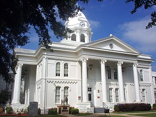
Centre is a city in Cherokee County, Alabama, United States. At the 2020 census, the population was 3,587. The city is the county seat of Cherokee County.

Ozark is a city in and the county seat of Dale County, Alabama. As of the 2010 census, the population of the city was 14,907.
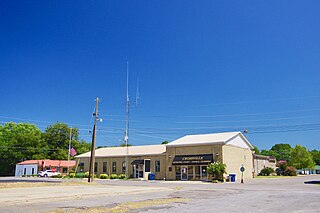
Crossville is a town in DeKalb County, Alabama, United States. At the 2010 census the population was 1,862, up from 1,431 in 2000. Crossville is located atop Sand Mountain, a southern extension of the Cumberland Plateau.
Rainsville is a city in DeKalb County, Alabama, United States. At the 2010 census the population was 4,948, up from 4,499 in 2000. Rainsville is located on top of Sand Mountain, a southern extension of the Cumberland Plateau.

Dutton is a town in Jackson County, Alabama, United States. It was incorporated in 1963. As of the 2010 census, the population of the town was 315, up from 310 in 2000. Dutton is located atop Sand Mountain.

Hollywood is a town in Jackson County, northeast Alabama, United States. In 2020, the census showed a population of 914 residents. Hollywood is considered a suburb of Scottsboro, the county seat. The town is the site of the Tennessee Valley Authority's never-completed Bellefonte Nuclear Generating Station. The TVA sold the plant, and as of 2018, it is to be developed by private interests.
Pisgah is a town in Jackson County, Alabama, United States, and is included in the Huntsville-Decatur Combined Statistical Area. It incorporated in 1947. As of the 2020 census, the population of the town was 681, down from 722 in 2010. Pisgah is located atop Sand Mountain.

Section is a town in Jackson County, Alabama, United States and is included in the Chattanooga-Cleveland-Dalton, TN-GA-AL Combined Statistical Area. As of the 2010 census, the population of the town was 770, an increase of one person (769) from 2000. Section is located on top of Sand Mountain.

Stevenson is a city in Jackson County, Alabama, United States, and is included in the Chattanooga-Cleveland-Dalton, TN-GA-AL Combined Statistical Area. Sources listed either 1866 or 1867 as the year of incorporation, but that seems to conflict with the dates given for the town being granted a charter. It did not first appear on the U.S. Census until 1880, where it was the second largest town in Jackson County behind Scottsboro. Since 1900, it has been the third largest town behind either Scottsboro and Bridgeport or vice versa. At the 2020 census, the population of the city was 1,955, down from 2,046 in 2010.

Roanoke is a city in Randolph County, which is in the Piedmont region of eastern Alabama, United States. As of the 2020 census, the population of the city was 5,311, down from 6,074 in 2010 and 6,563 in 2000.

Summit is a census-designated place (CDP) in Pima County, Arizona, United States. The population was 3,702 at the 2000 census.

Jefferson is a city in Jackson County, Georgia, United States. The population was 9,432 at the 2010 census, up from 3,825 at the 2000 census. As of 2019 the estimated population was 12,032. The city is the county seat of Jackson County.

White Lake is a town in Bladen County, North Carolina, United States. The population was 802 at the 2010 census, up from 529 in 2000.

Flat Rock is an unincorporated community in Jackson County, Alabama, United States. The Flat Rock post office was established in 1912.
Higdon is an unincorporated community in Jackson County, Alabama, United States.


