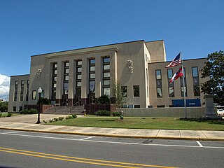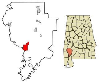
Clarke County is a county located in the southwestern part of the U.S. state of Alabama. As of the 2010 census, the population was 25,833. The county seat is Grove Hill. The county was created by the legislature of the Mississippi Territory in 1812. It is named in honor of General John Clarke of Georgia, who was later elected governor of that state.

Jackson County is the northeasternmost county in the U.S. state of Alabama. As of the 2010 census, the population was 53,227. The county seat is Scottsboro. The county was named for Andrew Jackson, general in the United States Army and afterward President of the United States of America. Jackson County is a prohibition or dry county, but three cities within the county are "wet", allowing alcohol sales. Jackson County comprises the Scottsboro, AL Micropolitan Statistical Area. This is included in the Chattanooga-Cleveland-Dalton, TN-GA-AL Combined Statistical Area. It is the site of Russell Cave National Monument, an archeological site with evidence of 8,000 years of human occupation in the Southeast.

Jackson County is a county located in the U.S. state of Mississippi. As of the 2010 census, the population was 139,668, making it the fifth-most populous county in Mississippi. Its county seat is Pascagoula. The county was named for Andrew Jackson, general in the United States Army and afterward President of the United States.

Jackson is a city in Clarke County, Alabama, United States. The population was 5,228 at the 2010 census. It was one of three wet settlements in an otherwise-dry county.

Pikeville is an unincorporated community in northern Jackson County, Alabama, United States. Pikeville is named for the fact that the community was located at the head of a turnpike.
State Route 146 (SR 146) is a 6.334-mile-long (10.194 km) state highway that exists entirely within Jackson County in the northeastern part of the U.S. state of Alabama. The western terminus of the highway is at an intersection with SR 65 in Swaim, an unincorporated community. The eastern terminus of the highway is at an intersection with SR 79 between Skyline and Hytop.
State Route 65 (SR 65) is a 27.540-mile-long (44.321 km) state highway in western Jackson County, in the U.S. state of Alabama. The southern terminus of the highway is at an intersection with U.S. Route 72 (US 72) at Paint Rock. The northern terminus of the highway is at the Tennessee state line, north of Francisco. North of the state line, the highway continues as Tennessee State Route 97.

Higdon is an unincorporated community in Jackson County, Alabama, United States.

Long Island is an unincorporated community in the northeastern corner of Jackson County, Alabama, United States. Long Island appears on the Bridgeport U.S. Geological Survey Map. It was reportedly named Carpenter for a family that lived there prior to 1852, when it was given the English form of the original Cherokee name of the village on the long island in the Tennessee River dating from 1783.

Liberty Hill is an unincorporated community in Jackson County, Alabama, United States. Liberty Hill is located on County Route 14, 7.6 miles (12.2 km) east-southeast of Stevenson.

Estillfork is an unincorporated community in Jackson County, Alabama, United States. It is located in a rugged area at the head of the Paint Rock Valley in northern Jackson County. Just south of the community, the stream with which it shares its name, Estill Fork, joins Hurricane Creek to form the Paint Rock River. The Cumberland Plateau rises immediately to the east, and the Alabama-Tennessee state line passes a few miles to the north.

Trenton is an unincorporated community in Jackson County, Alabama, United States. It is located on Alabama State Route 65, 7.7 miles (12.4 km) east-northeast of Gurley in the Paint Rock Valley. Trenton had a post office until it closed on November 5, 2011; it still has its own ZIP code, 35774.

Rash, also known as Coffeys Store, is an unincorporated community in Jackson County, Alabama, United States.

Bolivar, also known as Widows, is an unincorporated community in northern Jackson County, Alabama, United States. It is located on Alabama State Route 277, halfway between Bridgeport and Stevenson. It was originally called New Bolivar after many of the citizens of the old community of Bolivar, which was located near the current community of Edgefield near Stevenson, relocated to the railroad well after it was completed through the area in 1854. The old community faded away and New Bolivar never really grew. On original maps from the 1880s, New Bolivar was located where the former North Jackson Hospital stands on Alabama Highway 277.

Francisco is an unincorporated community in northern Jackson County, Alabama, United States. It is located on Alabama State Route 65, 19.1 miles (30.7 km) northwest of Skyline.

Larkin is an unincorporated community in northern Jackson County, Alabama, United States. It is located on Alabama State Route 65, 12.4 miles (20.0 km) northwest of Skyline.

Lim Rock, also known as Limrock, Lime Rock, Boyds Switch, or Boyd Switch, is an unincorporated community in southern Jackson County, Alabama, United States. It is located on Alabama State Route 35 halfway between Scottsboro and Woodville.

Screamer is an unincorporated community in Henry County, Alabama, United States. Screamer is located on Alabama State Route 95, 12.4 miles (20.0 km) north-northeast of Abbeville. The original line established between the Creek Indians and the United States in the Treaty of Fort Jackson ran through Screamer. The Treaty of Cusseta ceded the boundary line north, allowing Henry County to gain land.

Marlow is an unincorporated community in Baldwin County, Alabama, United States.

Riderwood is an unincorporated community in Choctaw County, Alabama, United States.


