
Thurston Island is an ice-covered, glacially dissected island, 215 km (134 mi) long, 90 km (56 mi) wide and 15,700 km2 (6,062 sq mi) in area, lying a short way off the northwest end of Ellsworth Land, Antarctica. It is the third largest island of Antarctica, after Alexander Island and Berkner Island.

Marie Byrd Land is the portion of West Antarctica lying east of the Ross Ice Shelf and the Ross Sea and south of the Pacific Ocean, extending eastward approximately to a line between the head of the Ross Ice Shelf and Eights Coast. It stretches between 158°W and 103°24'W. The inclusion of the area between the Rockefeller Plateau and Eights Coast is based upon the leading role of the American Rear Admiral Richard E. Byrd in the exploration of this area. The name was originally applied by Admiral Byrd in 1929, in honor of his wife, to the northwestern part of the area, the part that was explored in that year.

Borchgrevink Glacier is a large glacier in the Victory Mountains, Victoria Land, draining south between Malta Plateau and Daniell Peninsula, and thence projecting into Glacier Strait, Ross Sea, as a floating glacier tongue, the Borchgrevink Glacier Tongue, just south of Cape Jones. It was named by the New Zealand Geological Survey Antarctic Expedition, 1957–58, for Carsten Borchgrevink, leader of the British Antarctic Expedition, 1898–1900. Borchgrevink visited the area in February 1900 and first observed the seaward portion of the glacier.

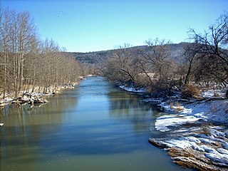
The Paint Rock River is a 58.7-mile-long (94.5 km) tributary of the Tennessee River in northern Alabama in the United States. Its tributaries also drain a portion of south-central Tennessee.

Petit Bois Island is a barrier island off the Mississippi Gulf Coast, south of Pascagoula, and one of the Mississippi–Alabama barrier islands. It is part of Jackson County, Mississippi. Since 1971 it has been a part of Gulf Islands National Seashore, administered by the U.S. National Park Service.
The Black River is a 41.1-mile-long (66.1 km) river on the Upper Peninsula of the U.S. state of Michigan, flowing mostly in Gogebic County into Lake Superior at 46°40′03″N90°02′57″W. Its source at 46°18′54″N90°01′15″W is a boreal wetland on the border with Iron County, Wisconsin. The northern section of the river, 14 miles (23 km) within the boundaries of the Ottawa National Forest, was designated a National Wild and Scenic River in 1992.
The Cowanesque River is a 41.4-mile-long (66.6 km) tributary of the Tioga River in Potter and Tioga counties, Pennsylvania, and Steuben County, New York, in the United States. It joins the Tioga River soon after crossing from Pennsylvania into New York, near the borough of Lawrenceville, Pennsylvania.

Bellefonte is a ghost town in Jackson County, Alabama, United States, near the site of the Bellefonte Nuclear Generating Station. It is located roughly two miles southeast of Hollywood, Alabama.

Manada Creek is a 17.0-mile-long (27.4 km) tributary of Swatara Creek in Dauphin County, Pennsylvania in the United States. The watershed drains approximately 32 sq mi (83 km). The name is derived the Lenape word "menatey", meaning "island".
The geologic map of Georgia is a special-purpose map made to show geological features. Rock units or geologic strata are shown by colors or symbols to indicate where they are exposed at the surface. Structural features such as faults and shear zones are also shown. Since the first national geological map, in 1809, there have been numerous maps which included the geology of Georgia. The first Georgia specific geologic map was created in 1825. The most recent state-produced geologic map of Georgia, by the Georgia Department of Natural Resources is 1:500,000 scale, and was created in 1976 by the department's Georgia Geological Survey. It was generated from a base map produced by the United States Geological Survey. The state geologist and Director of the Geological Survey of Georgia was Sam M. Pickering, Jr. Since 1976, several geological maps of Georgia, featuring the state's five distinct geologic regions, have been produced by the federal government.

Carpenter's Station, Alabama, is a community located in Baldwin County, Alabama. It appears as "Carpenter" on the Bay Minette South U.S. Geological Survey Map.

Carpenter is an unincorporated community in New Castle County, Delaware, United States. Carpenter is located where Delaware Route 92 crosses the former Baltimore & Ohio Railroad, 6.5 miles northeast of Wilmington.
Fort Strother was a stockade fort at Ten Islands in the Mississippi Territory, in what is today St. Clair County, Alabama. It was located on a bluff of the Coosa River, near the modern Neely Henry Dam in Ragland, Alabama. The fort was built by General Andrew Jackson and several thousand militiamen in November 1813, during the Creek War and was named for Captain John Strother, Jackson's chief cartographer. The fort was rectangular in shape and had blockhouses at each corner. It also included a supply building, eight hospital huts, and twenty-five tents.

Perdido, also known as Perdido Station, is an unincorporated community in Baldwin County, Alabama, United States. Perdido is located along County Route 61, 12.2 miles (19.6 km) northeast of Bay Minette. Perdido has a post office with ZIP code 36562. It has an elementary school, Perdido School, which is part of the Baldwin County Board of Education.
Nokomis is an unincorporated community in Escambia County, Alabama, United States. Nokomis is located along U.S. Route 31 and a CSX Transportation line 4.3 miles (6.9 km) west-southwest of Atmore. Nokomis has the distinction of having boundaries in three U.S. counties: Escambia, Alabama; Escambia, Florida; and Baldwin, Alabama.
Liberty Hill is an unincorporated community in Jackson County, Alabama, United States. Liberty Hill is located on County Route 14, 7.6 miles (12.2 km) east-southeast of Stevenson.
Bolivar, also known as Widows, is an unincorporated community in northern Jackson County, Alabama, United States. It is located on Alabama State Route 277, halfway between Bridgeport and Stevenson. It was originally called New Bolivar after many of the citizens of the old community of Bolivar, which was located near the current community of Edgefield near Stevenson, relocated to the railroad well after it was completed through the area in 1854. The old community faded away and New Bolivar never really grew. On original maps from the 1880s, New Bolivar was located where the former North Jackson Hospital stands on Alabama Highway 277.
Palmetto is an unincorporated community in northeastern Pickens County, Alabama, United States.
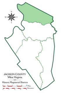
Grant District, formerly Grant Magisterial District, is one of five historic magisterial districts in Jackson County, West Virginia. The district was originally established as a civil township in 1863, and converted into a magisterial district in 1872. When Jackson County was redistricted in the 1990s, the area of Grant District was included in the new Northern Magisterial District. However, the county's historic magisterial districts continue to exist in the form of tax districts, serving all of their former administrative functions except for the election of county officials.
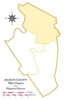
The Northern Magisterial District is one of three magisterial districts in Jackson County, West Virginia. It was established during a process of redistricting undertaken in the 1990s. In 2010, 8,753 people lived in the district.


