
Montgomery County is a county located in the U.S. state of Alabama. As of the 2020 census, its population was 228,954, making it the seventh-most populous county in Alabama. Its county seat is Montgomery, the state capital. Montgomery County is included in the Montgomery Metropolitan Statistical Area.

Cherokee County, Alabama is a county located in the northeastern part of the U.S. state of Alabama. As of the 2020 census, the population was 24,971. Its county seat is Centre. The county is named for the Cherokee tribe.
Colbert County is a county located in the northwestern part of the U.S. state of Alabama. As of the 2020 census the county's population was 57,227. The county seat is Tuscumbia. The largest city is Muscle Shoals.
DeKalb County is a county in the northeastern part of the U.S. state of Alabama. As of the 2020 census, the population was 71,608. Its county seat is Fort Payne, and it is named after Major General Baron Johann de Kalb. DeKalb County is part of the Huntsville-Decatur-Albertville, AL Combined Statistical Area.

Geneva County is a county located in the southeastern part of the U.S. state of Alabama. As of the 2020 census, the population was 26,659. Its county seat is Geneva. The county was named after its county seat, which in turn was named after Geneva, New York which was named after Geneva, Switzerland, by Walter H. Yonge, an early town resident and Swiss native. Geneva County is a dry county. However, beer and wine are sold in the city limits of Geneva, Samson, Slocomb, and most recently in Hartford, after residents voted to become wet in a 2022 election.
Jackson County is the northeasternmost county in the U.S. state of Alabama. As of the 2020 census, the population was 52,579. The county seat is Scottsboro. The county was named for Andrew Jackson, general in the United States Army and afterward President of the United States of America. Jackson County is a prohibition or dry county, but three cities within the county are "wet", allowing alcohol sales. Jackson County comprises the Scottsboro, AL Micropolitan Statistical Area, and Jackson county is included in the Chattanooga–Cleveland–Dalton combined statistical area. It is the site of Russell Cave National Monument, an archeological site with evidence of 8,000 years of human occupation in the Southeast.

Lauderdale County is a county located in the northwestern corner of the U.S. state of Alabama. At the 2020 census the population was 93,564. Its county seat is Florence. Its name is in honor of Colonel James Lauderdale, of Tennessee. Lauderdale is part of the Florence-Muscle Shoals, AL Metropolitan Statistical Area, also known as "The Shoals".

Randolph County is a county on the central eastern border of the U.S. state of Alabama. As of the 2020 census, the population was 21,967. Its county seat is Wedowee. Its name is in honor of John Randolph, a member of the United States Senate from Virginia. Randolph County was a prohibition or dry county until 2012, when the citizens of Randolph County voted to repeal prohibition.

Tallapoosa County is a county located in the east-central portion of the U.S. state of Alabama. As of the 2020 census, the population was 41,311. Its county seat is Dadeville. Its largest city is Alexander City.

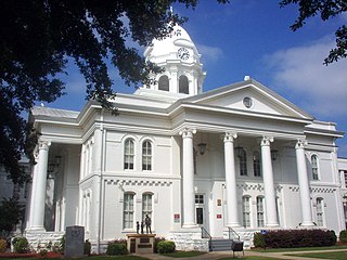
Centre is a city in Cherokee County, Alabama, United States. At the 2020 census, the population was 3,587. The city is the county seat of Cherokee County.

Baileyton is a town in Cullman County, Alabama, United States. At the 2020 census, the population was 649.

Ariton is a town in Dale County, Alabama, United States. At the 2020 census, the population was 662. It was incorporated in April 1906. The name is a blend of its two predecessor town names: Ariosto and Charlton.

Ider is a town in DeKalb County, Alabama, United States. At the 2020 census, the population was 735. It incorporated in October 1973.

Powell is a town in DeKalb County, Alabama, United States. At the 2020 census, the population was 901. Powell is located atop Sand Mountain.

East Brewton is a city in Escambia County, Alabama, United States. It was incorporated in October 1918. At the 2020 census, the population was 2,293. The community grew around Fort Crawford, a fort built to protect early settlers of the area.

Paint Rock is a town in Jackson County, Alabama, United States, along the Paint Rock River, and is included in the Huntsville-Decatur Combined Statistical Area. It was incorporated in July 1894.

Courtland is a town in Lawrence County, Alabama, United States, and is included in the Decatur Metropolitan Area, as well as the Huntsville-Decatur Combined Statistical Area. The population was 609 at the 2010 census, down from 769 in 2000.

Ardmore is a town in Limestone County, Alabama, United States, and is included in the Huntsville-Decatur Metro Area. The population was 1,321 at the 2020 census, It borders its sister city Ardmore, Tennessee.

Wilsonville is a town in southeastern Shelby County, Alabama, United States, located northeast of Columbiana. At the 2020 census, the population was 1,857. Wilsonville is named after the earliest settler in the area, Elisha Wilson.
Berlin is a town in Cullman County, Alabama, United States. The population was 476 at the 2020 census. It is located roughly five miles east of the city of Cullman in northern Alabama. U.S. Route 278 and Cullman County Road 747 intersect at Walker's Corner, considered to be the center of Berlin. The Berlin Community Center is located on U.S. Route 278, just west of the crossroads.


