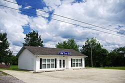
Hytop, Alabama | |
---|---|
Coordinates: 34°54′17″N86°5′12″W / 34.90472°N 86.08667°W | |
Country | United States |
State | Alabama |
County | Jackson |
Area | |
• Total | 3.46 sq mi (8.97 km2) |
• Land | 3.46 sq mi (8.96 km2) |
• Water | 0.00 sq mi (0.01 km2) |
Elevation | 1,709 ft (521 m) |
Population (2020) | |
• Total | 441 |
• Density | 127.46/sq mi (49.21/km2) |
Time zone | UTC-6 (Central (CST)) |
• Summer (DST) | UTC-5 (CDT) |
ZIP code | 35768 |
Area code | 256 |
FIPS code | 01-37264 |
GNIS feature ID | 0156510 |
Website | https://townofhytop.com/ |
Hytop is a town in Jackson County, Alabama, United States. It incorporated on May 17, 1991. [2] As of the 2010 census, the population of the town was 354, up from 315 in 2000. The Walls of Jericho, a popular hiking area, is located just north of Hytop.
Hytop is located at 34°54′17″N86°5′12″W / 34.90472°N 86.08667°W (34.904816, -86.086634). [3] The town is situated atop the Cumberland Plateau just south of the Alabama-Tennessee state line. State Route 79 traverses Hytop, connecting the town with Skyline to the south, and Tennessee to the north. The highway becomes Tennessee State Route 16 at the border, and continues northward to Winchester, Tennessee. A narrow valley carved by Hurricane Creek (a tributary of the Paint Rock River) is located just west of Hytop, and The Walls of Jericho lie near the head of this valley at the state line.
According to the U.S. Census Bureau, the town has a total area of 2.3 square miles (6.0 km2), all land.
Census | Pop. | Note | %± |
---|---|---|---|
2000 | 315 | — | |
2010 | 354 | 12.4% | |
2020 | 441 | 24.6% | |
U.S. Decennial Census [4] 2013 Estimate [5] |
As of the census [6] of 2000, there were 315 people, 124 households, and 108 families residing in the town. The population density was 139.5 inhabitants per square mile (53.9/km2). There were 139 housing units at an average density of 61.5 per square mile (23.7/km2). The racial makeup of the town was 96.19% White, 1.27% Native American, and 2.54% from two or more races. 0.32% of the population were Hispanic or Latino of any race.
There were 124 households, out of which 37.9% had children under the age of 18 living with them, 76.6% were married couples living together, 7.3% had a female householder with no husband present, and 12.1% were non-families. 10.5% of all households were made up of individuals, and 4.8% had someone living alone who was 65 years of age or older. The average household size was 2.54 and the average family size was 2.72.
In the town, the population was spread out, with 23.8% under the age of 18, 9.2% from 18 to 24, 34.9% from 25 to 44, 24.4% from 45 to 64, and 7.6% who were 65 years of age or older. The median age was 35 years. For every 100 females, there were 99.4 males. For every 100 females age 18 and over, there were 90.5 males.
The median income for a household in the town was $34,306, and the median income for a family was $34,821. Males had a median income of $29,107 versus $19,286 for females. The per capita income for the town was $15,093. None of the families and none of the population were living below the poverty line.
The National Weather Service has a radar site in Hytop. It was damaged during the 2011 Super Outbreak, but later replaced.
Morgan County is a county in the north-central part of the U.S. state of Alabama. As of the 2020 census, its population was 123,421. The county seat is Decatur. On June 14, 1821, it was renamed in honor of American Revolutionary War General Daniel Morgan of Virginia. It is a prohibition or dry county, although alcohol sales are allowed in the cities of Decatur, Hartselle, and Priceville. Morgan County is included in the Decatur, AL Metropolitan Statistical Area, which is also included in the Huntsville-Decatur-Albertville, AL Combined Statistical Area. It is a part of the North, Northwest, and North-Central regions of Alabama.
Altoona is a town in Etowah County in the U.S. state of Alabama. It is part of the Gadsden Metropolitan Statistical Area. At the 2020 census, the population was 948.
Fairview is a town in Cullman County, Alabama, United States. At the 2010 census the population was 446, down from 522 in 2000. It incorporated in 1968.
West Point is a town in Cullman County, Alabama, United States. The population was 584 at the 2020 census. West Point was incorporated on October 15, 1977.
Geraldine is a town in DeKalb County, Alabama, United States. It was incorporated in February 1957. At the 2020 census, the population was 910.
Sylvania is a town in DeKalb County, Alabama, United States. It incorporated in October 1967. At the 2010 census the population was 1,837, up from 1,186 in 2000. Sylvania is located atop Sand Mountain. Sylvania was incorporated in 1967. The post office /town hall was built in 1977.
Deatsville is a town in Elmore County, Alabama, United States. Although Deatsville initially incorporated in 1903, it lapsed at some point after the 1910 U.S. Census and did not appear again as incorporated until 2000. As of the 2020 census, the population was 1,679.
Sardis City is a town in Etowah and Marshall counties in the U.S. state of Alabama. It is part of the Gadsden Metropolitan Statistical Area. It originally incorporated in May 1963 under the name of "Sardis". It became Sardis City in the 1980s. At the 2020 census, the population was 1,814.
Paint Rock is a town in Jackson County, Alabama, United States, along the Paint Rock River, and is included in the Huntsville-Decatur Combined Statistical Area. It was incorporated in July 1894.
Skyline is a town in Jackson County, Alabama, United States. The town incorporated in 1985. As of the 2010 census, the population of the town was 851, up from 843 in 2000.
Woodville is a town in Jackson County, Alabama, United States. It was officially established by an act of the Alabama State Legislature on December 13, 1819, one day before Alabama became a state. It was later incorporated on May 12, 1890, but lost its charter in 1897. It reincorporated in 1912. As of the 2010 census, the population of the town is 746, down from 761 in 2000.
Fort Deposit is a town in Lowndes County, Alabama, United States. Since 1890, it has been the largest town in Lowndes County. At the 2010 census the population was 1,344, up from 1,270 in 2000. It is part of the Montgomery Metropolitan Statistical Area.
Mosses is a town in Lowndes County, Alabama, United States. At the 2010 census the population was 1,029, down from 1,101 in 2000. It is part of the Montgomery Metropolitan Statistical Area. It incorporated in 1979.
Owens Cross Roads is a town in Madison County, Alabama, United States, and is included in the Huntsville-Decatur Combined Statistical Area. It was incorporated on October 9, 1967. The population was 2,594 at the 2020 census. It is home to Brazelton Cemetery.
Union Grove is a town in Marshall County, Alabama, United States, and is included in the Huntsville-Decatur Combined Statistical Area. As of the 2020 census, the population of the town was 67, down from 77 at the 2010 census.
Priceville is the third largest municipality in Morgan County, Alabama, United States and is included in the Decatur Metropolitan Area, as well as the Huntsville-Decatur Combined Statistical Area. The 2020 census counted a population of 3,513, up from 2,658 in 2010.
Somerville is a town in Morgan County, Alabama, United States. It is included in the Decatur Metropolitan Area and the Huntsville-Decatur Combined Statistical Area. As of the 2020 census, the population of the town was 796.
Springville is a city in St. Clair County, Alabama, United States. It incorporated in December 1880. At the 2020 census the population was 4,786, up from 4,080 in 2010.
Centerville is an unincorporated community and census-designated place (CDP) in Klickitat County, Washington, United States. Settled in 1877 by Albert J. Brown, the population was 94 at the 2020 census.
Ardmore is a city in Giles and Lincoln counties, Tennessee, United States. The population was 1,217 at the 2020 census. Ardmore is the site of a Tennessee Department of Tourist Development Welcome Center. It borders its sister city, Ardmore, Alabama.