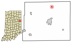
Bryant, Indiana | |
---|---|
Town of Bryant | |
Coordinates: 40°32′09″N84°57′48″W / 40.53583°N 84.96333°W | |
Country | United States |
State | Indiana |
County | Jay |
Township | Bearcreek |
Area | |
• Total | 0.32 sq mi (0.83 km2) |
• Land | 0.32 sq mi (0.83 km2) |
• Water | 0.00 sq mi (0.00 km2) |
Elevation | 873 ft (266 m) |
Population (2020) | |
• Total | 239 |
• Density | 749.22/sq mi (289.60/km2) |
Time zone | UTC-5 (EST) |
• Summer (DST) | UTC-5 (EST) |
ZIP code | 47326 |
Area code | 260 |
FIPS code | 18-08704 [3] |
GNIS feature ID | 2396615 [2] |
Bryant is a town in Bearcreek Township, Jay County, Indiana, United States. The population was 252 at the 2010 census.
Bryant had its start in the early 1870s by the building of the railroad through that territory. Its name is derived from that of an Irishman named Bryan, who was instrumental in bringing the railroad there. [4] The Bryant post office was established in 1872. [5] Bryant was incorporated as a town in 1897. [6]
According to the 2010 census, the town has a total area of 0.30 square miles (0.78 km2), all land. [7]
Census | Pop. | Note | %± |
---|---|---|---|
1880 | 189 | — | |
1900 | 384 | — | |
1910 | 469 | 22.1% | |
1920 | 428 | −8.7% | |
1930 | 319 | −25.5% | |
1940 | 332 | 4.1% | |
1950 | 339 | 2.1% | |
1960 | 316 | −6.8% | |
1970 | 320 | 1.3% | |
1980 | 277 | −13.4% | |
1990 | 273 | −1.4% | |
2000 | 272 | −0.4% | |
2010 | 252 | −7.4% | |
2020 | 239 | −5.2% | |
U.S. Decennial Census [8] |
As of the census [9] of 2010, there were 252 people, 99 households, and 68 families living in the town. The population density was 840.0 inhabitants per square mile (324.3/km2). There were 116 housing units at an average density of 386.7 per square mile (149.3/km2). The racial makeup of the town was 97.2% White, 0.4% African American, 0.8% Native American, 0.8% Asian, and 0.8% from two or more races. Hispanic or Latino of any race were 2.4% of the population.
There were 99 households, of which 32.3% had children under the age of 18 living with them, 48.5% were married couples living together, 9.1% had a female householder with no husband present, 11.1% had a male householder with no wife present, and 31.3% were non-families. 28.3% of all households were made up of individuals, and 9.1% had someone living alone who was 65 years of age or older. The average household size was 2.55 and the average family size was 3.07.
The median age in the town was 38.5 years. 24.2% of residents were under the age of 18; 9.4% were between the ages of 18 and 24; 22.6% were from 25 to 44; 29.3% were from 45 to 64; and 14.3% were 65 years of age or older. The gender makeup of the town was 49.2% male and 50.8% female.
As of the census [3] of 2000, there were 272 people, 95 households, and 74 families living in the town. The population density was 897.9 inhabitants per square mile (346.7/km2). There were 109 housing units at an average density of 359.8 per square mile (138.9/km2). The racial makeup of the town was 97.79% White, 0.37% Asian, 0.37% from other races, and 1.47% from two or more races. Hispanic or Latino of any race were 1.10% of the population.
There were 95 households, out of which 35.8% had children under the age of 18 living with them, 64.2% were married couples living together, 6.3% had a female householder with no husband present, and 22.1% were non-families. 18.9% of all households were made up of individuals, and 7.4% had someone living alone who was 65 years of age or older. The average household size was 2.86 and the average family size was 3.27.
In the town, the population was spread out, with 30.9% under the age of 18, 7.7% from 18 to 24, 32.7% from 25 to 44, 18.8% from 45 to 64, and 9.9% who were 65 years of age or older. The median age was 32 years. For every 100 females there were 121.1 males. For every 100 females age 18 and over, there were 106.6 males.
The median income for a household in the town was $34,821, and the median income for a family was $41,042. Males had a median income of $21,833 versus $17,266 for females. The per capita income for the town was $13,416. None of the families and 4.4% of the population were living below the poverty line.
Dunkirk is a city in Blackford and Jay counties in the U.S. state of Indiana. The population was 2,164 at the 2020 census.
Milltown is a town in Blue River and Spencer townships in Harrison County and Whiskey Run Township in Crawford County, Indiana. The population was 818 at the time of the 2010 census.
Ashley is a town in Indiana located on the border of Smithfield Township, DeKalb County and Steuben Township, Steuben County. The population was 983 at the 2010 census.
Albany is a town in Delaware and Randolph counties in the U.S. state of Indiana, along the Mississinewa River. The population was 2,295 at the 2020 census. It is part of the Muncie, IN Metropolitan Statistical Area.
Andrews is a town in Dallas Township, Huntington County, Indiana, United States. The population was 1,048 at the 2020 census.
Redkey is a town in Richland Township, Jay County, Indiana, United States. The population was 1,353 at the 2010 census.
Salamonia is a town in Madison Township, Jay County, Indiana, United States. The population was 157 at the 2010 census. The town is situated along the Salamonie River, near its headwaters in Northern Indiana.
Etna Green is a town in Etna Township, Kosciusko County, in the U.S. state of Indiana. The population was 586 at the 2010 census.
Sidney is a town in Jackson Township, Kosciusko County, in the U.S. state of Indiana. The population was 83 at the 2010 census.
Silver Lake is a town in Lake Township, Kosciusko County, in the U.S. state of Indiana. The population was 915 at the 2010 census.
River Forest is a town in Anderson Township, Madison County, Indiana, United States. It is part of the Indianapolis–Carmel–Anderson metropolitan statistical area. The population was 26 at the 2020 census. Making it the second smallest to in Indiana no, it was the smallest town in Indiana in 2010, when it had 22, but the population had risen to 26. New Amsterdam is now the smallest town in Indiana with the population of just 12.
Summitville is a town in Van Buren Township, Madison County, Indiana, United States. It is part of the Indianapolis–Carmel–Anderson metropolitan statistical area. The population was 989 at the 2020 census.
Bethany is a town in Clay Township, Morgan County, in the U.S. state of Indiana. The population was 95 at the 2020 census.
Modoc is a town in Union Township, Randolph County, in the U.S. state of Indiana. The population was 196 at the 2010 census.
Clear Lake is a town located in the northeast corner of Steuben County, Indiana, in Clear Lake Township. As such, is the northeasternmost community in the State of Indiana. The population was 339 at the 2010 census.
Hudson is a town in Salem and Steuben townships, Steuben County, in the U.S. state of Indiana. The population was 518 at the 2010 census.
Liberty is a town in and the county seat of Union County, Indiana, United States, located about 5 miles (8.0 km) west of the state's border with Ohio. The population was 2,000 at the 2020 census.
Woodstock is a town in Oxford County, Maine, United States. The population was 1,352 at the 2020 census. The village of Bryant Pond, on State Route 26 in the northern part of Woodstock, is the town's urban center and largest settlement.
Spring Hill is a town in Marion County, Indiana, United States. The population was 95 at the 2020 census. It has existed as an "included town" since 1970, when it was incorporated into Indianapolis as part of Unigov. It is part of Indianapolis, but retains town governmental powers under IC 36-3-1-11.
Wynnedale is a town in Washington Township, Marion County, Indiana, United States. The population was 215 at the 2020 census. It has existed as an "included town" since 1970, when it was incorporated into Indianapolis as part of Unigov. It is part of Indianapolis, but retains a functioning town government under IC 36-3-1-11.