Burdett, New York

Last updated

Burdett, New York
USA New York location map.svg
Red pog.svg
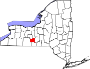
Burdett, New York
Location within the state of New York
Coordinates: 42°24′57″N76°50′57″W / 42.41583°N 76.84917°W / 42.41583; -76.84917
Country United States
State New York
County Schuyler
Area
[1]
  Total0.96 sq mi (2.49 km2)
  Land0.96 sq mi (2.49 km2)
  Water0.00 sq mi (0.00 km2)
Elevation
978 ft (298 m)
Population
 (2020)
  Total331
  Density344.07/sq mi (132.86/km2)
Time zone UTC-5 (Eastern (EST))
  Summer (DST) UTC-4 (EDT)
ZIP code
14818
Area code 607
FIPS code 36-11132
GNIS feature ID0973990

Burdett is a village in Schuyler County, New York, United States. The population was 357 at the 2000 census.

Contents

The Village of Burdett is within the Town of Hector, east of Seneca Lake and northeast of Watkins Glen.

History

The village is the site of the first settlement in the Town of Hector, circa 1790.

Geography

Burdett is located at 42°24′57″N76°50′57″W / 42.41583°N 76.84917°W / 42.41583; -76.84917 (42.415960, -76.849250). [2]

According to the United States Census Bureau, the village has a total area of 1.0 square mile (2.6 km2), all land.

New York State Route 79 and Logan Creek pass through the village. Burdett is in the Finger Lakes District.

The Finger Lakes Trail, a 584-mile footpath that travels from western to eastern New York State and the through the southern Finger Lakes region of New York State also goes through the Burdett village center, entering from the west, into the village center, then heading north toward the Finger Lakes National Forest.

Demographics

Historical population
CensusPop.Note
1860 360
1900 409
1910 382−6.6%
1920 380−0.5%
1930 310−18.4%
1940 40831.6%
1950 4325.9%
1960 420−2.8%
1970 4548.1%
1980 410−9.7%
1990 372−9.3%
2000 357−4.0%
2010 340−4.8%
2020 331−2.6%
U.S. Decennial Census [3]

As of the census [4] of 2000, there were 357 people, 147 households, and 97 families residing in the village. The population density was 369.5 inhabitants per square mile (142.7/km2). There were 171 housing units at an average density of 177.0 per square mile (68.3/km2). The racial makeup of the village was 99.16% White, and 0.56% Native American. 0.28% African American, Hispanic or Latino of any race were 0.28% of the population.

There were 147 households, out of which 27.2% had children under the age of 18 living with them, 49.0% were married couples living together, 10.9% had a female householder with no husband present, and 34.0% were non-families. 27.2% of all households were made up of individuals, and 11.6% had someone living alone who was 65 years of age or older. The average household size was 2.43 and the average family size was 2.86.

In the village, the population was spread out, with 23.8% under the age of 18, 6.4% from 18 to 24, 30.0% from 25 to 44, 26.3% from 45 to 64, and 13.4% who were 65 years of age or older. The median age was 38 years. For every 100 females, there were 87.9 males. For every 100 females age 18 and over, there were 85.0 males.

The median income for a household in the village was $36,023, and the median income for a family was $40,250. Males had a median income of $30,192 versus $22,031 for females. The per capita income for the village was $16,588. About 4.7% of families and 8.2% of the population were below the poverty line, including 5.9% of those under age 18 and 7.7% of those age 65 or over.

Related Research Articles

<span class="mw-page-title-main">Fort Pierce South, Florida</span> CDP in Florida, United States

Fort Pierce South is a census-designated place (CDP) in St. Lucie County, Florida, United States. The population was 5,062 at the 2010 census. It is part of the Port St. Lucie Metropolitan Statistical Area.

<span class="mw-page-title-main">Deer Park, Illinois</span> Village in Illinois, United States

Deer Park is a village in Lake and Cook Counties, Illinois. Per the 2020 census, the population was 3,681. The village is one of the few left in the Chicago area that enjoy a green belt which is bordered by two large natural areas providing outdoor recreation and open space. The village is home to popular shopping and dining destinations: Deer Park Town Center and the Town Center Promenade. The town is also home to the Vehe Farm, an Illinois Centennial Farm.

<span class="mw-page-title-main">Tuscarora Township, Michigan</span> Civil township in Michigan, United States

Tuscarora Township is a civil township of Cheboygan County in the U.S. state of Michigan. The population was 3,038 at the 2010 census.

<span class="mw-page-title-main">Fleming, New York</span> Town in New York, United States

Fleming is a town in Cayuga County, New York, United States. The population was 2,475 at the 2020 census. The name is that of General George Fleming, an early settler. Fleming is at the northern end of Owasco Lake, south of Auburn.

<span class="mw-page-title-main">Ledyard, New York</span> Town in New York, United States

Ledyard is a town in Cayuga County, New York, United States. The population was 1,654 at the 2020 census. The name of the town is from General Benjamin Ledyard, an early settler of the town. Ledyard is on the western edge of the county and is southwest of Auburn.

<span class="mw-page-title-main">Locke, New York</span> Town in New York, United States

Locke is a town in Cayuga County, New York, United States. The population was 1,877 at the 2020 census. The town was named after John Locke, an English philosopher, and is the birthplace of Millard Fillmore, 13th President of the United States.

<span class="mw-page-title-main">Niles, New York</span> Town in New York, United States

Niles is a town in Cayuga County, New York, United States. The population was 1,194 at the 2010 census. Niles lies in the eastern part of the county, southeast of Auburn.

<span class="mw-page-title-main">Union Springs, New York</span> Village in New York, United States

Union Springs is a village in Cayuga County, New York, United States. The population was 1,197 at the 2010 census. The name is derived from the mineral springs near the village. Union Springs is in the western part of the town of Springport and is southwest of Auburn.

Celoron is a village in Chautauqua County, New York, United States. It is part of the town of Ellicott and sits on the west boundary of the city of Jamestown. The population of Celoron was 1,082 at the 2020 census.

<span class="mw-page-title-main">Preble, New York</span> Town in New York, United States

Preble is a town in Cortland County, New York, United States. The population was 1,393 at the 2010 census. The town is named after Commodore Edward Preble, a naval hero.

<span class="mw-page-title-main">Angola on the Lake, New York</span> Census-designated place in New York, United States

Angola on the Lake is a hamlet and census-designated place (CDP) in Erie County, New York, United States. The population was 1,675 at the 2010 census. It is part of the Buffalo–Niagara Falls Metropolitan Statistical Area.

Hector is a town in the northeastern corner of Schuyler County, New York, United States. The population was 4,916 at the 2020 census. The town is named after Hector Ely, who at the time was the firstborn son of the town founders. Hector is west of Ithaca.

Pulteney is a town in Steuben County, New York, United States. The population was 1,260 at the 2020 census. The name is derived from the name of the original pioneer tract of land.

<span class="mw-page-title-main">Dresden, Yates County, New York</span> Village in New York, United States

Dresden is a village in Yates County, New York, United States. The population was 308 at the 2010 census. The village was named after Dresden in Germany.

<span class="mw-page-title-main">Dundee, New York</span> Village in New York, United States

Dundee is a village in Yates County, New York, United States. The population was 1,725 at the 2010 census. The name was taken from Dundee, the city in Scotland with a population of 148,260.

<span class="mw-page-title-main">Salunga-Landisville, Pennsylvania</span> CDP in Pennsylvania, United States

Salunga-Landisville consists of two census-designated places (CDPs) in Lancaster County, Pennsylvania, United States with a zip code of 17538. As of the 2010 United States Census the population of Salunga CDP was 2,695 people and the population of Landisville CDP was 1,893 people for a combined total of 4,588, a decrease of about 3.8% from the 2000 United States Census which recorded 4,771 in the Salunga-Landisville CDP. The name "Salunga" comes from the nearby Chiquesalunga Creek, which in turn is derived from the Lenape "Chiquesalunga", meaning "place of the crayfish". Landisville is named for John Landis, the first postmaster there.

Lodi is a village in Seneca County, New York, United States. The population was 291 at the 2010 census.

Ovid is a village in Seneca County, New York, United States. The population was 602 at the 2010 census. The town was named by a clerk interested in the classics.

Rosendale is a town in Fond du Lac County, Wisconsin, United States. The population was 783 at the 2000 census. The village of Rosendale is located partially within the town. The unincorporated communities of Rosendale Center and West Rosendale are also located in the town.

<span class="mw-page-title-main">Tower Lakes, Illinois</span> Village in Illinois, United States

Tower Lakes is a village in Lake County, Illinois, United States. Per the 2020 census, the population was 1,226.

References

  1. "ArcGIS REST Services Directory". United States Census Bureau. Retrieved September 20, 2022.
  2. "US Gazetteer files: 2010, 2000, and 1990". United States Census Bureau. February 12, 2011. Retrieved April 23, 2011.
  3. "Census of Population and Housing". Census.gov. Retrieved June 4, 2015.
  4. "U.S. Census website". United States Census Bureau . Retrieved January 31, 2008.