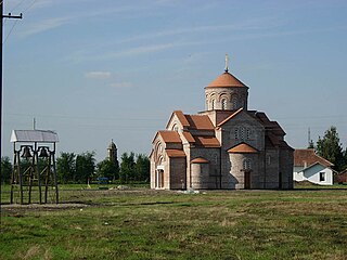
Plandište is a village and municipality located in the South Banat District of the autonomous province of Vojvodina, Serbia. The village has a population of 3,832, while Plandište municipality has 11,336 inhabitants. One of municipality's best known landmarks is Kapetanovo Castle, located in Stari Lec.
Ura is a village in Szabolcs-Szatmár-Bereg County in the Northern Great Plain region of eastern Hungary. Small Hungarian village near the Hungarian-Ukrainian border.
Tiszakanyár is a village in Szabolcs-Szatmár-Bereg county, in the Northern Great Plain region of eastern Hungary.

Timár is a village in Szabolcs-Szatmár-Bereg county, in the Northern Great Plain region of eastern Hungary.

Vatta is a village in Borsod-Abaúj-Zemplén County, Hungary. It lies in the south of the county, 30 km (20 mi) from Miskolc and 19 km (12 mi) from Mezőkövesd.
Kercseliget is a village in Somogy County, southern Hungary.

Kisasszond is a village in Somogy county, Hungary.
Kéthely is a village in Somogy County, Hungary.

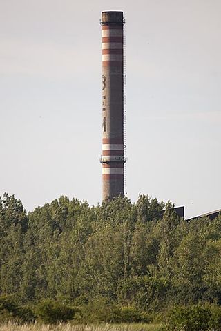
Tapsony is a village in Somogy county, Hungary. It has a village hall for social events held throughout the year. There is a playing field where the football team of Tapsony play its home matches. It has good bus links with Bohonye and Marcali. The Pausch factory provides local employment and beams out an internet signal, which you can subscribe to through an internet company. The village is surrounded by rolling countryside which is mainly for agricultural use, in the summer some fields are planted with maize and sunflowers. Temperatures in the summer can reach the high 30s, winter temperatures can be as low as minus 20.

Lábod is a village in Somogy county, Hungary.

The village of Újcsanálos is located in the county of Borsod-Abaúj-Zemplén, in the Miskolc district, in the valley of the Hernád river, the same distance from Miskolc and Szerencs, which is part of the historic Zemplén county, including the Harangod region.
Sajókeresztúr is a village in Borsod-Abaúj-Zemplén County in northeastern Hungary, about seven kilometres north of Miskolc, between Szirmabesenyő and Sajóecseg. It has a kindergarten, a primary school and a football team.

Péter Máté is a Hungarian midfielder who currently plays for Zalaegerszegi TE.

Parádsasvár is a village in Heves County, Hungary, in the Mátra mountain range, the bottom of the eastern side of the Galya-tető peak, the Parádi-Tarna creek flows through the settlement. As of 2022 census, it has a population of 335. The village located 10.7 km from Kisterenye–Kál-Kápolna railway line, 25.6 km from the main road 3 and 32.2 km from the M3 motorway. Although the Recsk-Parádfürdő railway station is the closest, but public transport on the railway line ceased on 3 March 2007. The closest train station with public transport in Bátonyterenye 22.7 km far.

Mátramindszent is a village in Nógrád County, Hungary, in the Mátra mountain range, the bottom of the north side of the Galya-tető peak, the Mindszenti creek flows through the settlement. As of 2022 census, it has a population of 707. The village is located 2.0 km from Kisterenye–Kál-Kápolna railway line, 11.7 km from the main road 21 and 52.1 km from the M25 expressway. Although the settlement has its own railway station, but public transport on the railway line ceased on 3 March 2007. The closest train station with public transport in Bátonyterenye 11.7 km far.
Mátraszele is a village in Nógrád County, Hungary, the Zagyva river flows through the settlement. As of 2022 census, it has a population of 904. The village located 8.5 km from Hatvan–Fiľakovo railway line, 12.0 km far from Salgótarján, 10.4 km from the main road 21 and 52.8 km from the M3 motorway. The closest train station with public transport in Bátonyterenye 10.4 km far.

Mátraszőlős is a village in Nógrád County, Hungary, under the Cserhát mountain ranges, beside of the Hévíz creek. As of 2022 census, it has a population of 1454. The village located beside of the main road 21 and 3.0 km far from the Hatvan–Fiľakovo railway line and 32.7 km from the M3 motorway. The settlement has an own railway stop with public transport under the name Mátraszőlős-Hasznos.

Mátraterenye is a village in Nógrád County, Hungary, the Zagyva river flows through the settlement. As of 2022 census, it has a population of 1661. The village located 7.1 km from Kisterenye–Kál-Kápolna railway line, 14.8 km from the main road 21 and 47.1 km from the M25 expressway. Although the Nemti railway stop is the closest, but public transport on the railway line ceased on 3 March 2007. The closest train station with public transport in Bátonyterenye 13.7 km far.

The Balatonboglár wine region, also known as the South Balaton wine region, is the only one wine region in Somogy County, Hungary. The area consists of 37 settlements, mainly located on the southern shore of Lake Balaton, but also some near Kaposvár like Böhönye, Csurgó and Nagyberki. It is part of the greater Balaton wine region.
Zagyvaszántó is a village in Heves County, Hungary, beside of the Zagyva river. As of 2022 census, it has a population of 1825. The village located beside of the Hatvan–Fiľakovo railway line and the main road 21 and 12.0 km away from the M3 motorway. The village have an own railway station under the name of Apc-Zagyvaszántó with public transport.


