Camp H. M. Smith

Last updated
Camp H. M. Smith
Seal of MARFORPAC (2001).gif
CMC and SMMC visit MARFORPAC 150319-M-WQ429-063.jpg
Coordinates 21°23′09″N157°54′23″W / 21.38583°N 157.90639°W / 21.38583; -157.90639
Area220 acres (0.89 km2)
Site information
Owner United States Department of Defense
Garrison information
Garrison

Camp H. M. Smith is a United States Marine Corps installation in the Halawa census-designated place on the island of Oahu, Hawaii, [1] near the community of Halawa (ha-LA-va) Heights. It is the headquarters of the United States Indo-Pacific Command (INDOPACOM), Special Operations Command Pacific, and Marine Forces Pacific, the Marine service component command of INDOPACOM.

Contents

The camp, originally the Aiea Naval Hospital, was named for General Holland McTyeire Smith, the first commanding general of Fleet Marine Force Pacific, on June 8, 1955. The initials H. M. also stood for his nickname which was "Howling Mad" referring to his temper and given to him by his Marines.

History

IBM 729 computer tape drive, circa 1969 Camp Smith, Hawaii. PFC Patricia Barbeau operates a tape-drive on the IBM 729 at Camp Smith. - NARA - 532417.jpg
IBM 729 computer tape drive, circa 1969
Lyndon B. Johnson and others at the Declaration of Honolulu at Camp Smith, February 8, 1966. Honolulu Conference on the Vietnam War - A1916-26a.jpg
Lyndon B. Johnson and others at the Declaration of Honolulu at Camp Smith, February 8, 1966.

An Act of Congress on 17 March 1941 had approved purchase of the site, then a sugar cane field, for a Navy Hospital. In 1941, the investment for the 220½ acres of Camp Smith land, in fee simple (a term for owning both the land and the buildings), was $912,000, and improvements cost an additional $14 million. Work commenced in July and progressed slowly. Following the attack on Pearl Harbor on December 7, construction of the planned 1,650-bed facility was rushed to completion. With Admiral Chester W. Nimitz in attendance, the hospital was commissioned on November 11, 1942, but continued expansion was necessary.

Throughout World War II, the Aiea Naval Hospital served as a stopping off place for thousands of wounded sailors and Marines on their way home from the war in the Pacific. Hospital activity peaked following the battle for Iwo Jima in February and March, 1945, when 5,676 patients received medical care simultaneously.

On June 1, 1949, the hospital was deactivated and Army and Navy medical facilities were consolidated at what is now the Tripler Army Medical Center. In 1950, the Territory of Hawaii began negotiations to obtain the Aiea facility for a tuberculosis sanitarium.

In 1955, however, the Marine Corps selected the site as the home of the Fleet Marine Force Pacific. The first Marines took up residence in October 1955; the headquarters staff placed the camp in full operation just two weeks before its dedication on January 31, 1956.

In October 1957, Camp Smith also became the headquarters for the Commander in Chief, U.S. Pacific Command, who formerly shared the headquarters of the Commander in Chief, U.S. Pacific Fleet at Makalapa, near Pearl Harbor. Both commands were headed by the same officer until 13 January 1958, when a separate officer was named to serve as Commander in Chief, Pacific Fleet. In July 1992, FMFPac was further designated as the component command, Marine Forces Pacific. In April 1994, Marine Corps Base Hawaii assumed operational responsibility for Camp H. M. Smith.

Camp Smith today consists of 220 acres (0.89 km2) at Camp Smith proper, 137 acres (0.55 km2) at Puuloa Rifle Range in Ewa Beach, and 62 acres (250,000 m2) in Manana Housing. Camp Smith is unique in that it is the only Marine Corps installation that supports a unified commander, Commander, Indo-Pacific Command (CDRUSINDOPACOM). [2]

Related Research Articles

<span class="mw-page-title-main">Aiea, Hawaii</span> Census-designated place in Hawaii, United States

ʻAiea is a census-designated place (CDP) located in the City and County of Honolulu, Hawaii, United States. As of the 2010 Census, the CDP had a total population of 9,338.

<span class="mw-page-title-main">Halawa, Hawaii</span> Census-designated place in Hawaii, United States

Halawa is a census-designated place (CDP) in the ‘Ewa District of Honolulu County, Hawaii, United States. Halawa Stream branches into two valleys: North and South Halawa; North Halawa is the larger stream and fluvial feature. Their confluence is within the H-3/H-201 highways exchange. Most of Halawa Valley is undeveloped. As of the 2020 census, the CDP had a population of 15,016.

<span class="mw-page-title-main">Marine Corps Base Hawaii</span> US Marine Corps base near Honolulu, Oahu, Hawaii, United States

Marine Corps Base Hawaii (MCBH), formerly Marine Corps Air Station Kaneohe Bay and originally Naval Air Station Kaneohe Bay, is a U.S. Marine Corps facility and air station located on the Mokapu Peninsula of windward O'ahu in the City & County of Honolulu. Marine Corps Base Hawaii is home to Marines, Sailors, their family members, and civilian employees. The United States Marine Corps operates a 7,800-foot (2,400 m) runway at the base.

<span class="mw-page-title-main">Pearl City, Hawaii</span> Census-designated place in Hawaii, United States

Pearl City is an unincorporated community and census-designated place (CDP) in the ʻEwa District and City & County of Honolulu on the island of Oʻahu. As of the 2010 census, the CDP had a population of 47,698. Pearl City sits along the north shore of Pearl Harbor. Waimalu borders Pearl City to the east and Waipahu borders the west. The U.S. postal code for Pearl City is 96782.

<span class="mw-page-title-main">Waimalu, Hawaii</span> Census-designated place in Hawaii, United States

Waimalu is a census-designated place (CDP) in Honolulu County, Hawaiʻi, United States. The population was 13,817 at the 2020 census.

<span class="mw-page-title-main">Washington Place</span> United States historic place

Washington Place is a Greek Revival palace in the Hawaii Capital Historic District in Honolulu, Hawaii. It was where Queen Liliʻuokalani was arrested during the overthrow of the Hawaiian Kingdom. Later it became the official residence of the governor of Hawaii. In 2007, it was designated as a National Historic Landmark. The current governor's residence was built in 2008 behind the historic residence, and is located on the same grounds as Washington Place.

<span class="mw-page-title-main">Hawthorne Army Depot</span> Facility of the US Army Joint Munitions Command

Hawthorne Army Depot (HWAD) is a U.S. Army Joint Munitions Command ammunition storage depot located near the town of Hawthorne in western Nevada in the United States. It is directly south of Walker Lake. The depot covers 147,000 acres (59,000 ha) or 226 sq. mi. and has 600,000 square feet (56,000 m2) storage space in 2,427 bunkers. HWAD is the "World's Largest Depot". It is divided into three ammunition storage and production areas, plus an industrial area housing command headquarters, facilities, engineering shops, etc.

<span class="mw-page-title-main">Fort Shafter</span> United States Army Pacific headquarters in Honolulu, Hawaii, USA

Fort Shafter, in Honolulu CDP, City and County of Honolulu, Hawai‘i, is the headquarters of the United States Army Pacific, which commands most Army forces in the Asia-Pacific region with the exception of Korea. Geographically, Fort Shafter extends up the interfluve (ridgeline) between Kalihi and Moanalua valleys, as well as onto the coastal plain at Māpunapuna. A portion of the area is also known as the Palm Circle Historic District; it is listed on the National Register of Historic Places and has been further designated as a U.S. National Historic Landmark. It is also known as Palm Circle or 100 Area.

<span class="mw-page-title-main">Oahu Railway and Land Company</span> United States historic place

The Oahu Railway and Land Company, or OR&L, was a 3 ft narrow gauge common carrier railway that served much of the Hawaiian island of Oahu, and was the largest narrow gauge class one common carrier in the U.S, until its dissolution in 1947.

<span class="mw-page-title-main">Lualualei, Hawaii</span> Valley on Oahu in Hawaii, United States

Lualualei, Hawaii is the largest coastal valley on the leeward side of Oʻahu in Hawaiʻi. It is located on the west side of the Waianae Range.

<span class="mw-page-title-main">Marine Corps Air Station Kaneohe Bay</span> US Marine Corps base in Hawaii, United States

Marine Corps Air Station Kaneohe Bay or MCAS Kaneohe Bay is a United States Marine Corps (USMC) airfield located within the Marine Corps Base Hawaii complex, formerly known as Marine Corps Air Facility (MCAF) Kaneohe Bay or Naval Air Station (NAS) Kaneohe Bay. It is located two miles northeast of the central business district of Kaneohe, in Honolulu County, Hawaii, United States. The airfield has one runway (4/22) with a 7,771 x 200 ft asphalt surface.

<span class="mw-page-title-main">Zion Lodge Historic District</span> Historic district in Utah, United States

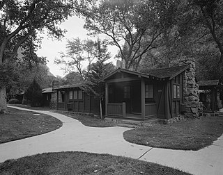
The Zion Lodge Historic District surrounds the rustic lodge originally designed by Gilbert Stanley Underwood in Zion National Park. The lodge served as the center of a group of cabins, employee dormitories and support buildings which are included in the district. A swimming pool and bathhouse were demolished in 1976. The district was expanded in 1986 to include an Underwood-designed former photography studio and additional cabins.

<span class="mw-page-title-main">Fort Kamehameha</span> United States historic place

Fort Kamehameha was a United States Army military base that was the site of several coastal artillery batteries to defend Pearl Harbor starting in 1907 in Honolulu, Hawaii.

<span class="mw-page-title-main">Joint Base Pearl Harbor–Hickam</span> US military joint service installation in Oahu, Hawaii, US

Joint Base Pearl Harbor–Hickam (JBPHH) is a United States military base on the island of Oahu, Hawaii. It is an amalgamation of the United States Air Force's Hickam Air Force Base and the United States Navy's Naval Station Pearl Harbor, which were merged in 2010.

<span class="mw-page-title-main">Naval Square, Philadelphia</span> Neighborhood of Philadelphia in Philadelphia County, Pennsylvania, United States

Naval Square is a gated community within the Graduate Hospital neighborhood of Philadelphia that served as the first United States Naval Academy from 1834 to 1845, when the Naval Academy formed in Annapolis. It continued as a retirement home for sailors and marines and was called the Naval Home until 1976, when the facility was relocated to Mississippi.

<span class="mw-page-title-main">Naval Base Hawaii</span> World War II Bases in Territory of Hawaii

Naval Base Hawaii was a number of United States Navy bases in the Territory of Hawaii during World War II. At the start of the war, much of the Hawaiian Islands was converted from tourism to a United States Armed Forces base. With the loss of US Naval Base Philippines in Philippines campaign of 1941 and 1942, Hawaii became the US Navy's main base for the early part of the island-hopping Pacific War against Empire of Japan. Naval Station Pearl Harbor was founded in 1899 with the annexation of Hawaii.

References

  1. "2020 CENSUS - CENSUS BLOCK MAP: Halawa CDP, HI" (PDF). U.S. Census Bureau . Retrieved 2023-07-01. Cp H M Smith - 2010 map, 2000 map
  2. In symbolic nod to India, U.S. Pacific Command changes name. Retrieved 30 May 2018.