Marine Corps Air Station Kaneohe Bay

Last updated
Marine Corps Air Station Kaneohe Bay
Marion E. Carl Field
Part of Marine Corps Base Hawaii
Near Kaneohe, Hawaii in the United States
US Navy 100924-M-9232S-003 An aerial view of Marine Corps Base Hawaii at Kaneohe Bay.jpg
An aerial view of MCAS Kaneohe Bay during an airshow in 2010.
MCAF Kaneohe Bay logo.jpg
USA Hawaii location map.svg
Red pog.svg
MCAS Kaneohe Bay
Location in Hawaii
Coordinates 21°26′45″N157°46′11″W / 21.44583°N 157.76972°W / 21.44583; -157.76972
TypeMarine Corps Air Station
Site information
Owner Department of Defense
Operator US Marine Corps
Controlled by Marine Corps Installations – Pacific
ConditionOperational
Website www.mcbhawaii.marines.mil
Site history
Built1939 (1939)
In use1939 – 1949 (US Navy)
1952 – present (US Marine Corps)
Garrison information
Current
commander
Lieutenant Colonel Tyler J. Holland
Garrison Marine Aircraft Group 24
Airfield information
Identifiers IATA: NGF, ICAO: PHNG, FAA LID: NGF, WMO: 911760
Elevation7 metres (23 ft) AMSL
Runways
Direction Length and surface
4/222,369 metres (7,772 ft)  Asphalt
Source: Airnav.com [1]
Official nameKaneohe Naval Air Station
Designated28 May 1987
Reference no.87001299 [2]
Period1900–
Area of significanceMilitary

Marine Corps Air Station Kaneohe Bay or MCAS Kaneohe Bay( IATA : NGF, ICAO : PHNG, FAA LID : NGF) is a United States Marine Corps (USMC) airfield located within the Marine Corps Base Hawaii complex, formerly known as Marine Corps Air Facility (MCAF) Kaneohe Bay or Naval Air Station (NAS) Kaneohe Bay. [3] It is located two miles (3 km) northeast of the central business district of Kaneohe, in Honolulu County, Hawaii, United States. The airfield has one runway (4/22) with a 7,771 x 200 ft (2,369 x 61 m) asphalt surface. [4]

Contents

History

Fort Hase and NAS Kaneohe Bay

The United States Army acquired 322 acres (1.30 km2) of the peninsula when President Woodrow Wilson signed executive order 2900 establishing the Kuwaaohe Military Reservation. Little is known about the operations of the fort, however, at the end of World War I, the military property was leased for ranching. In 1939, Kuwaaohe was reactivated, subjected to many name changes to include Camp Ulupa’u, and eventually named Fort Hase.

Prior to and during World War II, Fort Hase grew from a humble beginning as a defense battalion to a major unit of the Windward Coastal Artillery Command. U.S. Navy planners began to eye the peninsula in 1939 as the home of a strategic seaplane base. They liked the isolated location, the flat plains for an airfield and the probability of flights into prevailing trade winds. In 1939, the Navy acquired 464 acres (1.88 km2) of the peninsula for use of the PBY Catalina patrol seaplanes for long-range reconnaissance flights. One year later, the Navy owned all of the Mokapu Peninsula except for Fort Hase. In 1939 the Navy awarded a base construction contract to the Pacific Naval Air Base Contractors consortituim (PNABC). [5] Most of the original contract work at Kaneohe had been completed when the Navy transferred what was undone to the Seabees of the 56th Naval Construction Battalion on 1 April 1943. [5] The 112th CB was tasked with adding a second runway 400' x 5,000' to the airfield. That was completed by the men of the 74th CB. [5]

During the 1941 Attack on Pearl Harbor, portions of Hangar 1 were destroyed. In 1987, the hangar and five sea plane ramps were designated a National Historic Landmark. Hangar 101 MCAS Kaneohe Bay.jpg
During the 1941 Attack on Pearl Harbor, portions of Hangar 1 were destroyed. In 1987, the hangar and five sea plane ramps were designated a National Historic Landmark.

December 7, 1941, the Imperial Japanese Navy attacked the air station minutes prior to the attack on Pearl Harbor. Of the 36 Catalinas stationed here, 27 were destroyed and six others were damaged, along with 18 sailors who perished in the attack. The first Japanese aircraft destroyed in action were shot down at Kaneohe, along with Aviation Ordnanceman Chief Petty Officer John William Finn becoming one of the first Medal of Honor recipients of World War II for valor on that day.

During the war, the air station was a major training base in the Pacific Theater. The Fleet Gunnery School trained thousands of Navy gunners. There was a school for celestial navigation, sonar, aircraft recognition, and turret operations. Flight instructors also trained Navy and Marine Corps aviators in flight operations prior to being sent to a forward combat area. Following the war, Fort Hase had become a skeleton outpost and the air station consisted of limited air operations, a small security detachment, and a federal communications center.

In November 1958 the first of the Pacific Missile Impact Location System for the Navy's Pacific Missile Range (PMR) was operational at the station to monitor Intermediate Range Ballistic Missile (IRBM) test impacts northeast of Hawaii. [6] [7]

Marine Operations

President Richard Nixon shaking hands with Senator Hiram Fong prior to departing for Guam from Kaneohe Marine Corps Air Base on February 20, 1972 Richard Nixon greets Hiram Fong.jpg
President Richard Nixon shaking hands with Senator Hiram Fong prior to departing for Guam from Kaneohe Marine Corps Air Base on February 20, 1972

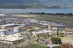
In 1949, the Navy decommissioned the air station. On January 15, 1952, the U.S. Marine Corps recommissioned the idle airfield Marine Corps Air Station Kaneohe Bay, making it an ideal training site for a combined air/ground team. [8] Station Operations and Headquarters Squadron supported flight operations until June 30, 1972, when Station Operations and Maintenance Squadron (SOMS) was commissioned in its place. SOMS served until it was disbanded on July 30, 1994. Marine Corps Air Facility Kaneohe Bay was formed on that date and continues today to serve the operational needs of the aviation community.

On May 28, 1987, the station was listed as a historic district on the National Register of Historic Places and a National Historic Landmark, in recognition of its role in World War II. [9] [10] [11]

Following the 1993 Base Realignment and Closure Commission decision to close Naval Air Station Barbers Point, the base acquired four Navy P-3 Orion patrol squadrons and one SH-60 Seahawk anti-submarine squadron in 1999. Today there are almost 10,000 active duty Navy and Marine Corps personnel there, directed by Marine Aircraft Group 24 and Navy Patrol and Reconnaissance Wing 2.

The installation was re-designated as an Air Station (vice an Air Facility) in May 2009. [12] At the same time, the airfield was named for Major general Marion Eugene Carl, and the USMC announced that new squadrons would be stationed there.

On January 15, 2016, two Marine helicopters from the air station collided over the North Shore of Oahu, leaving twelve U.S. Marines missing and feared dead. [13]

Based units

Flying and notable non-flying units based at MCAS Kaneohe Bay. [14]

United States Marine Corps

Marine Corps Installations – Pacific

1st Marine Aircraft Wing

United States Navy

Accidents and Incidents

The crashed P-8A Poseidon. 231120-M-DR994-1048 P-8A Poseidon (cropped).jpg
The crashed P-8A Poseidon.

On the afternoon of 20 November 2023, a United States Navy P-8 overshot the runway on landing, coming to rest in the water beyond the runway's end. All nine crew members onboard escaped the aircraft with minor injuries. [15]

Insignia

See also

Related Research Articles

<span class="mw-page-title-main">Hickam Air Force Base</span> United States Air Force base at Honolulu International Airport, Hawaii, USA

Hickam Air Force Base is a United States Air Force (USAF) installation, named in honor of aviation pioneer Lieutenant Colonel Horace Meek Hickam. The installation merged in 2010 with Naval Station Pearl Harbor to become part of the newly formed Joint Base Pearl Harbor–Hickam, on the island of Oʻahu in the State of Hawaiʻi. The base neighbors Daniel K. Inouye International Airport and currently shares runways with the airport for its activities and operations.

<span class="mw-page-title-main">Marine Corps Base Hawaii</span> US Marine Corps base near Honolulu, Oahu, Hawaii, United States

Marine Corps Base Hawaii (MCBH), formerly Marine Corps Air Station Kaneohe Bay and originally Naval Air Station Kaneohe Bay, is a U.S. Marine Corps facility and air station located on the Mokapu Peninsula of windward O'ahu in the City & County of Honolulu. Marine Corps Base Hawaii is home to Marines, Sailors, their family members, and civilian employees. The United States Marine Corps operates a 7,800-foot (2,400 m) runway at the base.

<span class="mw-page-title-main">Moffett Federal Airfield</span> Joint civil-military airport in California

Moffett Federal Airfield, also known as Moffett Field, is a joint civil-military airport located in an unincorporated part of Santa Clara County, California, United States, between northern Mountain View and northern Sunnyvale. On November 10, 2014, NASA announced that it would be leasing 1,000 acres (400 ha) of the airfield property to Google for 60 years.

<span class="mw-page-title-main">Marine Corps Air Station Yuma</span> US Marine Corps base in Yuma, Arizona, United States

Marine Corps Air Station Yuma or MCAS Yuma is a United States Marine Corps air station. It is the home of multiple squadrons of F-35B Lightning IIs of the 3rd Marine Aircraft Wing, Marine Aviation Weapons and Tactics Squadron 1 (MAWTS-1), Marine Operational Test and Evaluation Squadron 1 (VMX-1) and Marine Fighter Training Squadron 401 (VMFT-401), an air combat adversary squadron of the 4th Marine Aircraft Wing of the Marine Corps Reserve. It is a designated Superfund site due to a number of soil and groundwater contaminants, including asbestos.

<span class="mw-page-title-main">Marine Corps Air Station Iwakuni</span> American–Japanese air base in Yamaguchi, Japan

Marine Corps Air Station Iwakuni or MCAS Iwakuni is a United States Marine Corps air station located in the Nishiki river delta, 1.3 NM southeast of Iwakuni Station in the city of Iwakuni, Yamaguchi Prefecture, Japan.

<span class="mw-page-title-main">Kalaeloa Airport</span> Airport in Kapolei, Hawaii, U.S.

Kalaeloa Airport, also called John Rodgers Field and formerly Naval Air Station Barbers Point, is a joint civil-military regional airport of the State of Hawaiʻi established on July 1, 1999, to replace the Ford Island NALF facilities which closed on June 30 of the same year. Located on the site of the developing unincorporated town of Kalaeloa and nestled between the Honolulu communities of ʻEwa Beach, Kapolei and Campbell Industrial Park in West Oʻahu, most flights to Kalaeloa Airport originate from commuter airports on the other Hawaiian islands. While Kalaeloa Airport is primarily a commuter facility used by unscheduled air taxis, general aviation and transient and locally based military aircraft, the airport saw first-ever scheduled airline service begin on July 1, 2014, with Mokulele Airlines operating flights to Kahului Airport on Maui.

<span class="mw-page-title-main">Marine Corps Air Station Miramar</span> USMC installation that is home to the 3rd Marine Aircraft Wing

Marine Corps Air Station Miramar, formerly Naval Auxiliary Air Station (NAAS) Miramar and Naval Air Station (NAS) Miramar, is a United States Marine Corps installation that is home to the 3rd Marine Aircraft Wing, which is the aviation element of the 1st Marine Expeditionary Force. It is located in Miramar, San Diego, California, about 14 miles (23 km) north of Downtown San Diego.

<span class="mw-page-title-main">VMFA-232</span> Military unit

Marine Fighter Attack Squadron 232 (VMFA-232) is a United States Marine Corps F/A-18 Hornet squadron. Nicknamed the "Red Devils", the squadron is based at Marine Corps Air Station Miramar, California and falls under the command of Marine Aircraft Group 11 (MAG-11) and the 3rd Marine Aircraft Wing. The Red Devils are the oldest and most decorated fighter squadron in the Marine Corps.

<span class="mw-page-title-main">VMFA-122</span> United States military unit

Marine Fighter Attack Squadron 122 (VMFA-122) is a United States Marine Corps fighter attack squadron flying the F-35B Lightning II. The squadron is based out of Marine Corps Air Station Yuma, AZ and falls under the command of Marine Aircraft Group 13 (MAG-13) and the 3rd Marine Aircraft Wing. The squadron nickname is the "Flying Leathernecks," and their traditional radio call sign is "Nickel". On November 14, 2017, VMFA-122 opened a new chapter of their history, transitioning from the McDonnell Douglas F/A-18C Hornet to the Lockheed Martin F-35B Lightning II and moving from MCAS Beaufort and MAG-31, 2nd MAW to MCAS Yuma and MAG-13, 3rd MAW.

<span class="mw-page-title-main">HMH-463</span> Military unit

Marine Heavy Helicopter Squadron 463 (HMH-463) was a United States Marine Corps helicopter squadron consisting of CH-53E Super Stallion transport helicopters. The squadron, also known as "Pegasus", was last based at Marine Corps Air Station Kaneohe Bay, Hawaii and fell under the command of Marine Aircraft Group 24 (MAG-24) and the 1st Marine Aircraft Wing. HMH-463 was decommissioned in April 2022 as part of the Commandant of the Marine Corps Force Design 2030 initiative.

<span class="mw-page-title-main">Pago Pago International Airport</span> Airport in American Samoa

Pago Pago International Airport, also known as Tafuna Airport, is a public airport located 7 miles (11.3 km) southwest of the central business district of Pago Pago, in the village and plains of Tafuna on the island of Tutuila in American Samoa, an unincorporated territory of the United States.

<span class="mw-page-title-main">Marine Corps Air Station Ewa</span> Former air station in Hawaii

Marine Corps Air Station Ewa was a United States Marine Corps air station that was located 7 miles (11 km) west of Pearl Harbor on the island of Oahu, Hawaii. The base was hit during the attack on Pearl Harbor, and later served as the hub for all Marine aviation units heading into combat in the Pacific Theater during World War II. The base was closed in 1952 because its runways were too short for jet aircraft, and expansion was impossible due to the proximity of Naval Air Station Barbers Point. Ewa has been abandoned since 1952; however, two of its runways are still visible from the air and many of the revetments still remain in good condition.

<span class="mw-page-title-main">Naval Air Station Barbers Point</span>

Naval Air Station Barbers Point, on O'ahu, home to John Rodgers Field, is a former United States Navy airfield closed in 1999, and renamed Kalaeloa Airport. Parts of the former air station serve as a film and television studio for the Hawaii State Film Office.

<span class="mw-page-title-main">Marine Corps Air Station Santa Barbara</span> Military installation during World War II

Marine Corps Air Station Santa Barbara was a United States Marine Corps air station that was located in Goleta, California 70 miles (113 km) north of Los Angeles during World War II. It was also known as the Goleta Air Station in the 1940s. Commissioned on December 4, 1942, the air station consisted of an airfield that had been built into the Goleta Slough and served as a training base for numerous squadrons before they deployed to support combat operations in the Pacific Theater. Later in the war, the station would serve as home to Marine squadrons that were trained to operate from aircraft carriers providing close air support for their fellow Marines on the ground. Following the surrender of Japan and the subsequent drawdown of forces that ensued, the air station closed its doors in 1946 and today its property is home to the Santa Barbara Municipal Airport and the campus of the University of California, Santa Barbara.

<span class="mw-page-title-main">Twentynine Palms Strategic Expeditionary Landing Field</span> Airport in near Twentynine Palms, California

Twentynine Palms Strategic Expeditionary Landing Field or Twentynine Palms SELF is a military use airfield located nine nautical miles (17 km) northwest of the central business district of Twentynine Palms, a city in San Bernardino County, California, United States. The SELF is the largest expeditionary airfield (EAF) operated by the United States Marine Corps. It is also known as the Twentynine Palms EAF and is located at the Marine Corps Air Ground Combat Center (MCAGCC) Twentynine Palms.

<span class="mw-page-title-main">Joint Base Pearl Harbor–Hickam</span> US military joint service installation on the island of Oahu, Hawaii

Joint Base Pearl Harbor–Hickam (JBPHH) is a United States military base on the island of Oahu, Hawaii. It is an amalgamation of the United States Air Force's Hickam Air Force Base and the United States Navy's Naval Station Pearl Harbor, which were merged in 2010.

Marine Air Traffic Control Units (MATCU) were United States Marine Corps air traffic control (ATC) detachments that provided continuous, all-weather, radar and non-radar, approach, departure, enroute, and tower ATC services at both garrison Marine Corps Air Stations and tactical airfields when deployed. MATCUs possessed Tactical air navigation systems (TACAN) and Ground-controlled approach (GCA) equipment which assisted Marine Corps, joint and coalition aircraft in conducting landings during inclement weather. During the Vietnam War, numerous MATCUs served throughout the I Corps Tactical region of South Vietnam supporting the III Marine Amphibious Force. Beginning in the mid-1970s, the Marine Corps decided to consolidate regionally aligned MATCUs into Marine Air Traffic Control Squadrons. The last reserve MATCU was decommissioned in 1980.

<span class="mw-page-title-main">MATCS-18</span> US Marine Corps unit

Marine Air Traffic Control Squadron 18 (MATCS-18) was a United States Marine Corps aviation command and control squadron responsible for providing continuous, all-weather air traffic control services for the 1st Marine Aircraft Wing throughout the Pacific region. MATCS-18 was formed by consolidating four, regionally aligned Marine Air Traffic Control Units under one command to better integrate them with the Marine Air Command and Control System. The squadron was headquartered at Marine Corps Air Station Futenma, Okinawa, Japan and fell under the command of Marine Air Control Group 18. MATCS-18 was decommissioned in September 1994 and the air traffic control detachments were placed under the command of Marine Air Control Squadron 4.

<span class="mw-page-title-main">Naval Base Hawaii</span> World War II Bases in Territory of Hawaii

Naval Base Hawaii was a number of United States Navy bases in the Territory of Hawaii during World War II. At the start of the war, much of the Hawaiian Islands was converted from tourism to a United States Armed Forces base. With the loss of US Naval Base Philippines in Philippines campaign of 1941 and 1942, Hawaii became the US Navy's main base for the early part of the island-hopping Pacific War against Empire of Japan. Naval Station Pearl Harbor was founded in 1899 with the annexation of Hawaii.

<span class="mw-page-title-main">Marine Air Base Squadron 13</span> Military unit

Marine Air Base Squadron 13 (MABS-13) was a unit of the United States Marine Corps that provided airfield services and base operations in support of Marine Aircraft Group 13. Originally commissioned overseas during World War II, MABS-13 supported combat operations during both World War II and the Vietnam War. The squadron was last based at Marine Corps Air Station El Toro, California and was decommissioned in June 1986 when the Marine Corps reorganized all of its aviation ground support units into combat formations that would train and operate the same in both peacetime and combat. Since that date, no other Marine Corps squadron has carried the lineage and honors of MABS-13.

References

  1. "PHNG Kaneohe Bay Marine Corps Air Station (Marion E Carl Field)". Airnav.com. 21 May 2020. Retrieved 12 June 2020.
  2. Hawaii NHL Kaneohe Naval Air Station. File Unit: National Register of Historic Places and National Historic Landmarks Program Records: Hawaii, 1964 - 2013.{{cite book}}: |website= ignored (help)
  3. MCAS Kaneohe Bay Archived 2010-12-21 at the Wayback Machine , official website, retrieved 2011-4-11
  4. FAA Airport Form 5010 for NGF PDF , effective 2007-10-25
  5. 1 2 3 Building the Navys Bases in World War II, History of the Bureau of Yards and Docks and Civil Engineering Corps, 1940-46, Chapter XXII, Pearl Harbor, part 1, Oahu, p.
  6. Subcommittee on Military Construction (March–April) (April 29, 1959). Military Construction Appropriations for 1960: Hearings. pp. 169–170. Retrieved 16 September 2020.
  7. Subcommittee on Military Construction (May) (May 20, 1959). Military Construction Appropriations for 1960: Hearings. pp. 818, 824. Retrieved 16 September 2020.
  8. "Air Station Salutes". Hawaii Marine. Vol. 11, no. 2. Marine Corps Base Hawaii. January 13, 1982. p. 4. Retrieved January 13, 2021.
  9. "Kaneohe Naval Air Station". National Historic Landmark summary listing. National Park Service. Archived from the original on 2007-03-01. Retrieved 2008-07-04.
  10. "NPS Form 10-900: National Register of Historic Places Inventory Nomination Form". National Register of Historic Places. National Park Service. June 17, 1986. Retrieved 21 March 2011.
  11. "NPS Form 10-900; attached photos". National Register of Historic Places. National Park Service. June 17, 1986. Retrieved 21 March 2011.
  12. "K-Bay gets new name, status". Honolulu Advertiser . Marine Corps Times. 2009-05-25. Archived from the original on 2012-02-23. Retrieved 2009-05-27.
  13. "12 feared dead in military helicopter crash in Hawaii". United Press International . 2016-01-15. Retrieved 2016-01-15.
  14. Kaminski, Tom (2021). "US Marine Corps Aviation / US Navy Aviation". US Navy & Marine Corps Air Power Yearbook 2021. Key Publishing. pp. 104–115. ISBN   978-1-913870-13-3.
  15. "LIVE UPDATE: Large military aircraft overshoots runway, ends up in Kaneohe Bay". www.hawaiinewsnow.com. 2023-11-21. Retrieved 2023-11-21.