Carruthers Creek (Canada)

Last updated
Carruthers Creek
Carruthers Creek.jpg
Carruthers Creek in Ajax
Canada Southern Ontario relief location map.jpg
Red pog.svg
Location of the mouth of the Carruthers Creek in southern Ontario
Location
Country Canada
Province Ontario
Area Greater Toronto Area
Region Regional Municipality of Durham
Municipalities
Physical characteristics
Source 
  locationNear Concession Road 7, Mount Zion, Pickering. [1] [2]
Mouth  
  location
Richardson Point, Ajax [1]
  coordinates
43°49′37″N78°59′06″W / 43.827°N 78.985°W / 43.827; -78.985
Length20 km
Width 
  maximum3 km
Basin features
River system Great Lakes Basin

The Carruthers Creek is a stream in the Durham Region of Ontario, Canada. Its watershed lies within the boundaries of Pickering and Ajax. [3]

Contents

Etymology

The stream is named after Richard Carruthers (1819-1887), an English immigrant from Cumberland, whose family owned 202 acres along the banks of the Creek. Carruthers, a farmer, purchased Lots 4 and 5 on Concession Road 1 in January 1856 and September 1862, and the land remained in his family until at least the 1940s. It is remarkable that the stream is named after him, because his family was not the earliest, the wealthiest or the most prominent landowner in the region. [4]

History

The Carruthers Creek watershed includes 32 archaeological sites, 24 of which are identified with indigenous peoples, 7 with European settlers, and 1 of uncertain origin. Of the indigenous sites, 5 belong to Archaic period, 2 belong to Woodland period, and 17 are of undetermined date. [5]

The five Archaic period sites, dated 7000-1000 BCE, are all located inland, and are marked by discovery of chert (flint) tools and flakes. The discoveries do not provide much information other than suggesting that the indigenous people hunted and camped in the Carruthers Creek watershed. It was common for indigenous groups to engage in seasonal activities such as fishing at the mouth of various streams and rivers on the Lake Ontario shore. However, if any site providing evidence of such activities near the mouth of Carruthers Creek existed, it would now be under water, as the Creek's mouth met Lake Ontario at a location 10–20 m below the present surface level at the end of the Last Glacial Period. [6] The watershed contains two sites from the early and middle Woodland period, dated to 1000 BCE-700 CE. Not much research has been done on these sites, but they appear to be short-term campsites. [7]

In the mid-17th century, the Iroquois people displaced the Petun and the Wendat (Huron) from what is now southern Ontario. The Iroquois Seneca people established river-side villages in nearby areas, such as Ganatsekwyagon on Rouge and Teiaiagon on Humber. However, the Carruthers Creek watershed does not show evidence of any settlement similar in size or importance. Nevertheless, it is likely that the indigenous people used the mouth of the creek for hunting and fishing. [1] The Sulpician missionaries who settled in neighbouring areas were aware of the stream's existence in the late 17th century, although early French maps (such as Louis Jolliet's 1673 map) do not show the Carruthers Creek. [1]

By the end of the 18th century, much of the land in the Carruthers Creek watershed was owned by Smith family through land patents, or was held as Crown and Clergy reserves. [8] The Smiths were absentee landlords: Major John Smith (d. 1795) of 5th Regiment of Foot served at Detroit, while his son David W. Smith (1764-1837) served at Detroit and Niagara. [9] The Smith family held 20,000 acres of land in Upper Canada, including 7,800 acres in the Pickering Township that included the Carruthers Creek. [8]

The earliest permanent settlers in the area included the family of James Powell, who migrated from New Brunswick to Pickering Township in 1808. [10] A prominent early settler was George Washington Post, who purchased a lot in May 1812, and built the Post Tavern there in 1814. [10] The Tavern was located at the intersection of Carruthers Creek and Kingston Road (near 367 Kingston Rd East). [11] It was a major stopover during long journeys on Kingston Road until 1856, when the Grand Trunk Railway rendered it obsolete. [11]

Throughout the 19th century, several persons of European origin (not necessary settlers) leased, purchased, and re-sold land in the Carruthers Creek area. [12] In the 1820s, the reserved lands in the vicinity of Carruthers Creek were patented to the King's College (1828) and the Canada Company (1829). These two institutions sold much of the land during 1831-1838. [13]

A recreation trail running along Carruthers Creek in the Audley North neighbourhood of Ajax Multi-use recreation trail.jpg
A recreation trail running along Carruthers Creek in the Audley North neighbourhood of Ajax

By the mid-19th century, several farms and small orchards existed in the area. Compared to the Duffins Creek area, a small number of mills were established along the Carruthers Creek. This was probably because the water supply in the Carruthers Creek was not consistent. [14] The largest mill along the Carruthers Creek was located on the 3rd Concession Line, near the Audley village. [15]

By the 1850s, three small communities existed in the Carruthers Creek watershed: [16]

These small villages did not grow as much as other settlements in the present-day Durham region, because the smaller size of the Carruthers Creek did not facilitate establishment of major mills, and because the Grand Trunk Railway did not pass through these villages. [17]

In 2022, the government designated 0.62 sq. km. of wetland in the Carruthers Creek watershed in Ajax as protected area, to be managed by Toronto and Region Conservation Authority (TRCA) and the town of Ajax. [18] The city of Pickering has planned a community called Veraine, to be developed by Dorsay Development Corporation, near the headwaters of the Carruthers Creek. The town of Ajax has opposed this development, because of the concerns that it may cause flooding at the south end of the Creek. The flood-prone area is Ajax's Lakeside neighbourhood, where the stream passes on its way to the Carruthers Creek Marsh, before meeting Lake Ontario. [19] [20]

Course

Carruthers Creek originates near Concession Road 7, near the former community of Mount Zion, in the city of Pickering. [1] [2] It then flows south and enters Ajax, passing through the Deer Creek Golf Course, [21] and finally meeting Lake Ontario at Richardson Point. The size of its watershed is smaller than that of Duffins Creek in the west and Lynde Creek in the east. [1] It is the smallest watershed within the jurisdiction of TRCA. [2]

The stream is approximately 20 km long, and 3 km at its widest point. [2]

Related Research Articles

<span class="mw-page-title-main">Ajax, Ontario</span> Town in Ontario, Canada

Ajax is a waterfront town in Durham Region in Southern Ontario, Canada, located in the eastern part of the Greater Toronto Area.

<span class="mw-page-title-main">Pickering, Ontario</span> City in Ontario, Canada

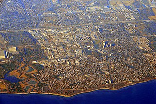
Pickering is a city located in Southern Ontario, Canada, immediately east of Toronto in Durham Region.

<span class="mw-page-title-main">Humber River (Ontario)</span> River in Canada

The Humber River is a river in Southern Ontario, Canada. It is in the Great Lakes Basin, is a tributary of Lake Ontario and is one of two major rivers on either side of the city of Toronto, the other being the Don River to the east. It was designated a Canadian Heritage River on September 24, 1999.

<span class="mw-page-title-main">Rouge River (Ontario)</span> River in Ontario, Canada

The Rouge River is a river in Markham, Pickering, Richmond Hill and Toronto in the Greater Toronto Area of Ontario, Canada. The river flows from the Oak Ridges Moraine to Lake Ontario at the eastern border of Toronto, and is the location of Rouge Park, the only national park in Canada within a municipality. At its southern end, the Rouge River is the boundary between Toronto and southwestern Pickering in the Regional Municipality of Durham.

The Toronto and Region Conservation Authority (TRCA) is a conservation authority in southern Ontario, Canada. It owns about 16,000 hectares of land in the Toronto region, and it employs more than 400 full-time employees and coordinates more than 3,000 volunteers each year. TRCA's area of jurisdiction is watershed-based and includes 3,467 square kilometres (1,339 sq mi) – 2,506 on land and 961 water-based in Lake Ontario. This area comprises nine watersheds from west to east – Etobicoke Creek, Mimico Creek, Humber River, Don River, Highland Creek, Petticoat Creek, Rouge River, Duffins Creek and Carruthers Creek.

<span class="mw-page-title-main">Rouge National Urban Park</span> National urban park in Ontario, Canada

Rouge National Urban Park is a national urban park in Ontario, Canada. The park is centred around the Rouge River and its tributaries in the Greater Toronto Area. The southern portion of the park is situated around the mouth of the river in Toronto, and extends northwards into Markham, Pickering, Uxbridge, and Whitchurch-Stouffville.

<span class="mw-page-title-main">Nescopeck Creek</span> Tributary of the Susquehanna River

Nescopeck Creek is a 37.5-mile-long (60.4 km) tributary of the Susquehanna River in Luzerne County, Pennsylvania. The creek is in the Coal Region of Pennsylvania. The meaning of the creek's name is "deep black waters". The waters of Nescopeck Creek have difficulty ratings between Class I and Class III. However, during parts of the year, Nescopeck Creek is impossible to navigate due to rapids, flooding, and tight bends. Nescopeck Creek is home to a number of species of trout, although the waters are not always optimal for them. Nescopeck Creek's water is acidic, with a pH as low as 3.6 in some studies.

Pickering Village is a former municipality and now a neighbourhood in the town of Ajax, within the Durham Region of Ontario, Canada. The Pickering Village derives its name from the former Pickering Township, which included the present-day town of Ajax and the city of Pickering. A small portion of the original settlement is now part of the Village East neighbourhood in the city of Pickering.

<span class="mw-page-title-main">Ashburn, Ontario</span> Unincorporated community in Ontario, Canada

Ashburn is a hamlet in the town of Whitby, Durham Region, Ontario, Canada, located approximately 15 kilometres north of the town core, and centred on the intersection of Ashburn Road and Myrtle Road. It is a rural settlement area on the Oak Ridges Moraine, situated on the headwaters of the Lynde Creek watershed and part of Ontario's protected Golden Horseshoe Greenbelt.

Greenwood is a small rural hamlet within the city of Pickering in Ontario, Canada.

Brock Road landfills are a series of landfills used by Toronto from 1975 to 1990s. The North and West site are in Pickering, while the South site is in Ajax.

<span class="mw-page-title-main">Petticoat Creek</span> River in Ontario, Canada

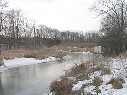
Petticoat Creek is a stream in the cities of Pickering, Toronto and Markham in the Greater Toronto Area of Ontario, Canada. The creek is in the Great Lakes Basin, is a tributary of Lake Ontario, and falls under the auspices of the Toronto and Region Conservation Authority. Its watershed covers 26.77 square kilometres (10.34 sq mi), and the cumulative length of all its branches is 49 kilometres (30 mi). Land use in the watershed consists of 52% agricultural, 27% protected greenspace and 21% urban.

<span class="mw-page-title-main">Duffin Creek Water Pollution Control Plant</span> Water pollution control plant in Pickering, Ontario, Canada

Duffin Creek Water Pollution Control Plant is on the north shore of Lake Ontario in the City of Pickering. It operates as a partnership between The Regional Municipality of York and The Regional Municipality of Durham. The Plant is capable of treating 630 million litres of wastewater each day and serves the communities of York Region, the Town of Ajax and the City of Pickering in Durham Region. Holding ISO 14001 certification, the Plant operates to ensure the environmentally responsible treatment of wastewater.

<span class="mw-page-title-main">Heart Lake Conservation Area</span>

Heart Lake Conservation Area (HLCA) occupies 169 hectares in the Etobicoke Creek watershed, within the City of Brampton, Ontario. It is owned and managed by the Toronto and Region Conservation Authority (TRCA).

Durham Regional Council is the political body for the Regional Municipality of Durham in Ontario, Canada. Created in 1974, it consists of 29 elected representatives, including the Regional Chair. Durham Region is governed by Durham Regional Council, which consists of the mayors of the local municipalities and regional councillors directly elected in each municipality. These members are elected via double direct election. Each municipality elects the following number of regional councillors:

<span class="mw-page-title-main">Lynde Creek</span> River in Ontario, Canada

Lynde Creek is a stream in the municipalities of Whitby and Scugog, Regional Municipality of Durham, in the Greater Toronto Area of Ontario, Canada. It is in the Great Lakes Basin, is a tributary of Lake Ontario, and is under the auspices of the Central Lake Ontario Conservation Authority. The creek begins on the Oak Ridges Moraine in geographic Reach Township in the municipality of Scugog, and flows south to its mouth in the southwest of the town of Whitby. Portions of the 132.19-square-kilometre (51.04 sq mi) watershed also extend into the town of Ajax, the city of Pickering and the municipality of Uxbridge.

<span class="mw-page-title-main">Toronto waterway system</span>

The Toronto waterway system comprises a series of natural and man-made watercourses in the Canadian city of Toronto. The city is dominated by a large river system spanning most of the city including the Don River, Etobicoke Creek, Highland Creek, Humber River, Mimico Creek and Rouge River.

<span class="mw-page-title-main">Duffins Creek</span> River in Ontario, Canada

Duffins Creek is a waterway in the eastern end of the Greater Toronto Area in Ontario, Canada. The watershed of the Duffins Creek is part of the Durham Region and the York Region.

Audley, known as Brown's Corners until 1857, was an unincorporated village in the Pickering Township of Ontario, Canada. In the mid-19th century, it emerged as a stopover for farmers traveling to the Whitby port, and gradually evolved into a village.

The town of Ajax, Ontario in Canada evolved out of the Defence Industries Limited Pickering Works munitions plant built during the World War II, but its history begins much earlier.

References

  1. 1 2 3 4 5 6 TRCA 2002, p. 11.
  2. 1 2 3 4 TRCA 2003, p. 31.
  3. TRCA 2002, p. 2.
  4. TRCA 2002, p. 34.
  5. TRCA 2002, p. 5.
  6. TRCA 2002, p. 8.
  7. TRCA 2002, p. 9.
  8. 1 2 TRCA 2002, p. 13.
  9. TRCA 2002, p. 12.
  10. 1 2 TRCA 2002, p. 15.
  11. 1 2 TRCA 2002, p. 28.
  12. TRCA 2002, pp. 14–16.
  13. TRCA 2002, p. 14.
  14. TRCA 2002, p. 17.
  15. Rob Nisbet 1995, p. 18.
  16. TRCA 2002, pp. 21.
  17. TRCA 2002, pp. 22.
  18. Isaac Callan (2022-04-11). "Almost 1,000 hectares of Toronto and Ajax land granted protected status". Global News.
  19. Keith Gilligan (2020-08-12). "'They understand what flooding means:' Ajax opposed to development in Carruthers Creek headwaters". DurhamRegion.com.
  20. Kristen Calis (2022-03-24). "'This is kind of the heartland of agriculture and nature': Durham Region to consider Greenbelt protection for Pickering's Carruthers Creek headwaters". The Star.
  21. TRCA 2002, p. 19.

Bibliography