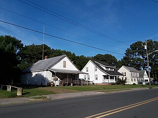
Casa de Piedra (La Paz) | |
|---|---|
Municipality and village | |
| Country | |
| Province | Catamarca Province |
Casa de Piedra (La Paz) is a village and municipality in Catamarca Province in northwestern Argentina. [1]
Casa de Piedra (La Paz) | |
|---|---|
Municipality and village | |
| Country | |
| Province | Catamarca Province |
Casa de Piedra (La Paz) is a village and municipality in Catamarca Province in northwestern Argentina. [1]

The Arctic Archipelago, also known as the Canadian Arctic Archipelago, is an archipelago lying to the north of the Canadian continental mainland, excluding Greenland.

Millville is an unincorporated town and former city in Clayton County, Iowa, United States. The population was 30 at the 2010 census, up from 23 in the 2000 census, before it became unincorporated.

Seward is a borough in Westmoreland County, Pennsylvania, United States. The population was 495 at the 2010 census. It is also one of three communities within the county to utilise the 814 area code, alongside St. Clair and New Florence.
Elmendorf is a city in Bexar County, Texas, United States. It is part of the San Antonio—New Braunfels metropolitan statistical area. Its population was 1,488 at the 2010 census. It was founded in 1885, and named after Henry Elmendorf, a former mayor of San Antonio, and a German-Texan. For a long time, the biggest employer was Star Clay Products.

Melfa is a town in Accomack County on the Eastern Shore of Virginia in the United States. The population was 408 at the 2010 census.
Nett Lake is an unorganized territory in Koochiching County, Minnesota, United States. The population was 56 at the 2000 census.
Bangor is a town in La Crosse County, Wisconsin, United States. It is part of the La Crosse, Wisconsin Metropolitan Statistical Area. The population was 570 at the 2010 census. The Village of Bangor is located partially within the town.

Jason was a Norwegian whaling vessel laid down in 1881 by Rødsverven in Sandefjord, Norway, the same shipyard which later built Ernest Shackleton's ship Endurance. The ship, financed by Christen Christensen, an entrepreneur from Sandefjord, was noted for her participation in an 1892-1893 Antarctic expedition led by Carl Anton Larsen.
Athos Range is the northernmost range in the Prince Charles Mountains of Mac. Robertson Land, Antarctica. The range consists of many individual mountains and nunataks that trend east–west for 40 miles (64 km) along the north side of Scylla Glacier.

Carcedo de Bureba is a municipality located in the province of Burgos, Castile and León, Spain. According to the 2004 census (INE), the municipality had a population of 46 inhabitants.

Villalazán is a municipality located in the province of Zamora, Castile and León, Spain. According to the 2004 census (INE), the municipality has a population of 375 inhabitants.
Mường Lát is a district (huyện) of Thanh Hóa province in the North Central Coast region of Vietnam.
Jutulstraumen Glacier is a large glacier in Queen Maud Land, Antarctica, about 120 nautical miles (220 km) long, draining northward to the Fimbul Ice Shelf between the Kirwan Escarpment, Borg Massif and Ahlmann Ridge on the west and the Sverdrup Mountains on the east. It was mapped by Norwegian cartographers from surveys and air photos by the Norwegian–British–Swedish Antarctic Expedition (1949–52) and air photos by the Norwegian expedition (1958–59) and named Jutulstraumen. More specifically jutulen are troll-like figures from Norwegian folk tales. The ice stream reaches speeds of around 4 metres per day near the coast where it is heavily crevassed.
Ochs Glacier is a glacier flowing to the head of Block Bay between Mount Iphigene and Mount Avers, in the Ford Ranges of Marie Byrd Land.

Demorest Glacier is a glacier on the northeast side of Hemimont Plateau which flows southeast into Whirlwind Inlet between Flint Glacier and Matthes Glacier, on the east coast of Graham Land. It was discovered by Sir Hubert Wilkins on a flight of December 20, 1928, and photographed from the air by the United States Antarctic Service in 1940. It was charted by the Falkland Islands Dependencies Survey in 1947 and named for Max H. Demorest, an American glaciologist.
Tofani Glacier is a glacier flowing northeast into the head of Solberg Inlet, Bowman Coast, to the north of Houser Peak. The feature was photographed from the air by United States Antarctic Service (USAS), 1940, U.S. Navy, 1966, and was surveyed by Falkland Islands Dependencies Survey (FIDS), 1946–48. Named by Advisory Committee on Antarctic Names (US-ACAN) in 1977 after Dr. Walter Tofani, M.D., station physician at Palmer Station, 1975.

Renaud Glacier is a heavily crevassed glacier on the east side of Hemimont Plateau flowing southeast to enter Seligman Inlet between Lewis Glacier and Choyce Point, on the east coast of Graham Land. The glacier was first photographed by the United States Antarctic Service (USAS), 1939–41. Named by United Kingdom Antarctic Place-Names Committee (UK-APC) for Andre Renaud, Swiss glaciologist and chairman of the Swiss Glacier Commission, 1955–74.
Robillard Glacier is a narrow glacier flowing east-northeast and entering the north side of the head of Solberg Inlet, on the east coast of Graham Land. It was discovered by members of East Base of the United States Antarctic Service (USAS), 1939–41, and was photographed from the air in 1947 by the Ronne Antarctic Research Expedition (RARE), under Ronne, and charted in 1948 by the Falkland Islands Dependencies Survey (FIDS). It was named by Ronne for Captain George Robillard, U.S. Navy, of the legal section of the Bureau of Ships, who assisted in gaining Congressional support which resulted in procuring the expedition ship.
Coordinates: 29°35′S65°30′W / 29.583°S 65.500°W