Famatanca | |
|---|---|
Municipality and village | |
| Country | |
| Province | Catamarca Province |
| Time zone | UTC−3 (ART) |
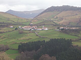
Famatanca is a village and municipality in Catamarca Province in northwestern Argentina. [1]
Famatanca | |
|---|---|
Municipality and village | |
| Country | |
| Province | Catamarca Province |
| Time zone | UTC−3 (ART) |
Famatanca is a village and municipality in Catamarca Province in northwestern Argentina. [1]

The Arctic Archipelago, also known as the Canadian Arctic Archipelago, is an archipelago lying to the north of the Canadian continental mainland, excluding Greenland and Iceland.
Caconda is a town and a municipality in the province of Huíla, Angola. The municipality had a population of 167,820 in 2014.

Borchgrevink Glacier is a large glacier in the Victory Mountains, Victoria Land, draining south between Malta Plateau and Daniell Peninsula, and thence projecting into Glacier Strait, Ross Sea, as a floating glacier tongue, the Borchgrevink Glacier Tongue, just south of Cape Jones. It was named by the New Zealand Geological Survey Antarctic Expedition, 1957–58, for Carsten Borchgrevink, leader of the British Antarctic Expedition, 1898–1900. Borchgrevink visited the area in February 1900 and first observed the seaward portion of the glacier.

The Prince Charles Mountains are a major group of mountains in Mac. Robertson Land in Antarctica, including the Athos Range, the Porthos Range, and the Aramis Range. The highest peak is Mount Menzies, with a height of 3,228 m (10,591 ft). Other prominent peaks are Mount Izabelle and Mount Stinear. These mountains, together with other scattered peaks, form an arc about 420 km (260 mi) long, extending from the vicinity of Mount Starlight in the north to Goodspeed Nunataks in the south.
Saldías is a town and municipality located in the province and autonomous community of Navarre, northern Spain.
Ensay is a currently unpopulated and privately owned island in the Outer Hebrides of Scotland. The island lies in the Sound of Harris between the islands of Harris and Berneray. The name originates from the Old Norse for Ewe Island. It is nothing to do with the Gaelic for Jesus – "Iosa" – as sometimes stated.

Aagaard Glacier, also known as Glaciar Alderete, is an 8-mile (13 km) long Antarctic glacier which lies close to the east of Gould Glacier and flows in a southerly direction into Mill Inlet, on the east coast of Graham Land. It was charted by the Falkland Islands Dependencies Survey (FIDS) and photographed from the air by the Ronne Antarctic Research Expedition during December 1947; it was named by the FIDS for Bjarne Aagaard, a Norwegian authority on Antarctic whaling and exploration.
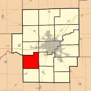
Blue Mound Township is located in Macon County, Illinois. As of the 2010 census, its population was 890 and it contained 387 housing units.

Muros is a municipality in the Spanish province of A Coruña in the autonomous community of Galicia. It is located in the comarca of Muros. It has a population of 10156 and an area of 73 km².
Attlee Glacier is a glacier 8 miles (13 km) long, which flows east-southeast from the plateau escarpment on the east side of Graham Land to the head of Cabinet Inlet to the north of Bevin Glacier.
Džep is a village in Serbia located in the municipality of Vladičin Han, district of Pčinja. In 2002 it had 194 inhabitants.

The Eerste River, located in the Western Cape, South Africa, rises on Dwarsberg 60 km east of Cape Town at the head of Jonkershoek. The Eerste River catchment covers the eastern part of the Cape Flats lying to the west of the Hottentots Holland Mountains and south of the Tygerberg where the Kuils River tributary rises east of Kanonkop. The Eerste River is a short river; its length has been given as 40 km. The major tributary, Kuils River, is approximately 30 km long to its point of confluence with the Eerste River.

Gata de Gorgos is a village in the Marina Alta region of the north Costa Blanca in Spain. It has a population of 5,325 (2005).
San José Banda is a village and municipality in Catamarca Province in northwestern Argentina.
San José is a town and municipality in Catamarca Province in northwestern Argentina.
Grdovići is a village in the municipality of Arilje, Serbia. According to the 2011 census, the village has a population of 519 people.
The White Nunataks are three nunataks standing 3 nautical miles (6 km) north of the northwest tip of Mackin Table in the Patuxent Range of the Pensacola Mountains in Antarctica. They were mapped by the United States Geological Survey (USGS) from surveys and U.S. Navy air photos taken between 1959 and 1966. They were named by the Advisory Committee on Antarctic Names (US-ACAN) for Noah D. White, a radioman at the South Pole Station over the winter of 1967.
Lliboutry Glacier is a glacier flowing southwest from the Boyle Mountains of Antarctica into Bourgeois Fjord, Loubet Coast. It was named by the UK Antarctic Place-Names Committee in 1983 after Louis A.F. Lliboutry, a French physicist and glaciologist who investigated the mechanical deformation of ice and the micro-meteorological properties of ice surfaces, and who also made a general study of glaciers in the Antarctic Peninsula. Lliboutry was Director of the Laboratory of Glaciology, University of Grenoble, 1958–83, and President of the International Commission on Snow and Ice, 1983–87.
26°46′S66°05′W / 26.767°S 66.083°W
| | This article about a place in Catamarca Province, Argentina is a stub. You can help Wikipedia by expanding it. |
