Pampa Blanca | |
|---|---|
Municipality and town | |
| Country | |
| Province | Catamarca Province |
| Time zone | UTC−3 (ART) |
Pampa Blanca is a town and municipality in Catamarca Province in northwestern Argentina. [1]
Pampa Blanca | |
|---|---|
Municipality and town | |
| Country | |
| Province | Catamarca Province |
| Time zone | UTC−3 (ART) |
Pampa Blanca is a town and municipality in Catamarca Province in northwestern Argentina. [1]

Alagoa is a city in the Brazilian state of Minas Gerais. In 2020 its population was estimated to be 2,665.

Loayza or José Ramón Loayza is a province in the La Paz Department, Bolivia. Its seat is Luribay.

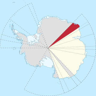
Enderby Land is a projecting landmass of Antarctica. Its shore extends from Shinnan Glacier at about 67°55′S44°38′E to William Scoresby Bay at 67°24′S59°34′E, approximately 1⁄24 of the earth's longitude. It was first documented in western and eastern literature in February 1831 by John Biscoe aboard the whaling brig Tula, and named after the Enderby Brothers of London, the ship's owners who encouraged their captains to combine exploration with sealing.

Shinnan Glacier is a glacier which flows northwest to the coast just east of Shinnan Rocks and marks the division between Queen Maud Land and Enderby Land. Mapped from surveys and air photos by Japanese Antarctic Research Expedition (JARE), 1957–62, and named Shinnan Hyōga.
Maximiliano de Almeida is a municipality in the state of Rio Grande do Sul, Brazil. As of 2020, the estimated population was 4,314.
Sede Nova is a municipality in the state of Rio Grande do Sul, Brazil. As of 2020, the estimated population was 2,891. On July 12 2023 A tornado struck The town with F2 damage.
Laws Glacier is a confluent glacier system which flows into Marshall Bay on the south coast of Coronation Island, in the South Orkney Islands off Antarctica. It was surveyed in 1948–49 by the Falkland Islands Dependencies Survey (FIDS), and was named by the UK Antarctic Place-Names Committee for Richard M. Laws of the FIDS, leader and biologist at Signy Research Station in 1948 and 1949, and at South Georgia in 1951.
Igarapé Riozinho is a river of Acre state in western Brazil.
Ángulos is a municipality and village in La Rioja Province in northwestern Argentina.
El Puesto (Tinogasta) is a village and municipality in Catamarca Province in northwestern Argentina.
La Ramadita is a town and municipality in Catamarca Province in northwestern Argentina.
On the continent of Antarctica, the Aramis Range is the third range south in the Prince Charles Mountains, situated 11 miles southeast of the Porthos Range and extending for about 30 miles in a southwest–northeast direction. It was first visited in January 1957 by Australian National Antarctic Research Expeditions (ANARE) southern party led by W.G. Bewsher, who named it for a character in Alexandre Dumas' novel The Three Musketeers, the most popular book read on the southern journey.
The Boyle Mountains are a wall of mountains standing between the heads of Lallemand Fjord and Bourgeois Fjord, in Graham Land. They were mapped by the Falkland Islands Dependencies Survey from surveys and from air photos, 1946–59, and named by the UK Antarctic Place-Names Committee for Robert Boyle, the English natural philosopher whose book New Experiments and Observations Touching Cold provided the first major scientific and practical approach to a philosophy of cold in all its aspects.
Ward Islands is a group of two small islands and off-lying rocks forming the southern part of the Amiot Islands, off the southwest part of Adelaide Island. Named by the United Kingdom Antarctic Place-Names Committee (UK-APC) for Herbert G.V. Ward, Chief Engineer of RRS John Biscoe, 1948–1962, which ship assisted the Royal Navy Hydrographic Survey Unit which charted this group in 1963.
Moider Glacier is a glacier flowing west into the east side of Dalgliesh Bay, Pourquoi Pas Island, in Marguerite Bay, Antarctica. It was named by the UK Antarctic Place-Names Committee in 1979 in association with nearby Perplex Ridge; the word "moider" can be a synonym for "perplex".
Milestone Bluff is a rock-faced, snow-backed bluff rising to about 830 metres (2,720 ft) just west-southwest of Mount Liotard, in the south part of Adelaide Island, Antarctica. it was so named by the UK Antarctic Place-Names Committee in 1964 because the bluff is an important landmark on the inland route north of Adelaide station.
Steeple Peaks is a line of five distinct peaks, the northeasternmost being Mount Ward, located on the western edge of Palmer Land, south of Conchie Glacier. The area was named by United Kingdom Antarctic Place-Names Committee (UK-APC) because of a number of steeple-like features visible among the peaks.

Starbuck Glacier is a glacier 15 nautical miles (28 km) long, flowing east along the south side of Taridin Ridge and Padesh Ridge, and entering Scar Inlet immediately north of Mount Queequeg, on the east coast of Graham Land. Surveyed and partially photographed by the Falkland Islands Dependencies Survey (FIDS) in 1947. The entire glacier was photographed by the Falkland Islands and Dependencies Aerial Survey Expedition (FIDASE) in 1955–56, and mapped from these photos by the FIDS in 1957. Named by the United Kingdom Antarctic Place-Names Committee (UK-APC) after the first mate on the Pequod in Herman Melville's Moby-Dick.
Regent Reef is an area of submerged and drying rocks forming the northeast limit of the Dion Islands, off the south end of Adelaide Island. Charted by the Royal Navy Hydrographic Survey Unit in 1963. The name given by the United Kingdom Antarctic Place-Names Committee (UK-APC) extends those in the neighboring islands associated with an emperor's court.