
The Arctic Archipelago, also known as the Canadian Arctic Archipelago, is an archipelago lying to the north of the Canadian continental mainland, excluding Greenland and Iceland.
The Wisconsin Range is a major mountain range of the Horlick Mountains in Antarctica, comprising the Wisconsin Plateau and numerous glaciers, ridges and peaks bounded by the Reedy Glacier, Shimizu Ice Stream, Horlick Ice Stream and the interior ice plateau.

The Leverett Glacier is about 50 nautical miles (90 km) long and 3 to 4 nautical miles wide, flowing from the Antarctic Plateau to the south end of the Ross Ice Shelf through the Queen Maud Mountains. It is an important part of the South Pole Traverse from McMurdo Station to the Admundson–Scott South Pole Station, providing a route for tractors to climb from the ice shelf through the Transantarctic Mountains to the polar plateau.
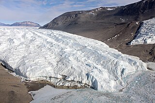
The Taylor Glacier is a glacier in Antarctica about 35 nautical miles long, flowing from the plateau of Victoria Land into the western end of Taylor Valley, north of the Kukri Hills. It flows to the south of the Asgard Range. The middle part of the glacier is bounded on the north by the Inland Forts and on the south by Beacon Valley.
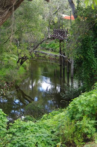
The Harvey River is a river in Western Australia and is the southernmost of the three major waterways which drain into the Peel-Harvey Estuary, with its delta in the southern extreme of the Harvey Estuary. It is about 90 km in length, rising near Mount Keats. Due to flooding of grazing land the river was diverted to discharge directly into the ocean in 1934.
Drygalski Glacier is a broad glacier, 18 nautical miles long which flows southeast from Herbert Plateau through a rectangular re-entrant to a point immediately north of Sentinel Nunatak on the east coast of Graham Land, Antarctica.

The canton of Marle is an administrative division in northern France. At the French canton reorganisation which came into effect in March 2015, the canton was expanded from 23 to 65 communes:
The Kugaryuak River is located in the Canadian Arctic territory of Nunavut in the southwest Kitikmeot Region. It forks into two entities, the Western Kugaryuak and the Eastern Kugaryuak and flows into Coronation Gulf.

Cohuecán (municipality) is a town and municipality in the Mexican state of Puebla in south-eastern Mexico.
Pomancillo Este is a village and municipality in Catamarca Province in northwestern Argentina.
Pomancillo Oeste is a village and municipality in Catamarca Province in northwestern Argentina.
La Carrera (Catamarca) is a municipality in Catamarca Province in northwestern Argentina. It is located within the Greater San Fernando del Valle de Catamarca area.
Santa Rosa (Valle Viejo) is a municipality in Catamarca Province in northwestern Argentina. It is located within the Greater San Fernando del Valle de Catamarca area.
On the continent of Antarctica, the Aramis Range is the third range south in the Prince Charles Mountains, situated 11 miles southeast of the Porthos Range and extending for about 30 miles in a southwest–northeast direction. It was first visited in January 1957 by Australian National Antarctic Research Expeditions (ANARE) southern party led by W.G. Bewsher, who named it for a character in Alexandre Dumas' novel The Three Musketeers, the most popular book read on the southern journey.

Ambergris Glacier is a glacier flowing south-southeast from Mount Sara Teodora between Chintulov Ridge and Valkosel Ridge to join Flask Glacier just west of Fluke Ridge in Aristotle Mountains on the east coast of Graham Land, Antarctica. One of several names in the area that reflect a whaling theme, it was named in 1987 by the United Kingdom Antarctic Place-Names Committee from the substance secreted by the sperm whale and used in perfumery.
Bowman Inlet is an ice-filled inlet between Kay Nunatak and Platt Point on the Hollick-Kenyon Peninsula, on the east coast of the Antarctic Peninsula.

Widdowson Glacier is a glacier situated between Drummond and McCance Glaciers and flowing into Darbel Bay south of Sokol Point, on the west coast of Graham Land.
The Demas Range is a range about 8 nautical miles long that forms the lower east margin of the Berry Glacier in Marie Byrd Land, Antarctica. The range trends north–south culminating in Mount Goorhigian, 1,115 metres (3,658 ft) high.
