Singuil | |
|---|---|
Municipality and village | |
| Country | |
| Province | Catamarca Province |
| Time zone | UTC−3 (ART) |
Singuil is a village and municipality in Catamarca Province in northwestern Argentina. [1]
Singuil | |
|---|---|
Municipality and village | |
| Country | |
| Province | Catamarca Province |
| Time zone | UTC−3 (ART) |
Singuil is a village and municipality in Catamarca Province in northwestern Argentina. [1]

The Arctic Archipelago, also known as the Canadian Arctic Archipelago, is an archipelago lying to the north of the Canadian continental mainland, excluding Greenland and Iceland.

The Flores Sea covers 240,000 square kilometres (93,000 sq mi) of water in Indonesia. The sea is bounded on the north by the island of Celebes and on the south by Sunda Islands of Flores and Sumbawa.
Mankranso is a small town and is the capital of Ahafo Ano South- West, a district in the Ashanti Region of Ghana.
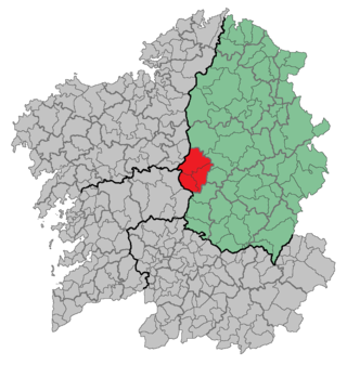
A Ulloa is a comarca in the province of Lugo, Galicia, in northwestern Spain.
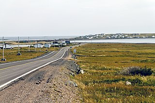
Lamaline is a town in the Canadian province of Newfoundland and Labrador. The town had a population of 480 in 1940, 643 in 1956 and 218 in the Canada 2021 Census. Lamaline was a small place with 10 families in 1864. The Way Office was established in 1863 and the first Waymaster was James Pittman.
El-Sayed Glacier is a glacier about 15 nautical miles long which drains the northeast slopes of Zuncich Hill in Marie Byrd Land. It flows northeast to enter Land Glacier at the south side of Mount Shirley. It was mapped by the United States Geological Survey from surveys and U.S. Navy air photos, 1959–65, and was named by the Advisory Committee on Antarctic Names for Sayed Z. El-Sayed, a United States Antarctic Research Program oceanographer on the International Weddell Sea Oceanographic Expeditions, 1967–68 and 1969–70.

Ahlmann Glacier is the southernmost of two glaciers on the east side of Hemimont Plateau flowing east into Seligman Inlet on Bowman Coast, Graham Land in Antarctica.
Antsotso or Antsoso is a town and commune in Madagascar. It belongs to the district of Betafo, which is a part of Vakinankaratra Region. The population of the commune was estimated to be approximately 15,000 in 2001 commune census.

Codys is a community in Queens County, New Brunswick named after the United Empire Loyalist Cody Family. The 2016 Canadian census found a population of 560.
Iarintsena is a rural municipality in the Central Highlands of Madagascar. It belongs to the district of Ambalavao, which is a part of Haute Matsiatra Region. The population of the commune was estimated to be approximately 22,000 in 2001.
El Bañado (Capayán) is a village and municipality in Catamarca Province in northwestern Argentina.
Los Talas (Catamarca) is a village and municipality in Catamarca Province in northwestern Argentina.
Carbutt Glacier is a glacier entering Goodwin Glacier to the east of Maddox Peak, close east of Flandres Bay on the west coast of Graham Land.
Pollard Glacier is a glacier flowing into the south side of Comrie Glacier to the east of Bradford Glacier, on the west coast of Graham Land. Mapped by the Falkland Islands Dependencies Survey (FIDS) from photos taken by Hunting Aerosurveys Ltd. in 1956–57. Named by the United Kingdom Antarctic Place-Names Committee (UK-APC) for Alan F.C. Pollard (1877–1948), English documentalist, founder and first president of the British Society for International Bibliography, and pioneer in the introduction of the Universal Decimal Classification into British libraries.
Spitz Ridge is a prominent, mainly ice-covered ridge east of Cox Bluff, forming the east end of Toney Mountain, in Marie Byrd Land. Mapped by United States Geological Survey (USGS) from ground surveys and U.S. Navy air photos, 1959–66. Named by Advisory Committee on Antarctic Names (US-ACAN) for A. Lawrence (Larry) Spitz, ionospheric physicist, who wintered at Byrd Station in 1966 and worked additional summer seasons at Byrd and Hallett Station.
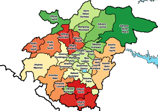
Ahafo Ano South West District is one of the forty-three districts in Ashanti Region, Ghana. Originally it was formerly part of the then-larger Ahafo Ano South District in 1988, which was created from the former Ahafo Ano District Council, until part of the district was split off to create Ahafo Ano South East District on 15 March 2018; thus the remaining part has been renamed as Ahafo Ano South West District. The district assembly is located in the western part of Ashanti Region and has Mankranso as its capital town.
Ahafo Ano South East District is one of the forty-three districts in Ashanti Region, Ghana. Originally it was formerly part of the then-larger Ahafo Ano South District in 1988, which was created from the former Ahafo Ano District Council, until part of the district was split off to create Ahafo Ano South East District on 15 March 2018; thus the remaining part has been renamed as Ahafo Ano South West District. The district assembly is located in the western part of Ashanti Region and has Adugyama as its capital town.
27°49′S65°52′W / 27.817°S 65.867°W
| | This article about a place in Catamarca Province, Argentina is a stub. You can help Wikipedia by expanding it. |
