
Catamarca is a province of Argentina, located in the northwest of the country. The province had a population of 429,556 as per the 2022 census [INDEC], and covers an area of 102,602 km2. Its literacy rate is 95.5%. Neighbouring provinces are : Salta, Tucumán, Santiago del Estero, Córdoba, and La Rioja. To the west it borders the country of Chile.

Rurrenabaque is a small town in the north of Bolivia, on the Beni River. It is the capital of Rurrenabaque Municipality. In recent years, it has become popular with international tourism as it is an easy gateway for visits to Madidi National Park, which is within the Bolivian rainforest. It also provides access to the surrounding pampas. Locals commonly refer to the town by its shortened nickname, "Rurre."

Oruro is a department of Bolivia, with an area of 53,588 km2 (20,690 sq mi). Its capital is the city of Oruro. According to the 2012 census, the Oruro department had a population of 494,178.

Caranavi Province is one of the twenty provinces of the Bolivian La Paz Department and is situated in the department's eastern parts. The province was created by Law 1401 on 16 December 1992 from a portion of what was then Nor Yungas Province. The creation of the province had been a local cause embraced by Ramiro Revuelta, a Deputy in the national legislature who was assassinated on November 28, 1992.

Nor Yungas is a province in the Yungas area of the Bolivian department of La Paz. During the presidency of José Manuel Pando the Yungas Province was divided into two parts, the Nor Yungas and the Sud Yungas Province, by law of January 12, 1899. Its administrative seat is the town of Coroico.

Enrique Baldivieso is a province in the Bolivian department of Potosí. It is named after the former vice president Enrique Baldivieso. Its seat is San Agustín with a population of 533 during the census of 2001 situated on the bank of the Turuncha River in San Agustín Canton.
Tinogasta is a city in the west of the province of Catamarca, Argentina, on the right-hand shore of the Abaucán River, about 280 km from the provincial capital San Fernando del Valle de Catamarca. It had about 11,500 inhabitants at the 2010 census [INDEC]. It is the head town of the department of the same name. The name of the city comes from the Kakana words tino ("meeting") and gasta ("town").
Sajonia is a barrio (neighbourhood) of Asunción, the capital of Paraguay. It is located next to the Paraguay River and has a population of 14,873 people. This barrio is home to different social classes, but most predominantly middle- to upper-class families. The Carlos Antonio López Avenue runs through Sajonia.
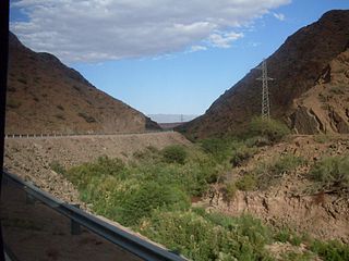
The Abaucán is a river in Argentina which flows through the provinces of Catamarca and La Rioja, areas with very low precipitation. The river water is provided by the ingress of two larger rivers, the Fiambalá and the Chaschuil.

Cardeñadijo is a municipality located in the province of Burgos, Castile and León, Spain. According to the 2004 census (INE), the municipality has a population of 668 inhabitants.
Coripata is a town in the La Paz Department, Bolivia.
Banda de Lucero is a village and municipality in Catamarca Province in northwestern Argentina, and is located in the Tinogasta Department.
Cordobita is a village and municipality within the Tinogasta Department of Catamarca Province in northwestern Argentina.
El Puesto (Tinogasta) is a village and municipality in Catamarca Province in northwestern Argentina.
La Puntilla (Tinogasta) is a village and municipality in Catamarca Province in northwestern Argentina.
Medanitos (Tinogasta) is a village and municipality in Catamarca Province in northwestern Argentina.

Saujil (Tinogasta) is a village and municipality in Catamarca Province, in northwestern Argentina. Saujil translates as "illuminated place" in the indigenous Cacán language.
Santa Rosa (Tinogasta) is a town and municipality in Catamarca Province in northwestern Argentina.
Vicente Phillip Reyes Núñez is a professional footballer who plays as a goalkeeper for EFL League One club Cambridge United on loan from EFL Championship side Norwich City. Born in the United States, he represents Chile at youth level.

